Monday, Aug 28th, 2023, 0930-1920
Hwy 36 to Cold Spring
26 miles, Gain 5085′, Loss 3645′, elevation 6500′
Once I left town, it was a pretty uneventful day. I was slow in packing and eating some leftover Velveeta shells and cheese for breakfast. I said goodbye to Annika and Michael, then hit the grocery store for a few more items. I was very impressed by the selection and size of the store. I wish I had gone there first before the Dollar General. As I was leaving, a man asked if I needed a ride to the trailhead. Wow, that was easy! Perhaps he had come up with the best tactic for getting women into his car: live in a trail town and offer hikers rides. Since I hadn’t heard of dozens of hikers going missing in Chester, I figured he was sincere. He also mentioned offering a ride to another hiker who was at the PO, switching out his backpack. I knew that was Keys, so his story checked out.
We drove over to look for Keys but couldn’t find him outside. We assumed he’d already gotten a ride but I should have gone inside the PO to look for him, because apparently he was still in there (pieced together after talking to him later). Poor Keys, I poached his ride. Terry, the driver, was the sweetest man, but we couldn’t help but get into the politics surrounding the fire…namely to bemoan the dreadful power company. Terry had almost lost his home and now the town was suffering from the decreased tourism to the area. Had anybody even been compensated for their losses, I wondered? How do you put a price tag on lost business because no one wants to come to your resort town anymore because it looks like a wasteland?
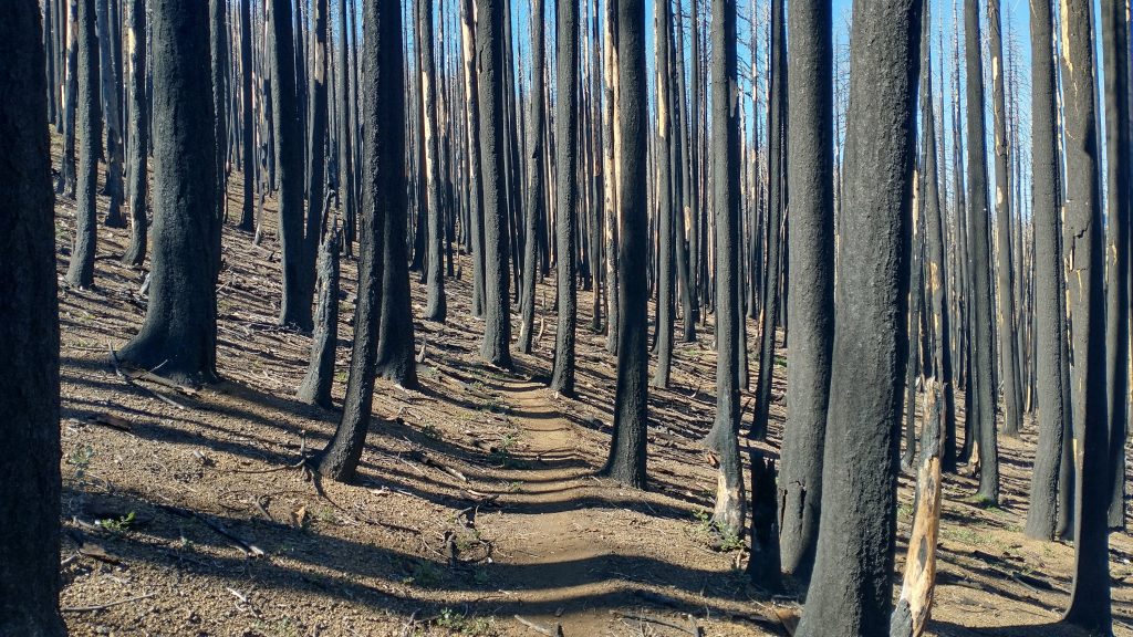
I pondered the loss and devastation as I walked through more burn, across the valley and all the way up Butt mountain. This is where the PCT halfway marker stood, but it didn’t feel like a celebratory occasion or location this time around. I remembered being so happy and even emotional last time. I didn’t even know where my halfway marker was on this thru hike…I hadn’t been certain enough of my route and side trips to calculate it beforehand (I went back through my blogs later to find that I hiked about 915 miles up to this point, including side-trips, so it was close to a halfway point for the Triple Crown Trails). Now I was surrounded by dead trees and it didn’t feel noteworthy. I knew the burn areas extended nearly all the way to Sierra City, so I wasn’t looking forward to the next 4 or 5 days.
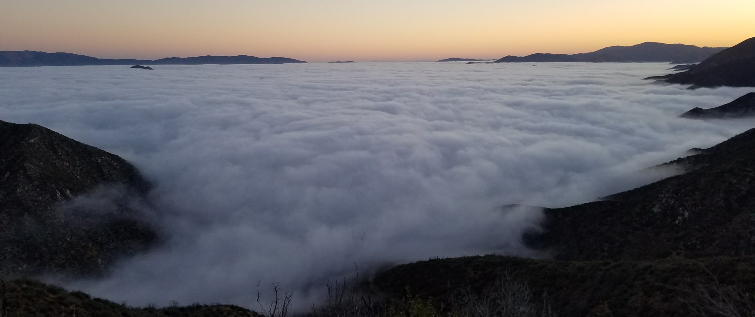
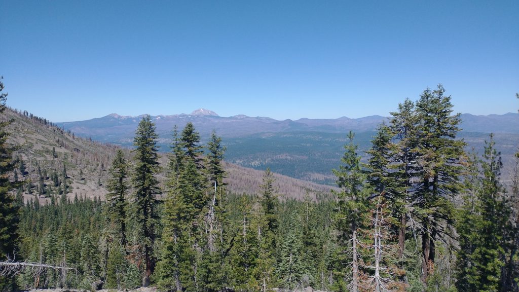
I continued along the ridges, enjoying good views and parts that I recalled that still looked the same. I had great sightings of Lassen and down into the valleys. I even spied the shark-fin profile of Sierra Buttes to the south, marking the location of Sierra City, where I’d be in a few days. Incredibly, I could also make out the profile of mountains across the central valley. My Peakfinder app told me they were the Yolla Bollys and Trinity Alps. What also gave them away were the plumes of smoke rising from them and filling the central valley to the north. The plume from the Stuart Fork “Deep fire” was especially prominent…a large mushroom cloud. Looking at the burned trees all around me and thinking back on that beautiful valley, my heart ached.
I stopped to collect water from a spring that was a little ways down a drainage, as they all tended to be in this area. Hikers hate having to go off trail to get water but I dropped my pack at the top and the trip took only about 15 minutes. I had lunch, noting how quiet the trail had been. From the halfway register, I knew Slingshot was just in front of me. She was in town the day before and had lunch with Keys and me. I gathered that he was behind me, since I didn’t see his name. We seemed to be in a bit of a hiker void, created by the rain event the week before. I must have walked ahead of the bubble that left from Mt. Shasta\Dunsmuir after the rain and was a day or 2 behind the next bubble. Chester had been a popular point to flip-flop to when so many NOBOs skipped the Sierra. They had gone north from Chester to the Canadian border, and now many were coming back to go south from there. It was often very confusing to ask a hiker what their path had been. As for me, I could see eyes glaze over when I tried to describe my route, so it was easiest not to say anything at all. I simply said I was southbound.
I finally passed a few hikers in the last hours of the day. Two were day hikers and 3 NOBOs that had gone continuously through the Sierra and were just about to get to the halfway point this day or the next…at the end of August. I climbed a fair bit and ended at a spring, where I recalled having lunch the time before. I was still in a burn scar but I needed to call it a day. Slingshot was at the spring too, so I pitched nearby. A few cars came by on the dirt road, which always made me nervous, but it was a good night anyway.