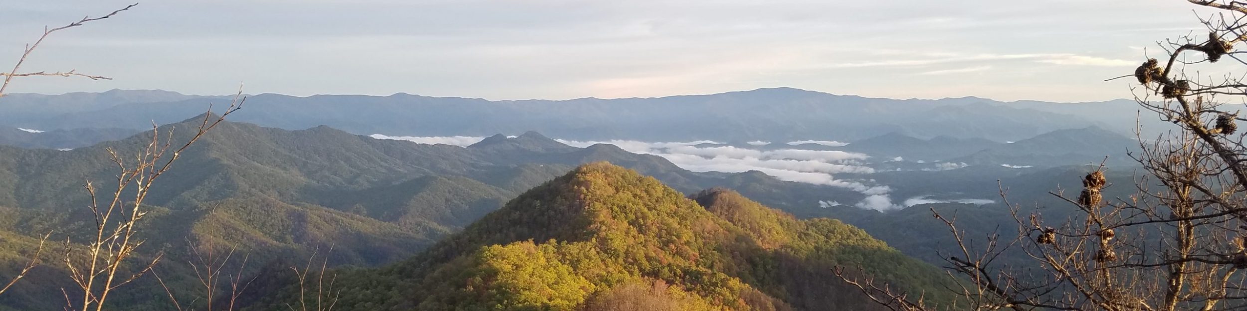
My intention for this post is to help future PNT hikers in answering the age-old question: Which way should I go? I’m not saying that anyone has to follow my advice, just explaining why I chose certain options and what I thought of them at the time. Though, there are a few routes that I STRONGLY encourage, either for the wow-factor or to hopefully save a hiker some misery. The PNT is full of ‘alternates,’ so it’s very much a choose-your-own-adventure type trail, similar to the CDT. Recalling that the official trail is depicted as a red line on the Far Out app, alternate routes are usually drawn as a blue line, but sometimes other colors such as purple or pink. The PNT occasionally throws a curve ball when the alternate route IS the red line…a route that’s so infrequently used / maintained that the notes actually state that it’s not recommended! This has to do with the PNT being officially recognized as a National Scenic Trail by congress many years ago. As new/better routes and trails were developed and became the preferred way, they still have yet to be re-designated as the official trail. Bureaucracy moves at a slow pace…and so will you, if you always stick to the red line.
Also take note that due to my flip flop on the PNT, a lot of the following information is rather specific to my EABO then WEBO experience. Direction DOES MATTER a lot when it comes to deciding which route to take on the PNT! The best example of this is probably the the Lions Head section in the Selkirk mountain range, west of Bonners Ferry. For this reason, I’m going to start by discussing the options for this, the most notorious of the PNT bushwhacks. Following this first example, I’ll address the rest of my route choices in order of the day I came to them.
Lions Head bushwhack routes, Selkirk mountain range:
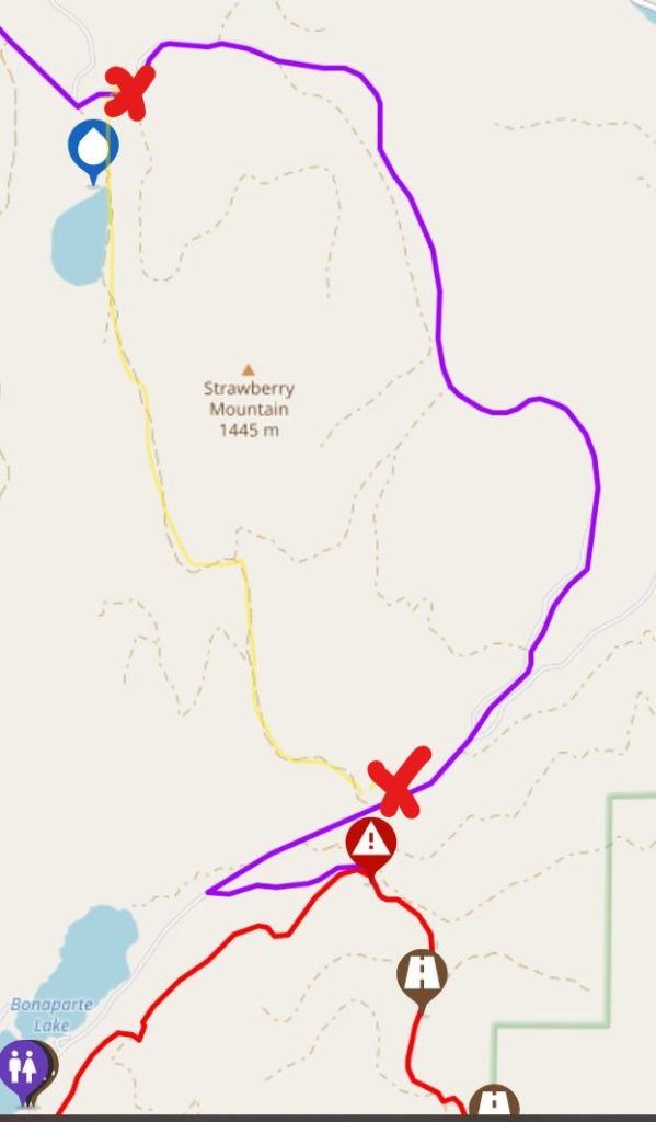
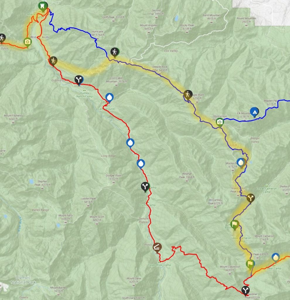
It’s important to first point out that the FarOut app uses a thicker line to denote a bushwhack section (no built trail), almost appearing as if the route were ‘highlighted’ rather than drawn in with the normal thin solid line (see below). This is a common feature of the PNT guide, since there are quite a few bushwhack sections. I quickly learned that not all bushwhacks are created equal…one should get a sense for this after reading this post. I’ve also captured screenshots using the ‘plan a route’ tool, which highlights a trail segment in yellow from user-selected green-start and red-end points. I’d suggest getting really comfortable using this tool, since it’s the only way to see the elevation profile of an alternate route. FarOut also calculates the distance and elevation gain/loss for the selected segment, so it’s a very practical and helpful feature!
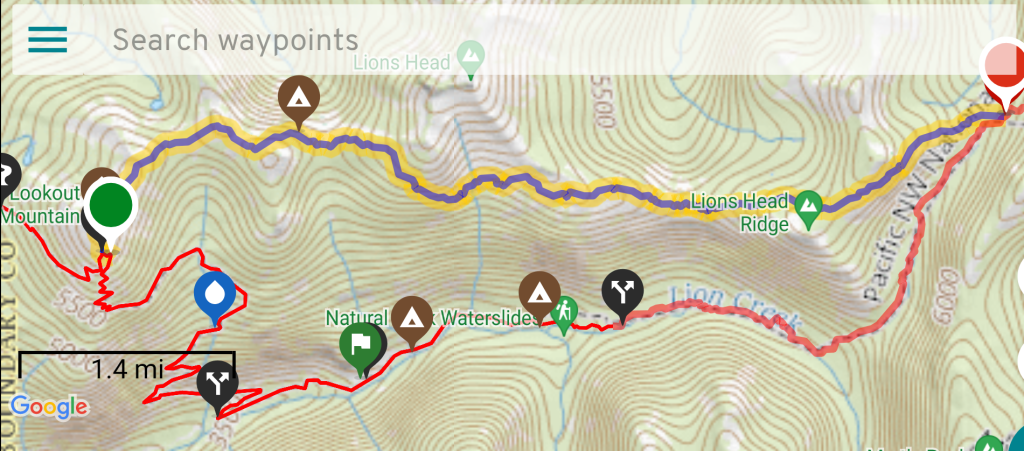
I tackled the Lions Head Ridge route, blue line (highlighted above), on Day 15 of my EABO flip. It’s approximately 8.6 miles from where it departs and then meets back with the red line (green to red markers). The ridge route requires good navigation, a little bit of class 3 scrambling and some exposure. Because it follows a rugged ridgeline, it also goes up and down a fair bit, so overall there’s more elevation gained and lost. By the numbers, the red line seems like a much better option, especially going WEBO. From the saddle on the eastern side (red point), the bushwhack is much shorter (4 miles) and is all downhill. Built trail resumes about halfway along the red line, near where the 2 campsites and waterslides are indicated on the map. Navigation is rather straightforward in following the red line down the valley to Lion creek, which also serves as a reliable water source the rest of the way.
At the west end junction marker, hikers also have the option of staying on the road that goes straight to the Priest Lake Campground, avoiding a steep and massive 3k’ climb to Lookout Mountain. This is a very tempting option for WEBO’s that have already persevered through several difficult days in the Selkirks…but still, I’d have hated to miss out on Lookout Mountain. The biggest downside of the red route is that all 4 miles of the bushwhack involve navigating a willow and log-choked creekbed with no views. Such conditions suck no matter what, but are especially bad heading uphill since willows and blowdowns predominately point downhill (going against the grain)…plus there’s good old gravity at play, too! This is a big factor for EABO hikers considering which route to take.
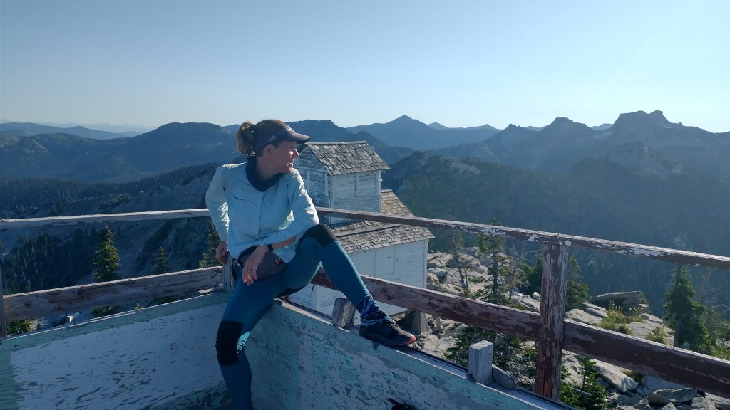
For many reasons I’ve already eluded to, the blue ridgeline route is probably much better/easier going EABO than WEBO. Starting from Priest Lake, an EABO hiker needs to gain 4250′ in elevation to get to the main north-south ridge on the eastern side of the Selkirks, regardless of which bushwhack route they take. I figured it was better to gain the majority of this elevation on the trail to Lookout Mountain (part of the official red line, not shown on map above), rather than along the creek bushwhack. Departing Priest Lake, an EABO hiker will presumably have pretty fresh legs heading to the top of Lookout Mountain, plus there’s often access to a snow-fed pond to pick-up some water just before the start of the blue route. From the platform on Lookout Mountain, nearly all of the route can be scouted and studied. If the ridge looks too hairy from here, it’s still an option to follow the red line, descending back to the valley.
The first 6 miles of the ridgeline route were a real joy, with fairly easy travel along rock slab and sparsely vegetated ridgelines. Coming to the saddle at the eastern end of the route was where the bushwhacking was the most dense and time-consuming. At least I was nearly done by that point and mostly going downhill towards the saddle. Bashing through the saddle and up towards the main ridge sucked the most but I would have needed to do this anyway along the red route. Two more miles of route finding to Upper Ball Lakes followed, but it was mostly just sparse ridge hiking once again. Aside from the very end, I absolutely loved Lookout Mountain and the Lions Head ridge. The views were spectacular, making it one of my best days on trail. Other hikers have described the Lions Head bushwhack as their worst experience. Perhaps when faced with a wall of dense bush and limited views of the ridge route, WEBO’s invariably take the standard route down the creek, missing out on all the fun of Lions Head ridge. Or maybe the ridge proves to be way too tedious for some. Which will it be for you? Hopefully after reading all this, you’ll have an inkling that it probably depends on your direction.
Here are the rest of my route choices: EABO Days 1-33 (except WEBO Days 5-6), Oroville to East Glacier
Day 2, Section 5: I took the purple line to bypass Bonaparte Mountain, which was still closed due to a 2021 fire. Havillah to Bonaparte lake : about 16 miles. The purple alt was (mostly) dirt road walking, with hardly any traffic (even on the 4th of July weekend), taking me to Lost Lake. From there, I followed quiet FR 050 (not marked as an alt but shown on the map) south almost directly to Bonaparte lake, rejoining the red line after visiting Bonaparte campground and restaurant. The FR 050 probably saved a few miles and avoided paved road. Hopefully the trail over Bonaparte mountain re-opens soon but even when it does, this is a nice road walk to avoid possible snow or to take advantage of nice campgrounds around the lakes.
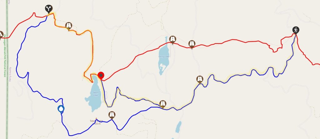
Day 4, Section 4: South of Republic and to the west of HWY 21, I took the shorter (2.3 miles) red “bushwhack” that goes NW of Swan Lake. Much of it’s on an old road bed and had seen recent maintenance. It was a little confusing and overgrown coming down the hill in the close vicinity of Swan Lake. East of Swan Lake, I stuck to the blue alts that follow paved and dirt roads…easy and little traffic, 5.4 miles. The red line had almost no comments about it, so not sure anyone’s braved it in a very long time==best to avoid.
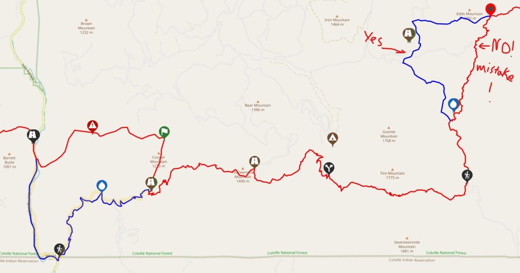
Days 5 & 6, Section 4 (heading WEBO to take advantage of the network of highways/trailheads surrounding Republic, resulting in a net elevation loss for this section): South of Republic and east of HWY 21, there are 2 blue alts…DEFINITELY take both of them! I unfortunately took the eastern 3.5 mile red bushwhack near Edds Mountain, which was perhaps my biggest mistake the whole trail. It did not save any time over the 5.1 mile blue alt, as it was very steep and dense bushwhacking at 1mph or less pace. Just NO! I didn’t even consider the second red bushwhack section that takes a more northerly approach towards HWY 21 (eliminating a 3 mile road walk on the highway), as a local trail angel told me that she’d hiked parts of it years ago and it was in terrible shape with cliffs and washouts. Plus, it would require crossing the Sanpoil river, which was running very high and swift when I went past. Facing such a dangerous river crossing at the very end of the red alternate would have been devastating, I think. This river crossing is not made very clear in the notes but is a very crucial consideration. The blue alt is mostly on nice trail and the 3 mile road walk on HWY 21 was easy, with hardly any traffic and no need to ford the river as there’s a bridge across it.
Day 7, Section 4: Northeast of Republic/East of Curlew, I took a short detour onto Upper Butte Creek Rd, which paralleled the Kettle Crest Trail from Boulder Creek Rd/Deer Creek Summit Campground to the marked junction waypoint, 3.5 miles south. The road lies west of the trail, is closed to vehicles for more than half the way…saw none anyway, is about the same distance as the trail, and (for me, early in the season) alleviated a couple miles of crawling over blowdowns. It’s not marked as an alt but the road appears on the map and there are comments about it in FarOut.
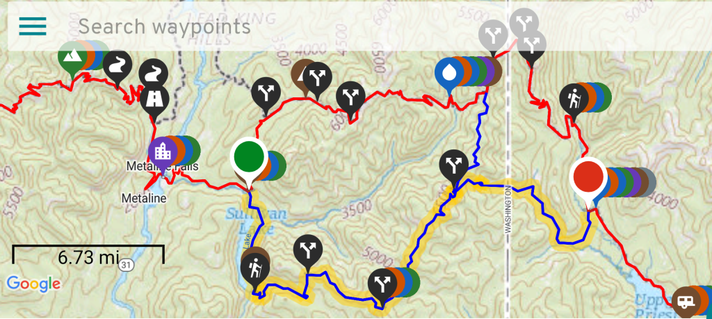
Days 13-14, Section 3: East of Metaline Falls, I took the Blue southern route along Sullivan lake, up Noisy creek, along Grassy Top and other ridges of the Shedroofs, then down Jackson creek, reconnecting to the red line after about 36 miles, near Upper Priest Lake. This route was nice, with pretty well-maintained trails the whole way. Notes warned against taking the red line and were pretty dated. I think fires have decimated the area and the red trails have been all but abandoned. It’s one of those where even the PNTA recommends the blue alt.
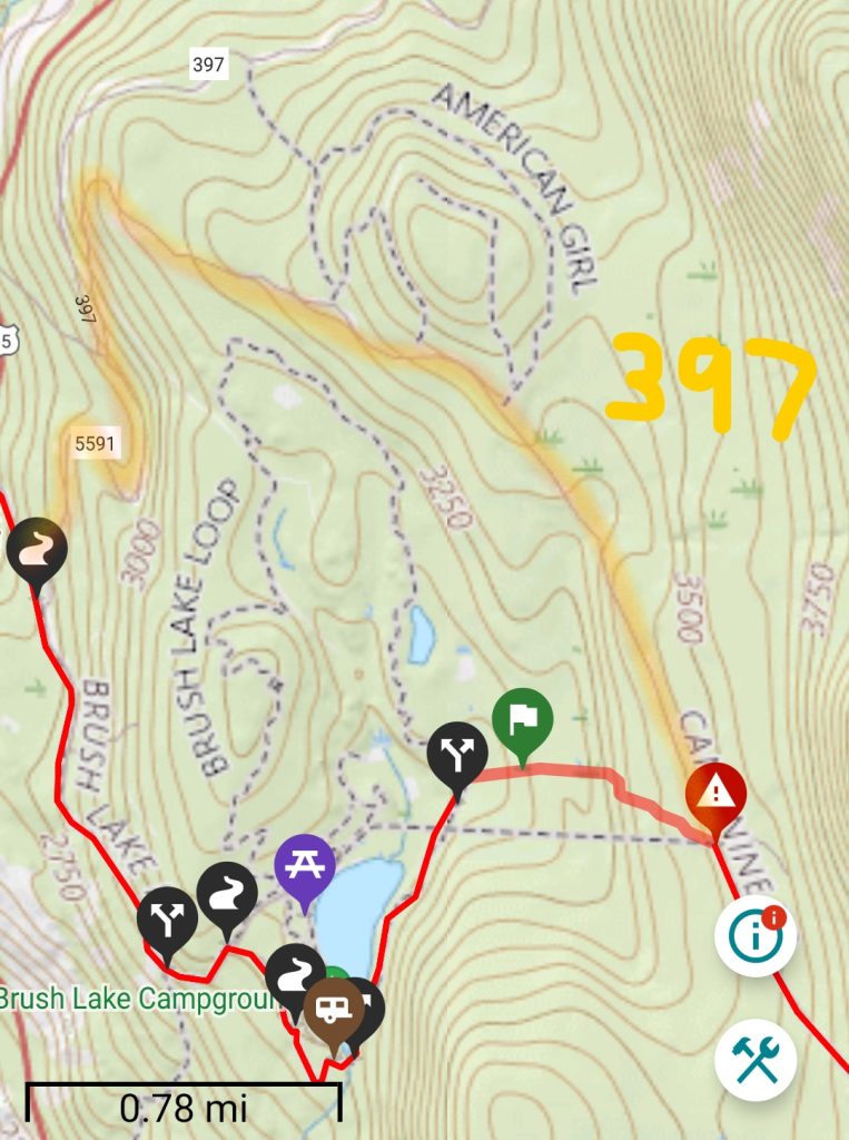
Day 18, Section 2 Brush Lake bypass (just east of Bonners Ferry): This is a roughly 4 mile road walk on FR 397 to avoid a 0.7 mile bushwhack to/from Brush Lake, not marked as an alt on FarOut but there are comments at the junctions. It’s probably only half a mile longer than following the red line and is easy. Having just left Bonners Ferry, I had no reason to visit the lake and didn’t want to struggle uphill against the willows. Smart choice!
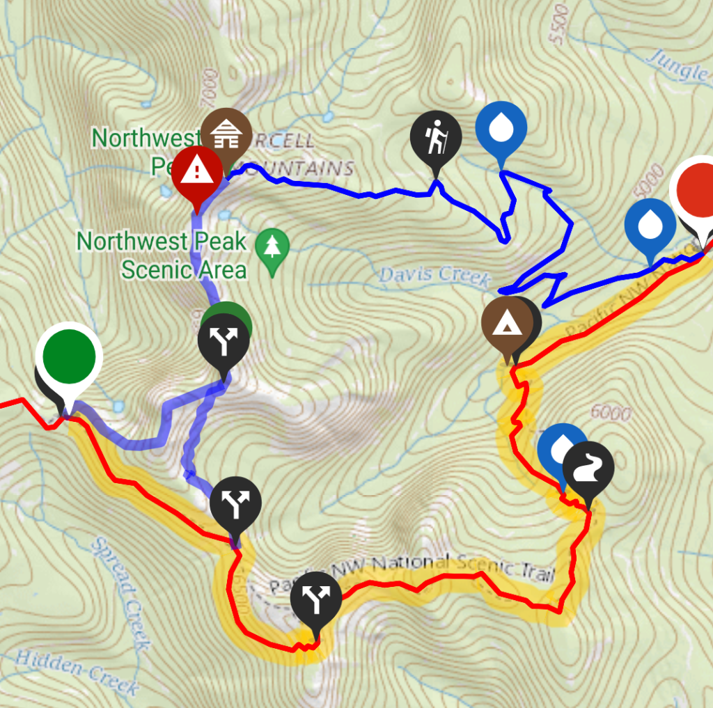
Day 19, Section 2 Northwest Peak series of alternates: Here I stuck with the red line because 1. I got to the alternate junction late in the day and the blue line would have involved going uphill even more with no apparent places to camp. 2. The blue line involved scrambling and route finding, all of which I’d already gotten plenty of from the Lions Head ridge route. The red line was good, straightforward trail with great alpine views along Rock Candy Mountain…so you can’t really go wrong taking either! The blue alt is about 1 mile longer (11.5 vs 12.5 miles) and the lack of defined trail in places will definitely make it take longer. But there are supposed to be some epic views and a cool cabin/lookout, which are nice trade-offs. It’s probably good training for doing the Lions Head ridge route, as well. If you have time and the snow/weather isn’t a factor, I say go for the adventure of the blue alt.
Day 21, Section 2 road walk & Vinal Creek trail to Turner Falls (east of Yaak): This is an unofficial alternate that avoids some PUD’s and is probably faster. The road walk on FR 746 was easy, as was finding the trailhead along Vinal Creek. The hike up the creek was nice, with bridges, recent maintenance, and hardly any blowdowns all the way to Turner Falls. The creek can get overgrown in places… just like the rest of the PNT. At the trailhead, WEBO’s can take a more direct series of logging roads to head straight towards Yaak, if desired. See comments in FarOut.
Days 24-25, Section 1 Whitefish mountains: There are several blue alts through the 10 Lakes Scenic Area, but I stuck to the red line and was happy. There are also many other trails and roads throughout this region, offering options in case hikers need to bail from a ridgeline. I didn’t feel the need to research the alts, given the nice weather, lack of fires and snow when I passed through. The red line trail was in good shape. Fires and snow can frequently impact this area, so it will just depend on current conditions.
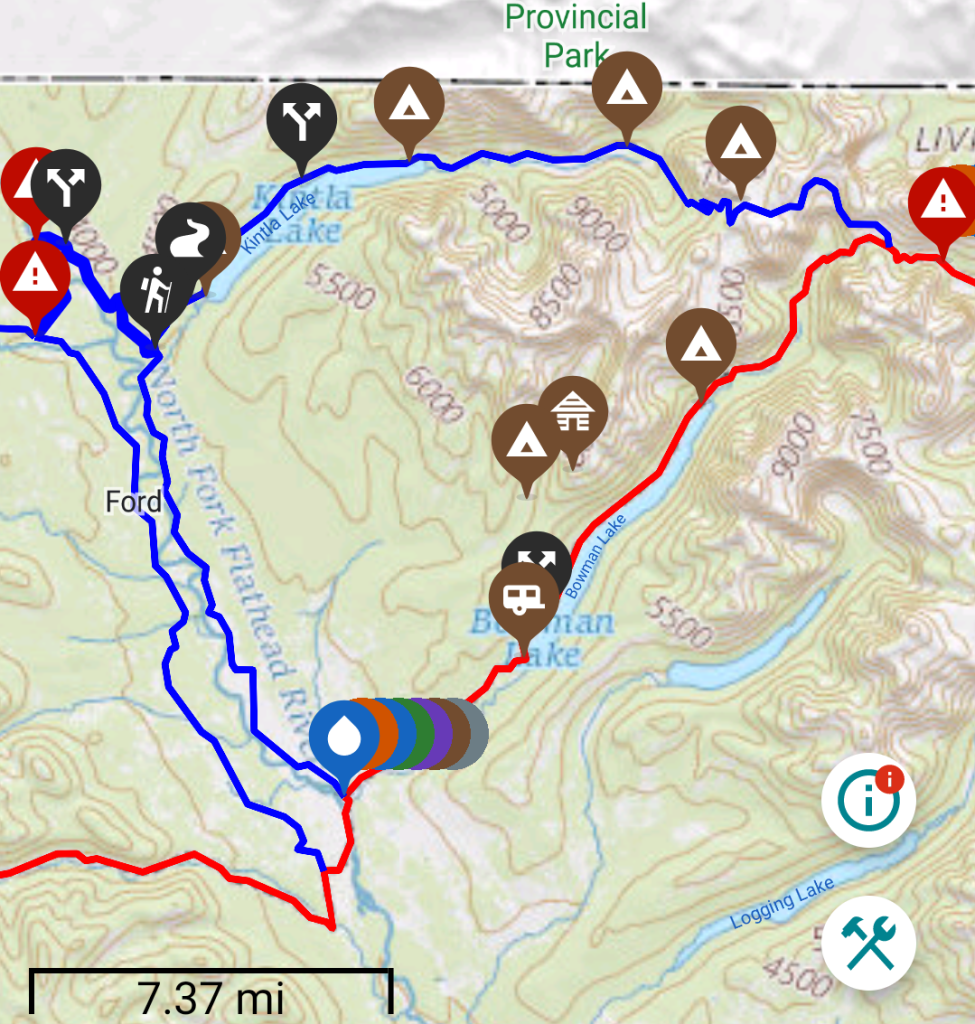
Days 27-28, Section 1 Kintla Lakes and Boulder Pass Blue Alt (Polebridge to Brown Pass): I can’t stress enough how much I loved this route! It’s easily my favorite part of Glacier National Park, so far. That’s saying a lot since I’ve now hiked the eastern north-south corridor of the park, from Chief Mountain to East Glacier as part of the CDT, as well as west to east in the northern reaches of the park, as part of the PNT. ALL of GNP is amazing, so it doesn’t really matter what route someone takes to have a fantastic time. But if I had to rate the top 5 passes I’ve hiked in GNP, they would be 1. Boulder Pass, 2. Standing Indian Pass, 3. Piegan Pass, 4. Triple Divide Pass, 5. Ptarmigan pass and tunnel.
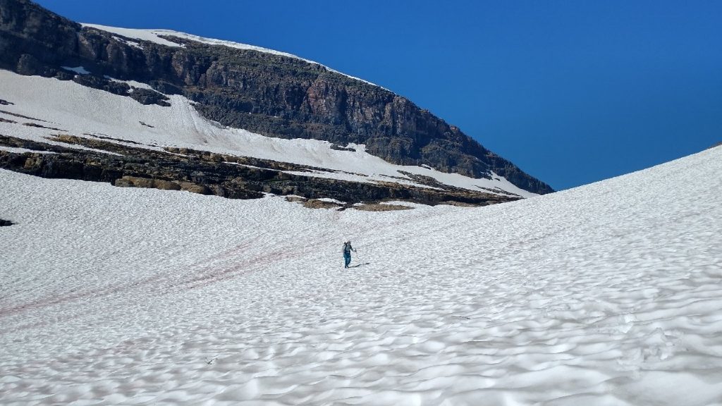
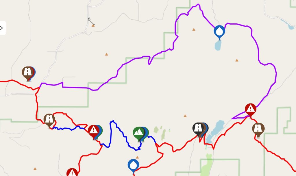
This blue route is 15 miles longer than the red line…but don’t let this be the only excuse to not do this route! One could easily hitch the road from lower Kintla Lake to Polebridge, negating the extra distance and a crummy road walk, to boot. There’s quite a bit of traffic going to the lake, so a little yellow-blazing is definitely worth it for this fantastic experience. The most decisive factor will be snow. Even at the end of July, park rangers were trying to dissuade us from hiking this route. Boulder Pass is 1,200 feet higher from where the route departs the red line at Brown Pass, thus it holds snow well after all the others. The pass tops out at around 7500′ in elevation, which makes it a contender for the highpoint of the entire PNT…the only pass slightly higher is Cathedral Pass in the Pasayten Wilderness. On the eastern side of the pass, there are high exposure switchbacks leading up a series of terraces that would probably be pretty treacherous when covered by snow. We were still crossing large snow fields at the saddle and small patches along the switchbacks, when Stoney Indian Pass was already completely devoid of snow. So if a hiker finds Stoney to be a problem, then Boulder will most likely be a no-go. As such, this alt isn’t usually an option for WEBO PNT hikers starting in late June or early July. It’s worth considering a flip-flop on the PNT, just to be able to take this alternate! See my PNT Flip-Flopper’s Guide.
Day 28, Day 29 & Day 30, Section 1 GNP, Waterton Monument Bonus, Ptarmigan Tunnel and exit to Many Glacier, in lieu of finishing at the official Chief Mountain PNT Eastern Terminus: In short, this was an opportunity for me to hike new parts of Glacier National Park and finish in a touristy spot, where it was easy to hitch to East Glacier (to catch the train). You can read all the specific details in my daily posts. Chief Mountain trailhead is nothing special, especially if you’ve already been there before. There are any number of places to begin/finish the PNT throughout the park, so do some research to make up your own route to enjoy and also maybe save some money in shuttle costs! This of course depends a lot on the time of year and availability of permits.
Now WEBO: Days 34-60, Oroville to Cape Alava:
A note about the blue ‘shortcut’ alternate just north of Palmer Lake and Loomis, west of Oroville. It’s tempting to follow this ‘route’ because it cuts off quite a bit of road walking. I didn’t take it because it looked super sketchy and steep. After talking first-hand with the German couple that did take it, they warned that it was one of the most dangerous things they’ve ever done. It also took them much longer than if they’d just walked the road. These were some hard-core hikers that also did the Lions Head ridge route (same day as me) and Boulder Pass in GNP weeks before me, when there was way more snow. So I trusted that they weren’t over-exaggerating. They strongly felt that the blue line should be removed from FarOut altogether, before someone dies. Pretty compelling advice plus the one and only advantage (less road walking) make it just not worth the risk.
Day 38, Section 6, Jackita Ridge unofficial alt: Just east of Ross Lake is a trail that goes from from Devils Pass to the highway, shaving about 5 miles over the red line. The trail can be viewed on the Hiking Project app. I wouldn’t recommend it if Canyon Creek, flowing along the highway, is running high. The bridge was out and so we had to ford it…fairly easy at the time but it’s a pretty sizable and fast-flowing waterway. The trail was in decent shape but there are some steep ups and downs. We walked the highway for about 3 miles to connect to the red line at the SE tip of Ross Lake. There was a good shoulder and not too much traffic. I enjoyed this shorter route but I’m sure the red line is fine too.
Day 45, Section 7, Mt Josephine: I took the purple alt, as was prescribed at the time, to avoid logging activities near the summit of Mt Josephine. Do whatever the comments suggest. This area is all logging roads and clear-cuts, so you’ll probably want to do whatever gets you out of the area as quick and easy as possible. Also, I elected to continue on the red line along the logging hills, rather than taking the popular blue alt rail-trail from Lyman to Sedro-Woolley. It just seemed the least complicated option at the time, plus I’d already visited town and didn’t need to again. I actually enjoyed the views from Lyman Hill and all the logging roads were dead quiet on a Sunday.
Day 46, Section 8, Anderson Mountain cut-off Blue alt: Just east of I-5 is a big climb up a sizable logged hill. Near the top is an option to stay on the road (blue, 0.6 miles) or dive off into the bush following the 3 mile red line, and from the sounds of it, battling to find any semblance of trail. This was no-brainer for me. There were good views of Rainier, Baker, the sound, and Olympics at the top, so definitely worth the climb overall, but why waste time bushwhacking around here? The Olympics await!
Day 48, Section 9, Oyster Dome, between Lake Samish and Samish Bay: I stuck to the red line through here, though I did take the short side-trip to Oyster Dome…worth it for great views of the San Juan Islands!
Day 49, Section 9, March Point Peninsula short-cut: Just east of Anacortes, the red line follows a road around March Point, while an unofficial cut-off, North Texas road, goes across the center of the peninsula. I didn’t see any problem with trading a road walk for a shorter one, as long as I accounted for the difference in my daily miles. It saves about 3 miles. I also recommend sticking to the red line in following the maze of trails west of Anacortes, all the way to Deception Pass. I had to check my maps/GPS a lot but enjoyed being in the woods on a trail and not on a road.
Days 49-50, Section 9, Whidbey Island: Here, there are many options to walk the beaches during low tide or to take road alternates when the tides are not favorable. You can also cut off lots of extra miles by sticking to more direct routes…take a look at a map and tide chart to decide what works, given the circumstances. For the first day, I stayed on the beach all the way around Hoypus Point in the north part of the island. The next day, I cut off some of the road walk by taking a right on E Frostad rd (supposed to go left) and connecting to HWY 20 to Ault Field rd. I also walked West Beach Rd all the way to Libbey Rd, then a series of mountain bike trails in Kettles Park that took me down into Ebey State park and Ebey’s landing. For these trails, I consulted my Hiking Project app and a local bike trails map, provided by the Happy House. I wish I could be more specific about all the trails I followed but I wasn’t paying very close attention and was wondering around in a maze of trails for a bit…probably no one would want to repeat my path. This whole day was spent seeking alternates to avoid the 13 miles of beach walking on the west side of the island, since the high tide was around 1 pm, eating up most of the day. No huge loss if you can’t walk these beaches…you’ll get plenty more on the Olympic coast.
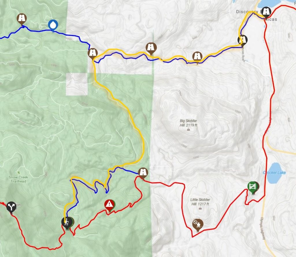
Days 51, Section 9, departing Port Townsend for the Olympics: The Olympics present a very confusing network of alternates. Broken down into sections, it’s not as bad as it looks. I went with the most popular combination of blue alts and was not disappointed. For starters, I elected to get a ride for 6 miles along HWY 20, from Four Corners crossing to Discovery Bay. This was the only road segment of the PNT that I intentionally skipped. It just didn’t sound very safe and I was not in the mood after some close calls with traffic on similar HWY 9, north of Sedro-Woolley. I didn’t regret not connecting my footsteps here.
From Discovery Bay, I wanted to avoid the busy road walk on HWY 101, so I took the blue alt to Snow Creek Road, an unofficial forest service dirt road that cuts across to the southern blue alt (see map below). There are good notes about this route in the FarOut comments. The beginning of the blue line leads past a trail angel cabin (Salmon Creek Road), which provides a nice alternative to staying in expensive Port Townsend (I didn’t stay here but did check out the cabin on my way past…it was cute!). From the cabin, it’s some light bushwhacking through nettles and onto a mixture of old logging roads. Snow Creek rd was a significant and obvious road, easy to follow. I saw 3 vehicles and a motorcycle on a Saturday, so don’t expect much traffic. I calculated that it was about 3 to 3.5 miles from the northern blue alt to the southern one. I took the southern blue alt since it was a simple dirt road walk, versus an unknown bushwhack along the red line…having made it this far on the PNT, I just knew better! It was also late in the day and I needed to find a campsite along the road.
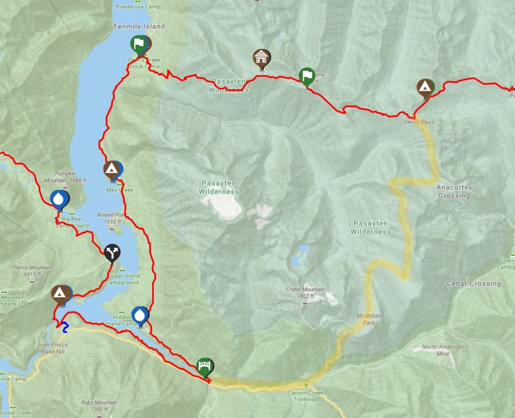
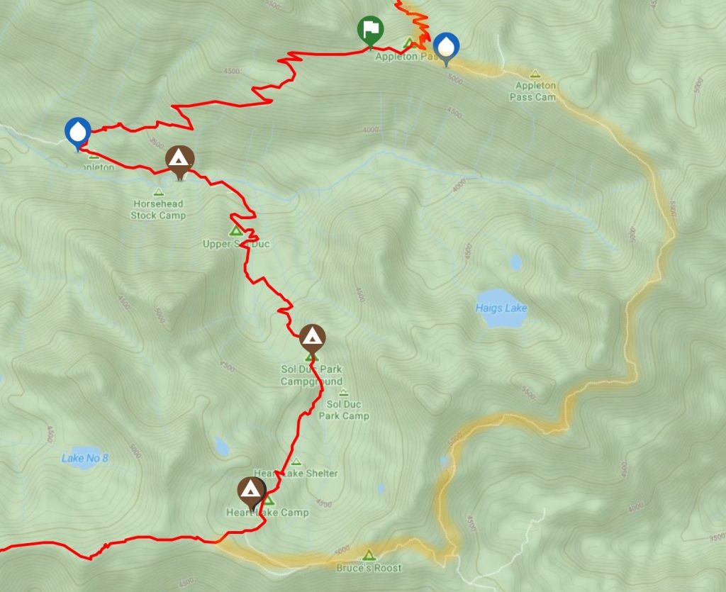
Days 53-55, Section 9, Olympic National Park Blue Alternates: Lost Pass to Grand Pass to Hurricane Ridge. Most of the notes and blogs I’d read suggested this route for the ample alpine exposure and great views. Plus it led to the Hurricane Ridge visitors center, where it was easy to get a ride into Port Angeles. I wholeheartedly agree that this was a great route…but only if a hiker’s ready for some serious kick-ass ups and downs. Lost Pass was a 1100 ft gain in 0.8 miles, Cameron another 1000 ft in a mile and Grand Pass 2260 ft in 1.6 miles! The views are worth it though, and this section ended up being my favorite of the park! The last 8 miles to Hurricane Ridge involved a dirt road walk with some traffic, but I found it pretty nice, easy, fast and still with good views. The next day, I had to take an alternate trail (Wolf Creek) down from the visitors center, because the park service was eliminating goats from the area. The Hurricane Hill Trail was closed, as a result. See the map of my route, highlighted in yellow.
Day 56, Section 9, Swimming Bear alternate from Appleton pass to just above Heart Lake: this is an unofficial alternate but fairly well-known trail. It stays high above the Sol Duc river basin, following along the ridges. It appears as light gray line on the FarOut map and is also a trail on the Hiking Project app. It was about the same distance but probably took longer because the views were great and the trail was a bit overgrown and steep in places. Add some extra time to enjoy Swimming Bear lake, or better yet, plan to camp at one of the few spots there…this takes a special request from park rangers-in-the-know, perhaps.
Some other lessons learned the hard way: In the wise words of Pippin, “short cuts make long delays” and road walking is almost always better than a bushwhack, even if the road is much longer. The FarOut comments are the best indicator…if they are lacking, it means no one has done the route in a long time and you probably shouldn’t either! I was very happy with all but one of my route choices…expect some mistakes but overall, stay positive and have fun! The PNT is a grand adventure!
Thank you so very much for posting this on the PNT page in FB, I never would have seen it otherwise. I have heard of you before (Cashmere spoke of you I think) but don’t think our paths have crossed. I’m starting to plan my PNT hike for 2023 and your information will be helpful. Thanks for taking the time to write this up, it’s really appreciated!!
Hi Kirk, You’re so welcome! I liked the PNT very much, so I’m happy to do as much as I can to help others have a good experience. That’s awesome that you have it planned!