05:45-18:30, Thursday, 5-21-20
CO 14ers: 6th (& 1st) of 53
Distance RT: 27 miles
Elevation gain/loss: 7600′
Start Elevation: 6,650′
Summit: 14,110′
Rank: 30 of 53
Location: Front Range, Central Colorado
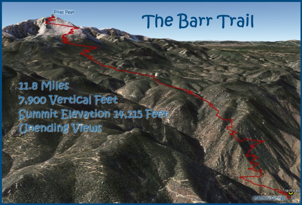
Route: Barr Trail, Class 1
Pikes Peak was the first peak above 14,000 feet (here on referred to as 14er’s) I ever hiked…but only halfway. Back in 2003, I went up with a friend and we got a ride down with my parents. Pikes Peak is one of two 14er’s in CO with a road all the way to the top (the other being Mt Evans and a 3rd, Mt Antero, has a road within a few miles of the top). At the time, it was the hardest thing I’d ever done. But now that I’ve graduated into a “professional” hiker, I thought it was about time I hike the mountain up and down, round trip. My reasoning is that this is the truest definition of hiking a mountain but really, I just needed a diversion and challenge from the other struggles in my life (explained in my 2020 update). Nothing like a 25+ mile day with HUGE elevation gain to start out the summer hiking season. Up to this point in the year, my longest hike had been around 20 miles, with almost no elevation gain. This was going to be a fun day (in a sadistic way), but I was really looking forward to it!
In the past 3 years, I’ve also hiked 6 other 14er’s. These were Mt Elbert (14,433′ 2nd highest peak in the contiguous US, 1/53 in CO) as part of the Colorado Trail (2017), Mt Whitney (14,505′ highest peak in the contiguous US) as part of the PCT (2018), and Grays Peak (14,270′, 9/53), Torreys Peak (14,2667′, 10/53), Mt Massive (14,421′, 2/53), and San Luis Peak (14,014′, 50/53) all as part of the CDT (2019).
Therefore, I’m counting Pikes Peak as my 6th Colorado 14er. That’s 6 out of 53 official 14er’s in the state. Some figures put the total at 58, which all depends on the official classification of peaks. According to 14ers.com:
To be ranked, a peak must rise at least 300 feet above the saddle that connects it to the nearest 14er peak (if another exists nearby). This guideline has been in use in Colorado for some time. The following peaks are not ranked because they do not fit this criteria, but they are on this 14er list because they are named and recognized on USGS maps:
Mt. Cameron – rises 138 feet above its saddle with Mt. Lincoln
El Diente – rises 259 feet above its saddle with Mt. Wilson
Conundrum Peak – rises 240 feet above its saddle with Castle Peak
North Eolus – rises 179 feet above its saddle with Mt. Eolus
North Maroon Peak – rises 234 feet above its saddle with Maroon Peak
With all that out of the way, let’s get to the hike already! For starters, I didn’t sleep very well the night before. I tried to go to bed early but just kept waking up…first at 1 am, then again at 2. Finally at 3:30 am, I gave in. My alarm was set for 4:30 am but an extra hour couldn’t hurt. I had a simple breakfast and drank coffee, leaving the door at 4:15 and seeing that light was just beginning to grow in the east.
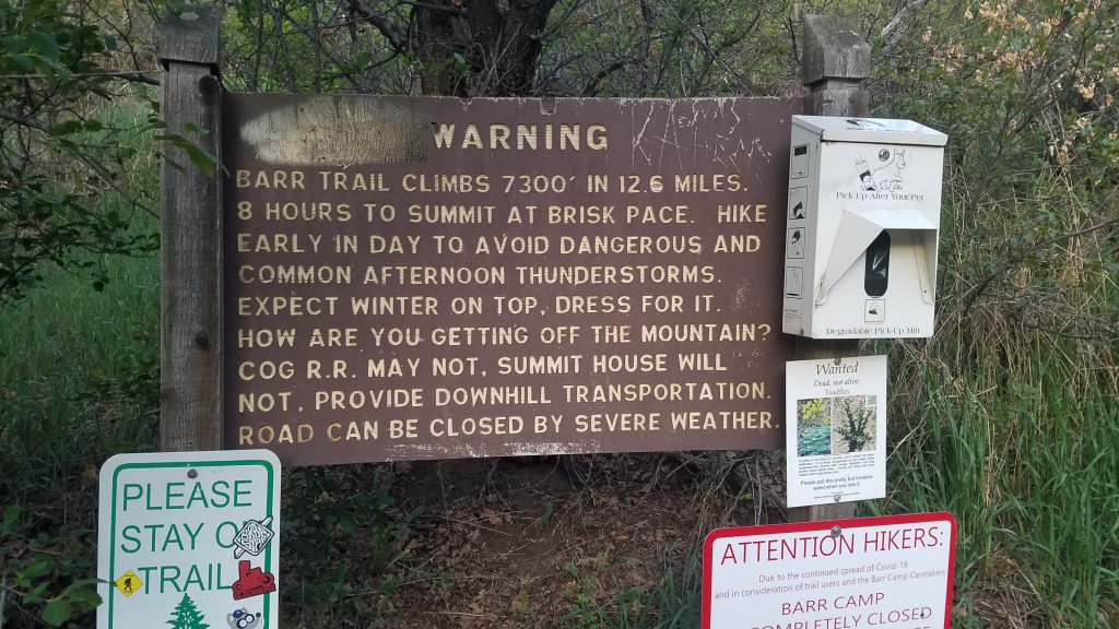
I drove to Colorado Springs in the dark, sipping my tea, watching the dawn grow. Just as I arrived at the trailhead, the first rays of sunshine were beginning to spread over the plains. I paid the parking fee ($10 for 1 day) and quickly set off. It was 5:45 am, an ideal start time for such a big day. The sign at the trailhead warned of the length and elevation gain: 13 miles one way and almost 7500 feet. For such a popular and historic trail, the figures vary widely. By numerous accounts, the trail is anywhere from 12 to 13.5 miles long and from 7300 to 7900 feet in elevation gain. There are 1/2 and 1 mile increment markers along the way, but these all seemed to disagree with other trail signage. Since my goal was just to get to the top and down, I didn’t much care about all the inaccuracies.
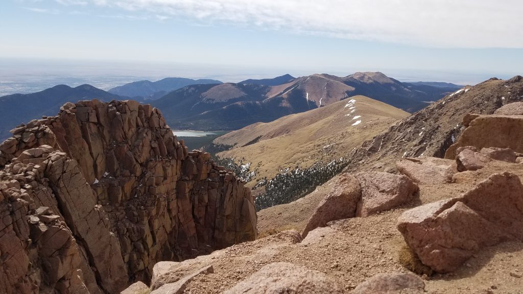
The first 6.5 miles to Barr Camp were a breeze. I ticked off the miles every 20 minutes, maintaining a fast 3 MPH pace, all uphill. I passed about 7 early-riser trail runners that were coming down and caught 3 hikers going up. The first 3 miles of the trail switchback like crazy up Manitou Mountain. Then the trail levels off a bit along a steady ridge, with excellent views of the monstrous peak looming in the distance.
Barr Camp sits at the base of the massif. It’s a good stopping point for people doing an overnighter…there are even cabins for rent…in a normal year. Barr Camp was closed at this time, due to the Coronavirus. I stopped briefly to read some of the signs iterating how I would die if I continued on without a plan to get down. High elevation summits always have the potential for getting a bit dicey, even in summer conditions. But I knew I had an excellent weather day, was carrying some layers for the cold, and most importantly, could depend on my plan to have my feet carry me back down the mountain. After over 10,000 miles hiked, I have a lot of confidence in my feet.
I started up more switchbacks for 3 miles towards the timberline. Reaching the 11,000′ elevation mark, I really started to feel the altitude and consequently slowed down. I even experienced a moment of dizziness and a tight chest. This gave me some concern and I even considered turning back. Back in late November of 2019, I had a bit of a health scare. After completing 3,500 miles over the season along the CDT and AZT, and feeling invincible, I was diagnosed with a life-threatening condition. I suffered through weeks of debilitating headaches and nausea (including 5 days in the Miami VA hospital, where they took good care of me). Luckily I did not experience any long-term disabilities. If there’s a silver lining, my normal migraine headaches have been significantly reduced since all this.
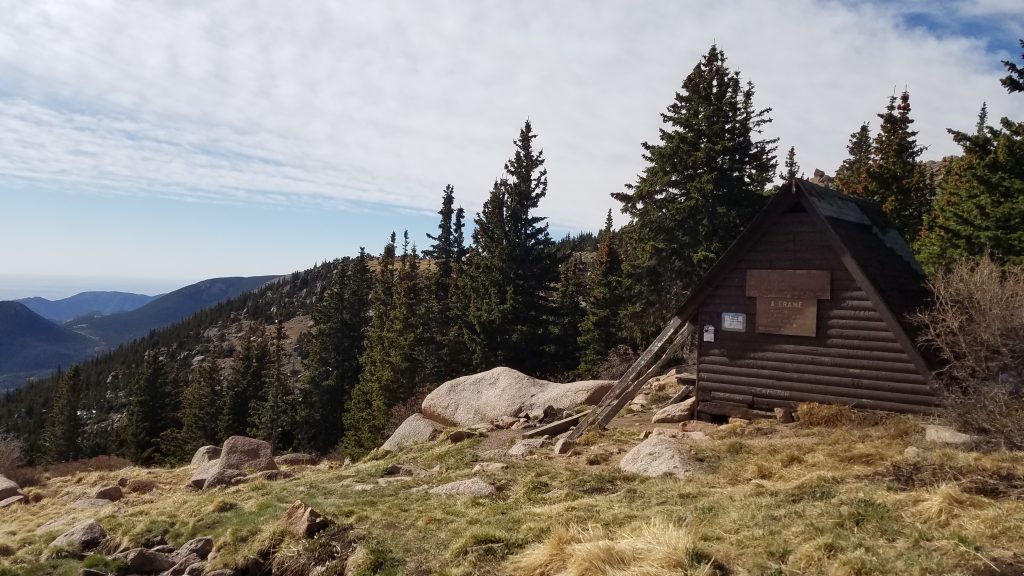
The neurologists suspected that all the high-altitude hiking I did over the summer and fall might have contributed to my problem. And here I was, attempting another 14er. Should I keep going, knowing that I might make my condition worse? This was weighing on my mind as I caught up to another 2 hikers that had just left Barr Camp. Seeing other intrepid people (and still being able to pass them) encouraged me to continue on. I reached an A-frame shelter at timberline and took a much needed break. It was still 3 miles to the summit but it looked so close! Only another hour or so I figured, which would have put me up there by 10:30 am. I would’ve be happy to arrive by 11 am.
The other 2 hikers caught up, took a break near me, and we chatted for a bit. It was sunny and peaceful, with a beautiful small stream running through the meadow. Marmots scurried all about. I could just sit and watch them all day. They twirl their long bushy tails when they run, which is mesmerizing and hilarious to me. The solitude was periodically shattered by loud clangs and bangs from the summit. A new summit house was being built and we could hear the construction activities from 2,000′ below. Finally I continued on, hitting the 10 mile mark by 10 am…which is always a satisfying mark.
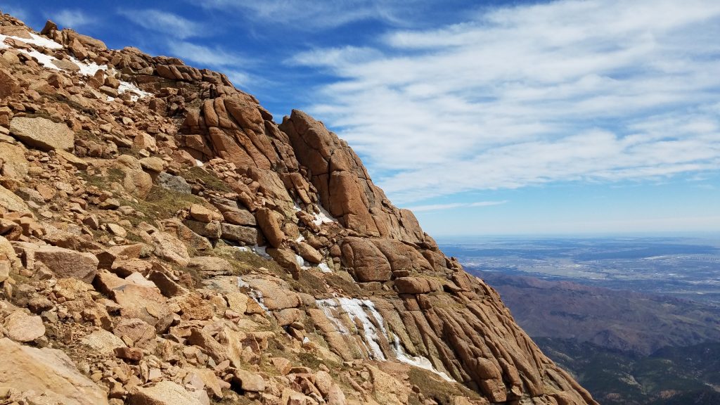
Oh, but did the last few miles kick my butt! Above 12 or 13,000′, it gets real. At first I was distracted by hiking through giant boulder fields. The lower slopes have some astounding geology. Plus the views above timber are fantastic! I also hiked through a few small snow fields…another fine distraction. But then I kept looking up, seeing the summit that never seemed to get any closer. Grand switchbacks stretched into the distance so I narrowed my focus on each turn. Three guys stood out ahead and that gave me another goal…catch them. So I did.
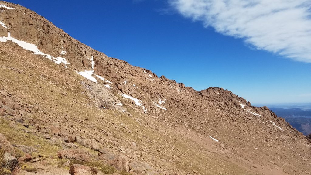
With a mile to go, my breathing was labored and my head was spinning. I was also feeling nauseated…altitude sickness was setting in. I took many small breaks, pondering the marmots and views. I entered the area known as the 16 Golden Stairs. A stair refers to a set of switchbacks…one left hand and one right hand combined. I did not bother keeping count as I ascended…my pace was too demoralizing. This is the most difficult section of the trail, as it goes through some very steep terrain. Melting snow had made many little streams across and down the trail, which were still frozen. Navigating snow fields is one thing but ice is treacherous. I had to pick my way along very slowly…which was just fine since slow is all I could manage.
A few hundred feet from the top, I encountered a guy who gave his name as Lucifer…I had just given my trail name as Twig, of course. I stopped to chat with him for a bit. He had started up the trail from the bottom at 2 am and had already been to the top. He admired my tiny day pack, since he appeared to be carrying quite a bit more than me. I admired his foam mattress pad, which he lounged on in comfort. The break did me good, as I was able to complete the final stairs easily.
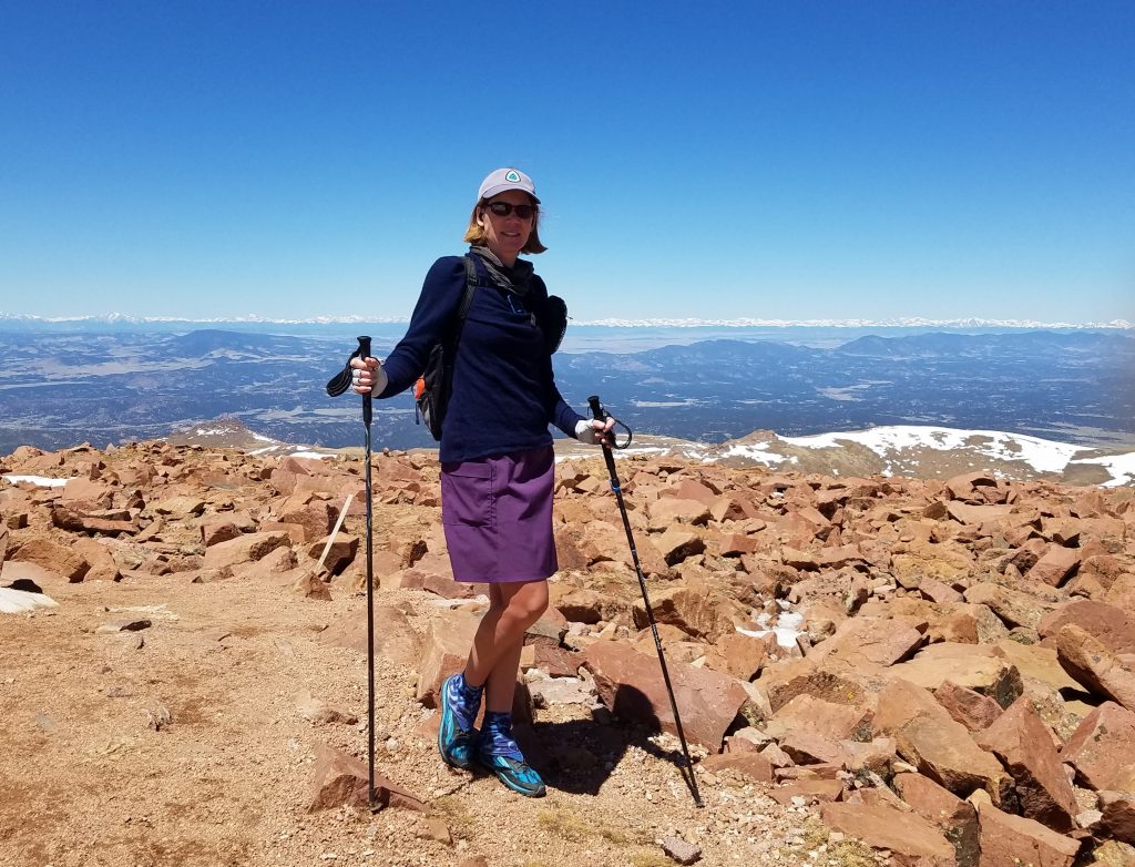
Reaching the top was the most anti-climatic mountain climb yet. I was greeted by a chain-link fence, diesel smoke, and a giant construction scene. So ugly and off-putting. A sign on the fence instructed me to go all the way around and down a couple hundred feet in elevation until I came to the highway, then hike back up to the summit. This added almost a mile to the trip and it was a mistake to go any further from this point. I saw the road way down below and opted to traverse along the scree slope to make my way around. I boulder hopped and scuttled along another 30 minutes before I made it to where the road joined, then following the exhaust of the tourists driving up. The “top” was a disappointing scene, chaotic and confusing due to the construction. I never even found the summit mark, which may have been swallowed by orange fencing. Oh well. I made it and I earned it. Now to get down.
It was high noon by now, well past my estimated times of arrival at the summit. Given all the unnatural activity and that fact that I was feeling like crap from the elevation, I just wanted to get back down a ways to take my lunch break. I reckoned that the peaceful meadow near the A-frame was a good goal. But the more I went down, the more I felt like crap. I could feel a migraine coming on. I realized that I had not drank near enough water and chided myself for not doing better nutrition and hydration wise. I did feel a little better after my break at the A-frame but also knew I still had a very long ways to go to get back to the trailhead. Almost 10 miles, in fact.
I buckled down, immersing myself in thought about whatever podcast was playing at the time. The miles ticked by and I passed more and more people, some out for a day hike and others with overnight packs. Aside from Lucifer (who I saw still sitting in the same place on my way back down), I think I was the only one making the round trip on this day. The cruise along the ridge was pretty effortless but I felt nearly depleted by the time I reached the switchbacks on Manitou Mountain. A call from a friend with 2 miles to go gave me the jolt I needed…she informed me that my mom had been in a car accident. It was a bad ending to a pretty good day but at least my mom wasn’t hurt. There was nothing more I could do but finish the hike and rush home. This day definitely was one of the hardest I’d ever done but at least I could finally put to rest my status with this mountain. I climbed Pikes Peak.
I staggered across the finish line with a passing thought: man, I should not do that again for a very long time. Little did I know I had 19 more in store for this summer…