Thursday, Sep 7th, 2023, 0640-2030
Watson Lake to Galena Falls, +side trip to Mt Rose.
30 miles, Gain 6600′, Loss 5320′, elevation 9050′
It was a slow build up to a big finale kind of day. The morning was pretty easy but nothing too exciting. I passed through an active logging area and saw a chainsaw sitting on the side of the trail, unattended. I could have practiced my sawyer skills. I caught up to Silver Bullet mid morning and we stopped to chat. I would have liked to hike with her but she was taking it slower, getting back into the swing of things. I planned my food carry based on my higher mile days, so our schedules didn’t really align. Still, it was great to see her again.
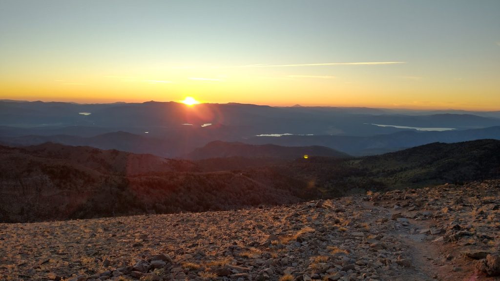
The trail went up up up for many miles, reaching the TRT highpoint at 10,335′ on Relay Peak. I stopped just before then to have some lunch and collect water. There were so may views along the way, both of the lake and the surrounding mountains. I could just make out Lassen peak at over 100 miles away. I could also see Sierra Buttes and the whole ridge of mountains I hiked along through Granite Chief Wilderness, south of Donner Pass. I crossed the Nevada/California state line and officially took my first hiking steps in Nevada. Before this year, I’d never hiked in Utah or Nevada. Now I’d done about 600 miles through Utah and Nevada remained an enchanting realm of high, desolate mountains waiting to be explored. The 60 miles on the TRT barely scratched the surface, but were a start.


There were also lots of day hikers and a few mountain bikers. I entered the Mt Rose wilderness, which was clearly posted as being off limits to bikes, but still I encountered 4 mountain bikers. They looked like they were on vacation and so maybe just oblivious to the rules. Everyone was very courteous and friendly, so it was no big deal. I didn’t reach Relay Peak until later in the afternoon and by then I was beginning to doubt if I could do the side trip up to Mt Rose, as I had hoped for. I took an alternate down from the peak, an old road that used to be the TRT. It shaved about a mile, buying me some more time.
I reached Galena Falls, the junction for the side trip, and saw the sign said 3 miles to the Mt Rose summit. It was farther than I thought, so I decided I would set up my camp first and then see how I felt. My tent and bag were a bit wet with condensation from the night before, so I needed to at least get them aired out before it got dark. I went half a mile up the side trail and found a stealthy spot under a pine, next to the meadow. I doubted anyone had ever camped there before, something I loved about finding my little obscure spots. I began setup, making a pact that if I finished before 6 pm, I’d allow a hike to the summit for sunset. If it was later than that, I’d get up first thing in the morning and do it then. I’d already hiked 24 miles this day, so that should have been good enough. Why I still wanted to push an extra 6 miles and 1500′ of gain, well, that’s just the way I am when I get a thing stuck in my head. But the much smarter and safer move was the sunrise summit.
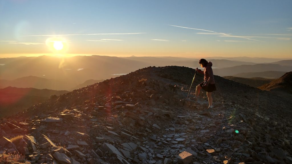
I got everything set and checked my watch: 6:05 pm. Heck yeah, close enough, I was going for it! I grabbed my headlamp, PLB, jacket and one trekking pole and took off. The only thing I regretted leaving behind was my other trekking pole…it was unfortunately needed by my tent. Without a pack, I flew up the trail. It was steep and my legs felt pretty tired from the already arduous day, but I was determined. The trail went up a gully, gained the ridge, and began a series of switchbacks up the flank of the mountain. Breaking free of the treeline, I began to feel the wind. It picked up significantly as the evening approached. I passed a couple that were still headed up, then another guy on his way down, just shy of the summit. Seeing a few others made me feel better about my decision to head up so late…I wasn’t the only crazy one.
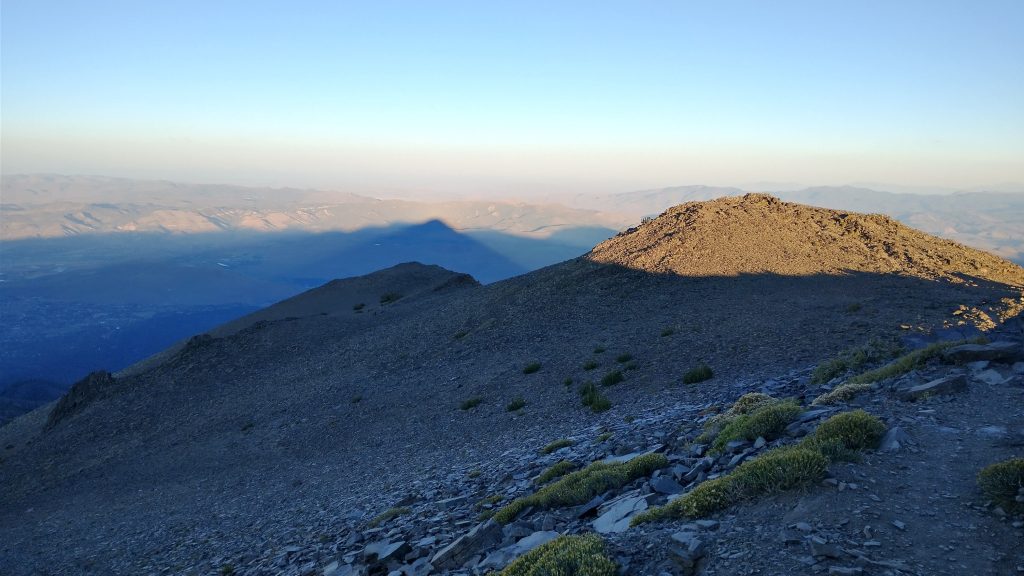
The last few switchbacks revealed the full force of the wind. It almost blew me over several times. Having only one trekking pole was barely enough to keep my balance, plus I had to keep grabbing onto things before they flew away: my hat, my buff, my sunglasses even. Everything ended up either zipped into my jacket pockets, my fanny pack, or clipped onto my body. The wind became bitterly cold pretty quickly, too. I wished I had more layers, but I also didn’t plan to stay long, just long enough to confirm my suspicions.
By now, readers probably know that I have a passion for peakfinding and geography, in general. It’s a fun practice, but also very applicable in sharpening navigational skills. It’s actually crucial in terms of being able to triangulate a position. When I hiked the PCT in 2018, I saw a man on the steps of the Mt Hood Lodge, pointing south towards Mt Jefferson, but telling his son that he was viewing Mt. St. Helens. It was the wrong direction, wrong shape, and wrong state entirely. I was dying to correct him but knew from my years spent in male-dominated positions, such confidence was hard to overcome, especially coming from me, a woman. So I kept my mouth shut and felt sad about the next generation growing up just as geographically-challenged.
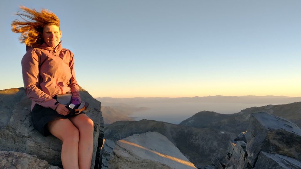
Recently, a guy at the Donner Pass bar had claimed that he could see Mt Shasta from the top of Freel Peak, at the very south end of Lake Tahoe. This assertion was somewhat plausible, but I highly doubted it. I suspected he had Shasta confused with Lassen, the latter I was pretty sure was visible at least from the north side of the lake. I’d already seen it earlier this day, so I knew there would be an even better view of it on top Mt Rose. Perhaps Mt Shasta was viewable from Mt Rose, too. If so, it would be quite a feat, at nearly 200 miles away. I just had to go see for myself. Well, Peakfinder said no and I could not see anything, either. So that settled it. Still, I was very happy see Lassen, perhaps for the last time this trip.
Speaking of volcanoes, Mt Rose was thought be an extinct volcano. At 10,777′, it rivaled Mt Kulshan (Baker), which I climbed around this time the previous year. This summit was much easier, as it didn’t involve glacier travel. I headed down just as the sun was sinking behind the ranges. I marveled at the fact that I could see the course of the PCT I’d traveled from Lassen all the way to south of Echo lake…hundreds of miles. What a brilliant way to end the day, reflecting on this amazing journey and the fantastic topography of this region.
I didn’t need to turn my headlamp on until the last 3rd of the trail down. But it was a good thing I brought it since I needed to go cross country a bit to get back to my tent. One of the challenges of a camouflaged tent is that even I can have a hard time locating it in the dark. Luckily I took note of several landmarks and even dropped a GPS point just in case. Earlier on the ascent, I’d looked back and could just see it under the tree. It was actually in plain sight of the trail, but if you didn’t know what you were looking for, you’d never know it was a tent. I found it with no problem and quickly put on my layers. This was one of my highest camps yet and it was already pretty cold. The wind continued to blow, but thanks to my surrounding trees, the gusts barely reached me. It was so nice to already have everything setup, all I had to do was make a hot meal and go to bed. As I was eating, I saw the headlamps of the people I’d met at the top. They were coming down but still had a long ways to go to the campground. I was most grateful for my backcountry site at the base of the mountain.
Hi Leah!
I love keeping up with your adventures! You are a remarkable woman. I’m amazed at your progress! Continued success to you on your trip, it was such a pleasure spending time with you in July.
Sincerely, Meryl
Hi Meryl, it was an honor to meet you ladies…seems like so long ago and so far away. I’m so glad you have been able to follow along!