(Scroll to the bottom for a links listing of all my daily blogs)

What! Another thru-hike? Right after the Te Araroa? Yes, I just couldn’t get enough.
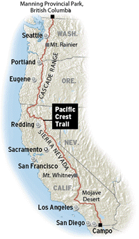
In July 2018, I began my SOBO hike from Canada to Mexico. I finished at the end of October. The was perhaps the most perfect thru-hike I’ve ever done. It all just went so smoothly and was so much fun. I plan to hike the PCT again someday, just to relive some of the wonderful moments. Of course it will never be the same again but that’s ok. This is a hike worth repeating.
PCT Facts:
- Location: California / Oregon / Washington, USA
- Length: 2,652.5 mi (4,269 km)
- Time Zone: PST (UTC-8)
- Northern Terminus: Canadian Border
- Southern Terminus: Campo, California
- Highest Point: Forester Pass, 13,153 ft (4,009 m)
- Lowest Point: Cascade Locks, 140 ft (43 m)
- Elevation Change: 420,880 ft (128,284 m)
- Use: Pedestrian & Equestrian
*It’s now illegal to cross the Canadian Border to continue to Manning Park Canada. As a SOBO, I had to start my hike at the nearest US trail intersection, a place called Harts Pass. I hiked an extra 30 miles north, then retraced my steps. What’s an extra 30 miles when already walking 2650?
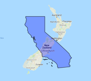
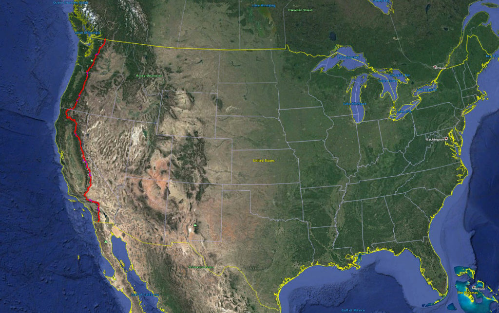
How does the PCT compare to Te Araroa (my previous thru-hike)? Well, it’s about 800 miles longer, for starters. Check out the size comparison of the state of California to the country of New Zealand. They are about the same length but California has twice the land area and about 33 million more people. The PCT also involved walking the length of Oregon and Washington State.

Since the condition of the trail on the PCT is generally excellent, I was able to do many big mile days, averaging more miles per day and finishing in 4 months. That means I hiked the entire PCT in about the same amount of time as the TA.

Here’s a list of all my posts relating to the Pacific Crest Trail. Clink on any of the links to open the post.
PCT planning
PCT Day Zero: The return of serendipity
PCT Day 1: Bring it on
Day 2: The Border
Day 3: First Full Day SOBO
Day 4: An unexpected town stop
Day 5: A mountain marathon
Day 6: The first official town day–Stehekin
Day 7: Escaping town
Day 8: Flying high
Day 9: Up and down around Glacier Peak
Day 10: Still around Glacier Peak
Day 11: Rolling along
Day 12: Escaping the bugs
Day 13: Onto the Next Section
Day 14: Beautiful Waptus River
Day 15: Magical Mountain Moments
Day 16: I-90
Day 17: A productive day for a Sunday
Day 18: A Hut!
Day 19: A little of Everything
Day 20: Good beginnings and endings
Day 21: The White Pass Vortex ends in a Nero
Day 22: Goat Rocks Wilderness
Day 23: Not Goat Rocks Wilderness
Day 24: Trail Magic and Town
Day 25: Trout Lake is Great!
Day 26: Huckleberries and Mt Hood!
Day 27: Last full day in WA
Day 28: Oregon!
Day 29: First Zero
Day 30: Back on the trail
Day 31: Oregon is not Flat!
Day 32: Summer Skiing
Day 33: Taco Tuesday
Day 34: Mt Jefferson
Day 35: Hot lava
Day 36: Bend
Day 37: A Record Day
Day 38: Another hut!
Day 39: Shelter Cove
Day 40: A missed meetup
Day 41: Highpoints and Smoke
Day 42: Mazama
Day 43: Rolling along
Day 44: Some more lava but not much water
Day 45: Almost there
Day 46: Ashland
Day 47: California
Day 48: Smoke
Day 49: The State of Jefferson
Day 50: The next thousand
Day 51: Etna
Day 52: Slimy Salamanders
Day 53: A bear
Day 54: Deadfall lake
Day 55: Castella
Day 56: Skirting the fire
Day 57: Rolling hills in NOCAL
Day 58: Burney Falls and Mountain Guest Ranch
Day 59: Hat (hot) Creek Rim
Day 60: Lassen Volcanic National Park
Day 61: Halfway
Day 62: Belden
Day 63: Quincy
Day 64: Back in a Bubble
Day 65: Around Peaks
Day 66: Sierra City
Day 67: Getting Higher
Day 68: Nearly Blown Away
Day 69: More Wind
Day 70: Desolation Wilderness
Day 71: Gearing up in South Lake Tahoe
Day 72: September in the Sierra
Day 73: Bluffs and Pinnacles
Day 74: Sonora Pass
Day 75: Under 1000 and Entering Yosemite NP
Day 76: Bonks and Bears
Day 77: Tuolumne Meadows
Day 78: Donohue Pass
Day 79: Reds Meadows
Day 80: Two Passes
Day 81: Muir Pass
Day 82: Mather Pass
Day 83: Three Passes
Day 84 & 85: Bishop Zero and Nero
Day 86: PCT Highpoint – Forester Pass
Day 87: Mt Whitney
Day 88: The final push through the Sierra
Day 89: Kennedy Meadows South
Day 90: 700 miles to go
Day 91: Walker Pass and Ridgecrest
Day 92: Ridgecrest Zero & PCT Party
Day 93: Into the desert
Day 94: Wind Farms and Forest
Day 95: Tehachapi
Day 96: a SOBO bubble in the desert
Day 97: Survivor SOBO
Day 98: Under 500
Day 99: Hiker Heaven
Day 100: The Race to the Finish Line
Day 101: The PCT Hiker Fan Club
Day 102: Wind and Cold
Day 103: Cajon Pass
Day 104: A lake and creek
Day 105: 300 Miles
Day 106: Big Bear in and out
Day 107: Whitewater Preserve & Oasis
Day 108: Up, Up, Up
Day 109: Idyllwild
Day 110: Muirwood
Day 111: A Big Day
Day 112: Eagle Rock
Day 113: Mt Laguna
Day 114: The Penultimate Steps
Day 115: The Finish
PCT Summary & Stats
Bonus PCT blogs from 2023:
The Pacific Coast Bigfoot Crest Rim Trail Introduction
PCBCRT Day 33: Bigfoot Meets the PCT
PCBCRT Day 34 & 35: Seiad Valley Vortex
PCBCRT Day 36: Running up that Hill
PCBCRT Day 37: Marble Mountains & Unplanned Town Stop
PCBCRT Day 38: The Russian Wilderness
PCBCRT Day 39: Packers Peak Bigfoot Trail Highpoint
PCBCRT Day 40: Trinity Alps
PCBCRT Day 41: Off Script & Much In Motion
PCBCRT Day 42: On Cruise Control
PCBCRT Day 43: When Fires Start to Burn
PCBCRT Halftime Report PCT Days
PCBCRT Day 44: Out of the Heat
PCBCRT Day 45: Grizzly Peak Bagging
PCBCRT Day 46: Burney Falls
PCBCRT Day 47: The Rim
PCBCRT Days 48 & 49: Lassen and Chester
PCBCRT Day 50: Into the Burn
PCBCRT Day 51: Thru Belden
PCBCRT Day 52: Super Blue Moon
PCBCRT Day 53: Always a Hard Day
PCBCRT Day 54: September Storms
PCBCRT Day 55: The Delicate Dance Between Wet and Dry
PCBCRT Day 56: Hut to Ski Lodge to Hut
PCBCRT Day 57: Starting the TRT
PCBCRT Day 58: Tahoe City
PCBCRT Day 59: The 2nd Start of the TRT
PCBCRT Day 60: Mount Rose
PCBCRT Day 61: Crushing on Crushed Granite
PCBCRT Day 62: South Lake Tahoe in and out
PCBCRT Day 63: Around Freel
PCBCRT Day 64: Half Day
PCBCRT Day 65: Dicks Peak
PCBCRT Day 66: The Homestretch
PCBCRT Day 67: I Just Can’t Get Enough
PCBCRT Day 68: Wolves or Huskies?
PCBCRT Day 69: Sonora Peak
PCBCRT Bonus Hike: The Pinecrest Loop Trail
PCBCRT Summary and Stats
And 2025:
Introducing the Desert Winter Thru Hike
DWTH Day 41: Whitewater Preserve & the PCT
DWTH PCT Days 1-13: Mexico Border/Campo to Whitewater Preserve
DWTH PCT Days 14-25: Whitewater Preserve to Acton
DWTH PCT Days 26-39: Acton to Kennedy Meadows South
DWTH, SDTCT & PCT Desert Section Summary & Stats
Pacific Crest Trail 2025, Round 2
2025 SOBO PCT Days 0-6: Ross Lake to Canada to Stehekin
2025 SOBO PCT Days 7-15: Stehekin to Snoqualmie
2025 SOBO PCT Days 16-24: The 2nd Half of WA
2025 SOBO PCT Days 25-34: Cascade Locks to Shelter Cove Oregon
2025 Pacific Crest Trail Days: Back to Cascade Locks
2025 SOBO PCT Days 35-42: Willamette Pass to Ashland
2025 Sierra High Route Days 0-5: Sonora Pass to Tuolumne Meadows
2025 Sierra High Route Day 6: A Side Trip To Half Dome
2025 Sierra High Route Days 7-9: Past the Ritter Range to Reds Meadow / Bishop
2025 Sierra High Route Days 10-16: Bishop Pass to South Kennedy Meadows
2025 Sierra High Route Days 17-22: Bishop Pass to Mammoth
2025 Summer/Fall Summary & Stats, Year In Review
