Sunday, August 14th, 2022, 0620-1920
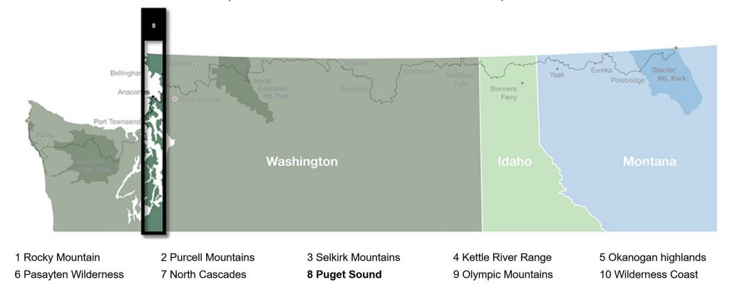
FR 313 to HWY 9, WEBO mm 913.6, Section 8 Puget Sound
32 miles, Gain 4580′, Loss 6920′, elevation 280′
I’m calling this day the official start of the Puget Sound section, because I had the first and most awesome views of the sound and also because it was almost all road walking all day.
My crappy tent site proved to be one of the worst when I woke to a ton of condensation. But at least it was very quiet. No vehicles came by and I didn’t even hear a noise…well save for one: the honking or barking noise of some still unknown animal. It’s something I hear all the time but last night was especially prevalent. I used to think it was the bark of a deer but this night the barks surrounded me and kept coming from all different directions and distances. Some bird crowing, like a peasant perhaps? I still have no idea. It’s one of the unsolved mysteries of my hiking career.
I hated packing my wet tent. I would need to dry it at lunch…yet another chore. It was nice watching the sunrise as I walked the logging road. Of course I spotted a bunch of campsites that would have been much better than where I stopped. Oh well. I should have pulled up my Locus app map to see how many roads were jutting off the main one, each providing discrete opportunities. The FarOut map doesn’t show any of the logging roads, so it’s always a guess as to which one to take. Usually it’s the main raod but not always. Sometimes there’s also PNT markers or little wooden signs. I even saw where someone painted white blazes at certain intersections. But generally I just had to start down a road and keep looking at my blue dot to make sure it was tracking correctly.
The FarOut maps are kind of terrible…so is the entire guide for this trail but it will get you by ok. It helps to have a few other mapping apps. The Locus map is far better because it actually shows the PNT route (though it’s changed in a few places) plus all the roads. I purchased the Locus map for less than a dollar and the add-free silver subscription is about a buck fifty a month. FarOut’s greatest assets are the user comments that it’s customers give to it for free (to benefit our fellow hikers). They should be paying us, not the other way around. What a business model: put a crappy product out there for the public and the paying customers will make it much better for you for free. You’re welcome, FarOut…not that you care. Still, I’m glad for most of their guides.
I came back to the red line after an hour or so. I had to take a purple line reroute due to logging activity around Mt Josephine. Nothing was going on during a Sunday it seemed, so I probably could have taken any route. I then came up behind a camo man carrying a tripod and crossbow. It gives me a little trepidation meeting such tough looking people alone in the woods but they’re usually nice. He was walking the same direction, thus I was coming up behind him, unseen. I made sure to call out early, lest I startle him. He did start to raise his bow, even so, but quickly gave me a smile and asked if I was hiking the PNT. I think he may be the first I’ve met on trail, other than fellow PNT hikers, to get it right! I asked what he was hunting and he said bear season had started Aug 1st. All the more reason to not worry about bears bothering me. For one, they’ve got plenty to eat with all the ripe berries and two, they’re already running scared with hunting season starting so early. No wonder the one I’d seen the night before was gone in such a flash.
This man would be the only person and vehicle I’d see all day…at least until I got to HWY 9 at the very end. I actually really enjoyed this day, simply because it was so quiet. And also because the views were pretty great later. But first I had to descend towards the valley. This took most of the morning. I had service so I made phone calls. I also contacted a trail angel, Mary Walker, to let her know I would be arriving the area in a day and ask if it was ok to stay. She responded right away saying yes. I was so excited to visit. She lives on a lake and has paddle boards…heck yeah! Stories about her place from previous hikers were legendary.
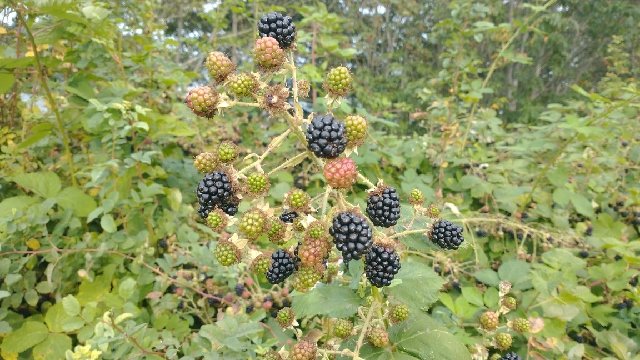
I came to a section that was supposed to be one of the last bushwhacks. Here, an alternate broke off to head for the valley and a rail trail that ends in Sedro-Woolley. Previously, I thought I might take the alt but now I didn’t want to bother with the logistics of getting back to the trail from town. I’m so glad I took the main route because of the views and peace and quiet. But I’d been fearful of the small bushwhack because of all the comments about blackberry thickets. Sie So, a hiker I met on the AZT and who I have a lot of respect for (he was a marine and now is a wildland firefighter=badass), left a comment saying the bushwhack “had taken a piece of his soul.” All his other comments pretty much described the rest of the trail as easy, so he’s not one to exaggerate or complain.
Fortunately it was easier than expected, mainly because it was so short…about 3 tenths of a mile through the thickest stretch. But I had to take it really slow, basically using my trekking pole as a machete to hack my way through the encroaching blackberry tendrils. They reached like octopus tentacles across the makeshift path, ready to ensnare a hapless hiker. I found that the branches bent easily when hit with my pole, changing their angle so I could pass. But I needed space to be able to swing, so I found myself backing up numerous times to attack a branch I hadn’t previously noticed until it was in my face. The trick was not to keep pushing forward if one latched on…you’d just continue to become ensnared, getting ripped to shreds. Best to back up, dis-entangle the tendril gently, then hack at it like mad. Human Twig goes to battle with her arch nemesis…the blackberry twig.
I did get pretty entangled once. A tendril had both my feet bound, and another had my shoulder and arm. While pausing to figure out my escape, I spotted a bounty of ripe berries. With my one free hand, I harvested the find, coining the mantra: if you can’t beat em, eat em. This gave me an odd sense of satisfaction, as if I was exacting my revenge. Haha, take that. I kept a good attitude throughout the ordeal, even laughing a couple times. The brambles were one thing but there was a spot around a creek with a bad washout and steep side wall, then some sketchy sidestepping on a slope. I was confused by this since I was supposed to be following an old road bed. I guess it had been completely washed away in this one spot. I was only worried about sliding into the bushes, lest I become hopelessly entangled with no one around to help extricate me. But I made through the whole thing surprisingly unscathed. Whew.
The rest of the my morning and most of the afternoon was spent ascending a logging road. Not one vehicle had passed me since the bear hunter. I enjoyed the solitude, breaking for lunch beside a stream and drying my tent. More uphill led to some great views. I looked back to catch glimpses of various peaks in the Cascades, including the volcanic massif of Glacier Peak. I’d hiked around that mountain as part of the PCT. I also had wonderful views of Puget sound, all the way from the south around Seattle, to the Olympic Peninsula, then Whidbey Island and Anacortes, the San Juans islands and finally north to Vancouver Island, the Vancouver city area, and the surrounding Canadian mountains. What a sweep! I couldn’t yet see Rainier but later had great views of Baker, so a 2 volcano day ain’t bad. And if you can believe this, I think I actually could make out a few of the skyscrapers from the Seattle skyline. It reminded me of seeing the NY City skyline from the AT and LA from the PCT. So cool.
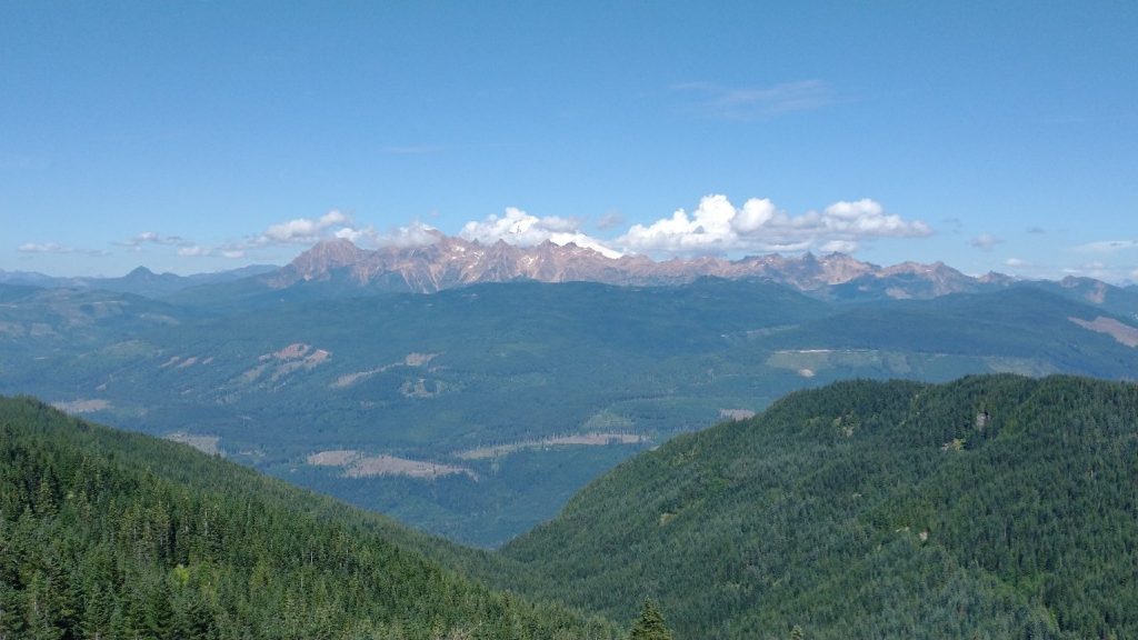
The route stayed high along Lyman hill, following a ridge. I walked between clear cuts and forest, enjoying the views. I tried to take some pictures of the sound but the large distances didn’t lead to good photos. I settled for a good picture of Mt Baker with the rusty miner peaks in front. I grabbed water from a stream for the night, since notes said to avoid the river in the valley. Many road switchbacks led me down down down. I passed up a few ok campsites, just wanting to get a few more miles done. I entertained the idea of doing a bit of the highway walk, hoping it would be quiet on a Sunday. It was not. I went only a quarter of a mile before retreating to an old railroad bed running alongside the highway for a short spell. The light was fading and I figured it best to tackle the road in the morning. Where to camp among the farms and solid private property signs? The railroad peeled away from the highway and I had an inkling. I followed it just out of sight and found a flat spot near a cedar tree. There was a fence across the railroad bed, so I knew it wasn’t currently active. A fox came by as I was setting up, so I knew I was in somewhat of a wild and quiet spot. Hobo camping 101.
“If you can’t beat ‘em, eat ‘em”….OMG, I love you! Hike slower and write faster haha! I’m addicted.