Sunday, Aug 13th, 2023, 0700-1840
Big Flat Campground to Stuart Fork Trail
20 miles, Gain 3730′, Loss 5300′, elevation 3250′
I think this was the most quiet campground I ever stayed at. The night before, I was able to porky-pig (top but no bottoms) my way around my campsite until I dried off from my creek dunking…. that’s how quiet it was. I didn’t even see or hear people until I was on my way out in the morning. As a result, I slept like a rock. Actually, I slept behind a big rock too, concealed from the world in my rock-like tent…it blended in so well.
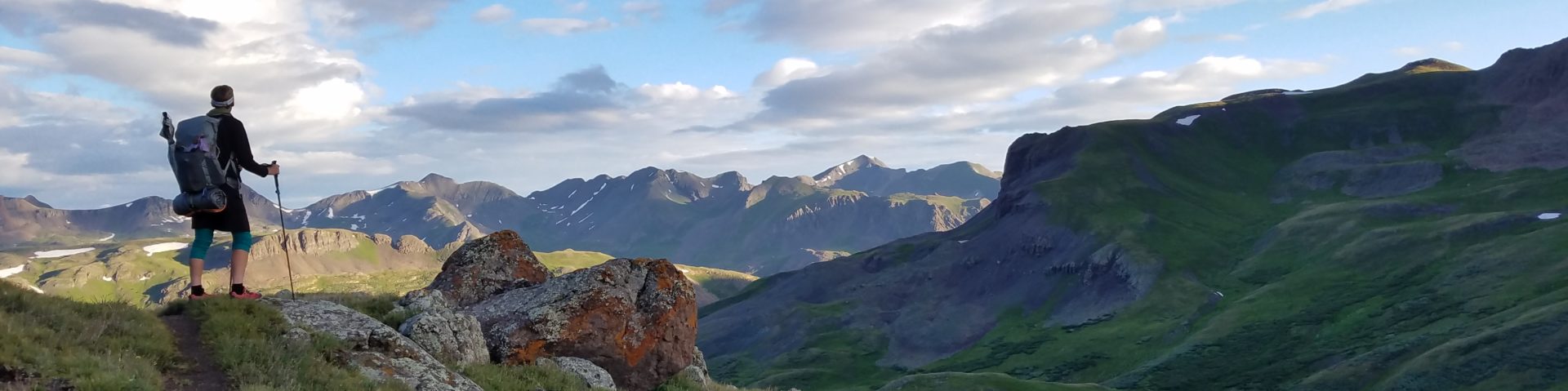
The river valley was a refreshing 55 degrees as I set off…perfect for another big climb. Unfortunately it didn’t last. As I began the switchbacks and entered a burn area, my thermometer read 80 degrees by 0730 am. Not good. The trail was immaculate, at least, since it was heavily used to get to the Caribou lakes. I passed several groups of 4 to 8 backpackers that were leaving, plus there were plenty more still camping. Despite the temperature, it was a pretty easy climb with great views all the way. I was able to stare back at Packers Peak, which didn’t look as steep and high from far away.
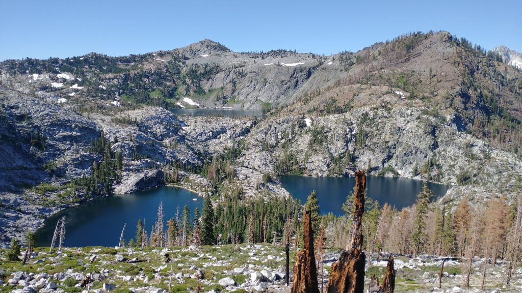
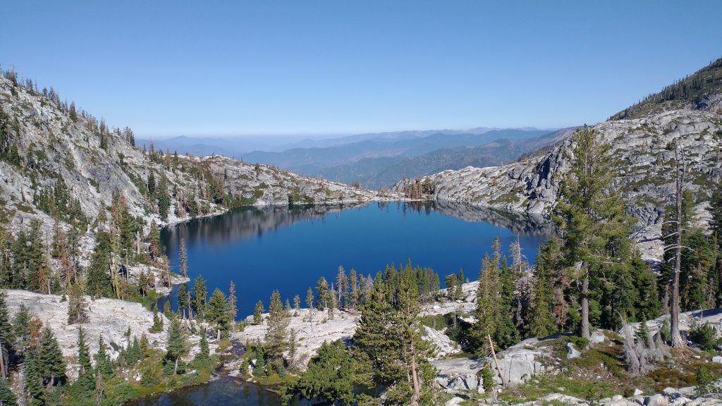
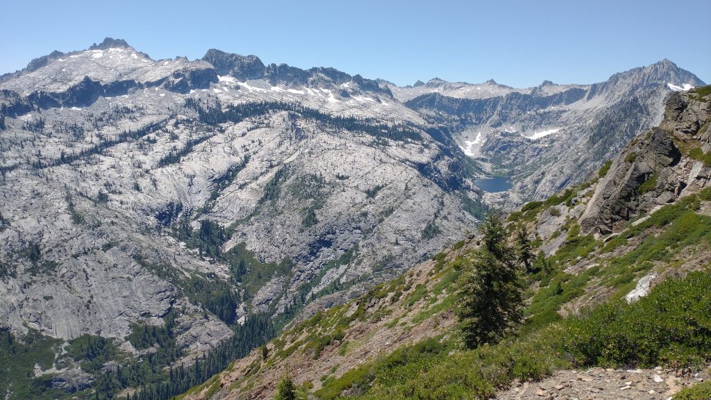
I reached the clear blue lakes just in time for an early lunch and mid day swim at the upper lake. The water was so incredible, and not even that cold considering all the snow drifts that were still around. Nature’s swimming pool. It was a good idea to soak my clothes before I began the last bit of the climb to the ridge above the lakes, since it started to get hot. The trail was easy to follow and shortly I was on top, looking down at one of the most gorgeous valleys I’d ever seen. To the right was Emerald lake and Sawtooth mountain at nearly 9000′. The massif of granite was quite impressive, looking as though it belonged to the Sierra. There were even some large snow fields bordering hanging glaciers. No wonder the Trinity Alps were named such.
Trailcrew had given me a file for a high route encircling the massif, which was very enticing. But I hadn’t researched the route at all and didn’t feel comfortable just blindly following a trackline on the GPS. It involved several high passes over scree and probably some snow field travel. I didn’t have any snow equipment or a helmet, so I passed. Again in hindsight, this was perhaps a life-saving call. I hoped to come back to do the route another time, when I was more knowledgeable and better equipped.
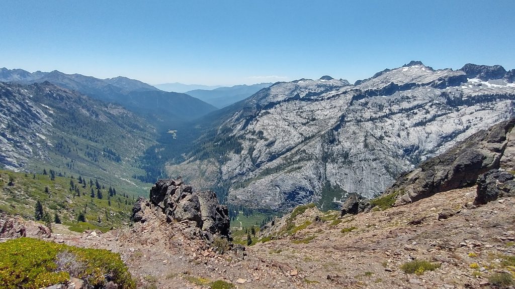
The challenge I faced getting down the ridge was enough. The trail was described as a “scramble” of around 90 short switchbacks. It was a 3000′ drop in less than 3 miles. Thank all the gods that I was going down. I was completely exposed to the beastly sun and my thermometer topped 97 degrees midway through. The terrain was extremely chossy and steep, requiring a lot of concentration and straining. Looking back up at the route from the valley floor, it was hard to imagine how a trail navigated such a slope…it looked more like a wall. The worst part was the lowest half mile, where I had to push through dense scrub oak. I couldn’t even see the trail, or my feet. Luckily I could just throw my weight into it, like a linebacker. I thought I might need to crawl on my hands and knees at one point, it was so bad.
Breaking free onto the Stuart Fork trail was such a relief. Not only was the trail immaculate, with obvious recent trail maintenance, it followed the river down, with access to cold refreshing water. I laid down in the creek the first chance I got, desperate to escape the near triple digit temperatures. The humidity had also risen as I dropped into the valley, feeling like a sauna. The hard part of the day was over, but so too were the amazing alpine views. It was just as well, as I followed the shaded trail through the trees, marveling at the miraculous forest.
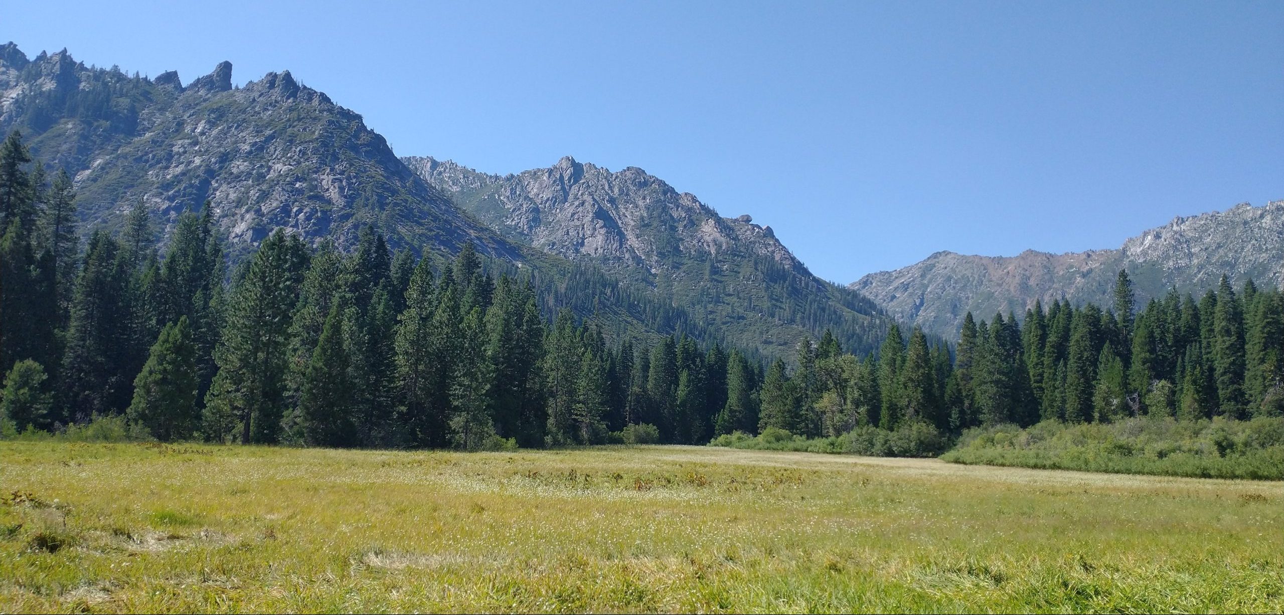
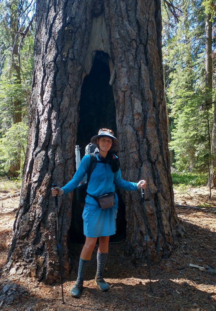
The first thing I noticed from the ridge was how intact the valley was, with not one burn area visible. Once in the thick of the forest, I was amazed at the diversity of the trees and just how large they were. It was the most beautiful forest I’d seen since leaving the redwoods. Here were some of my most treasured trees: giant Ponderosas. I posed for a picture in front of one. There were also a few gorgeous meadows along the way, providing variety and a few views. With great sadness, I thought how I might never be able to return to this valley. When the inevitable fire roared through, this magical scene might be gone. I couldn’t bear to see it again burnt, knowing what it had once been. It needed to live on safe in my memory.
I took many more dunking in the side streams as I traveled down valley. It was so ridiculously hot. I paused for awhile at one, letting my feet soak and pondering my options. I’d come to a big decision. Months before starting this trip, I took to heart Buck30’s considerations regarded the last 100 miles of the Bigfoot Trail. He noted that there was about 70 miles of dirt and paved road walking just to arrive at the last wilderness area in the Yolla Bollys. The route went about 25 miles through the wilderness, which was now mainly a large burn area with little to no trail. It also terminated at a dead-end road, some 50 miles from the nearest city. I had no idea how I’d get from the terminus, other than being really lucky with a hitch from such a remote area. Given all these factors, it just didn’t seem worth it, only to be able to say I hiked all of the Bigfoot Trail. Especially now, since I’d already missed 40 miles of the route in favor of staying on the PCT.
I’d pretty much decided against continuing past the Trinity Alps before beginning my journey, and now with heat, the answer was clear. I also couldn’t think of a better highlight to end on. In fact, the Stuart Fork valley was so grand and the trail so nice, I decided to follow it out to its terminus. The official Bigfoot route crossed the Stuart river to climb 3k’ up Boulder Creek (noted to be rough and overgrown), then back down Canyon Creek, followed by a 13 mile paved road walk to Junction City. My plan had been to take a bus from Junction City to Weaverville to Redding and up to Mt. Shasta…a lot of logistics to sort through and sure to take more than one day.
Looking at my maps, the Stuart Fork trail would spit me out close to HWY 3, which was a direct road back to the PCT at Scott mountain. My overriding goal of getting back to the Mt Shasta area was in order to reconnect with my friend Karaoke, who I met and hiked with on the PNT. She had just moved with her partner to Mt. Shasta (the town at the base of the namesake volcano) earlier in the year and invited me to visit if hiking by. If I could get back to the PCT, the trail would lead me directly to the I-5 interstate crossing near Castella, which is just south of Mt. Shasta. This new plan would also eat up a few more days before the weekend. Like most normal people, Karaoke had a job and I hated to drop in on her at the very beginning of the work week.
Clear as mud? No more climbing, bushwhacking, road walking, and bus schedule deciphering made perfect sense to me. I also didn’t have to cross the river, which in mid-August, would have been a cinch. It’s worth noting, for would-be BFT hikers, that the Stuart Fork is considered to be the most significant water crossing on the BFT. Incredibly, it’s not even listed as a waypoint on the Far Out app (shame on you product developers!), but it is prominently marked and noted on Michael Kauffmann’s BFT maps. Just be aware, as this could be a major roadblock if beginning the BFT in June.
Having made the decision to end the BFT about 120 miles short of the southern terminus (my second thru-hike not officially completed), I continued down the Stuart Fork trail another mile before setting up camp. I felt no regret or shame over my decision because it just made sense, given my circumstances and the conditions. My ultimate goal had been to connect these various trails, and in that, I’d succeeded thus far. In hindsight, I wouldn’t have even been able to finish the trail had I wanted to, since a fire started in the Yolla Bollys the very next day.
Twig, you are an amazing mountain hiking woman❣️
The memories you have, I can only imagine❣️????
I’m thinking you probably might have been going to PCT Trail Days, this weekend❣️
But there is no telling the adventures devised in your wonderful mountain heart❣️❤️????
God bless and keep you safe, as you go❣️????????????????
Big HUGS, gal❣️????
Hi Marlene, yes I did find a way to make it to trail days…it was wonderful how it all worked out. I’m working on the blog for that now.