Saturday, Aug 12th, 2023, 0630-1935
Bingham Lake to Big Flat Campground, via Packers Peak
23 miles, Gain 6100′, Loss 8050′, elevation 5000′
The wind picked up overnight and my tent was flapping a bit. Even so, it was a pretty peaceful evening. I woke several times and just stared at the stars. They were so brilliant. I was sad to leave the lake but I had a big day ahead. I was finally going to get back on the Bigfoot Trail, so no telling how hard a day it might be. My planned miles put me somewhere on top or just past Packers Peak, the Highpoint for the trail at 7830′. It promised to be a tough climb…2k’ in ascent and 3k’ descent on the backside.
The scramble back to the PCT from the lake only took 6 minutes going downhill. It probably took me 15 minutes the night before. I was only on the PCT for 2 miles before it broke east and I went west. Even though I’d been debating whether to keep pursuing the BFT or just continue on the PCT, I didn’t even hesitate at the junction. I guess I was just feeling optimistic and ready for more type 2 adventures. I immediately felt relief and satisfaction that I hadn’t given up on the route. I was also kind of happy to return to my almost guaranteed solo existence. It was nice to swim in lakes naked and for my footsteps be the only ones I saw. I didn’t even find such solitude on the Hayduke, but here in the remotest parts of NoCal, I certainly did. Just me and the burns.
The BFT was kind to me as I eased back into it. I left the Russian Wilderness and followed a clearly defined atv track for 3 miles down 2k’ to a valley. Where the PCT aimed to stay high on continuous ridges, the BFT went up and down constantly. As a reward, I arrived at Trail Creek campground with a really nice privy and trash cans. I double checked my phone to confirm that it was a Saturday, yet there wasn’t a single car at the campground that I could see. More easy miles followed along a dirt road to the Fish Lake trailhead. Again, no cars except for a truck parked at a pull-out near the creek. I didn’t see the people, who were probably fishing.
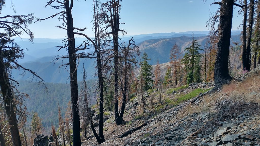
I entered the Trinity Alps Wilderness and was happy to find pretty decent trail along Fish Creek (these areas all have some of the most un-original names). It was overgrown in some places but easy to follow, with surprisingly few blowdowns. In fact, the whole day was relatively free of them, despite traveling through extensive burn areas. I didn’t mind the burns so much if I wasn’t also having to navigate fields of pick-up-sticks. They added a significant degree of danger, with their sharp skewer sticks ready to impale a hiker that might fall. Even at a point that the notes said the trail was hard to find, it was perfectly good and apparent. The GPS trackline was off in this spot, so I guess whoever was recording their track and taking notes had missed a switchback. I was heading in the opposite direction, southbound, so I was still on the trail from the creek, leading into the switchbacks to a ridge.
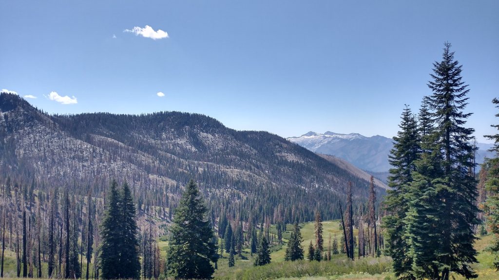
I gained all the elevation I had earlier lost but barely felt it on the pretty well-graded trail. It wound up through the granite and was PCT-quality in some spots, with built-in steps and rock retaining walls. It’s a real shame that so much time went into building this good trail, but now few were hiking or maintaining it. Actually, it did show signs of some maintenance within past years, so I had hope for it. I gained the ridge, with nice views to several valleys and lakes and the Caribou lakes area of the Trinity Alps. I spied these high and rugged mountains, with snow still lingering on the slopes, days ago when I was in the Marble Mountains. I didn’t yet know that I was heading for them and now I was so excited to reach them the next day.
I came to Rush Creek and Lake for lunch. I took my clothes off to rinse and soak, while I sat in the shade in just a top and underwear. I felt fairly confident no one would come by. I thought I might run into another BFT hiker when I first left Crescent City, but now I seriously doubted it. The break was so lovely. I felt very much at peace all day, even though I guess there were parts that should have concerned me. Being so isolated and later the trail so hard to follow, I could have gotten lost or had a dead tree fall on me. Instead, I felt very much at home. Ironically, I was listening to a Radiolab podcast about our performance when we are alone versus with others. It was about a woman who was disqualified from setting the fastest known time for bicycling the Arizona Trail, just because her wife met her at many of the road intersections. She didn’t give her food or water, claiming she was only there to document the race with pictures. The race organizers decided that just the emotional support was enough to give her an unfair advantage. The science supported this but I had to wonder. I felt like I’d been thriving being alone this whole hike. I loved making my own decisions, setting my own schedule, and doing the things I felt comfortable with.
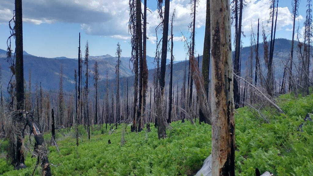
One thing I knew I was good at was following scant trail. It disappeared past the lake, so I just found my own way up to a ridge and down the other side. The burns became pretty severe in this area, with every footstep collapsing into the crumbly soil. It slowed my progress, kind of like walking through snow, but I wasn’t in a hurry. I’d made good miles earlier. At a saddle before the climb, I had the option of taking an alternate down to the valley. Notes warned of it being a messy bushwhack, but so too was continuing to the top of Packers Peak. I saw not a trace of an old road or a trail at the intersection. I continued up, determined to reach the Highpoint of the BFT.
The going was actually pretty easy and straightforward…just follow the ridge. I did find trail here and there, but the burn had cleared the landscape pretty completely, so I just made my own way for the most part. Past the midway point of the climb was an icon for water. I didn’t need any but investigated a couple of patches of green anyway. I found a spring bubbling from the charred earth, yet another miracle of nature. I spooked a small buck from this special place, the only large animal I’d seen in this desolate area. He too had been attracted to the sweetwater. Then I did something I never do: I dipped my cup in the spring and drank directly from it. I always filter my water, but I was so suddenly inspired to take communion from this source, unadulterated. I didn’t even think about, I just took in the cold delicious water. It’s never tasted so good and probably never will again. What a moment… it’s hard to describe, it was so magical.
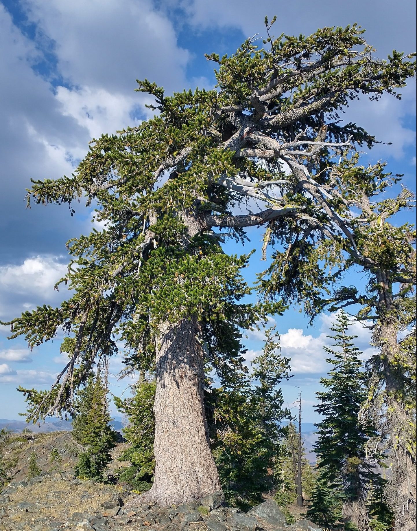
I found the trail shortly after this, in-tact the rest of the way up. It’s a good thing too, as the slope got very steep, with a few cliffs to navigate around. Though it was washed out, crumbling into the abyss in a few places, some trail is always better than no trail in these kind of spots. It expertly switchbacked the slope, finally arriving at the top. What views! The climb was so worth it, especially coming from the north, where the grade was much more gradual. I would have hated to climb the south side. I spent awhile up there, taking it all in. As promised in the notes, I found a lovely stand of foxtail pine trees, so gnarled from the elements. These trees were such amazing survivors, thus far making it through the worst of the burns, droughts, snow, and wind. How? I couldn’t even imagine.
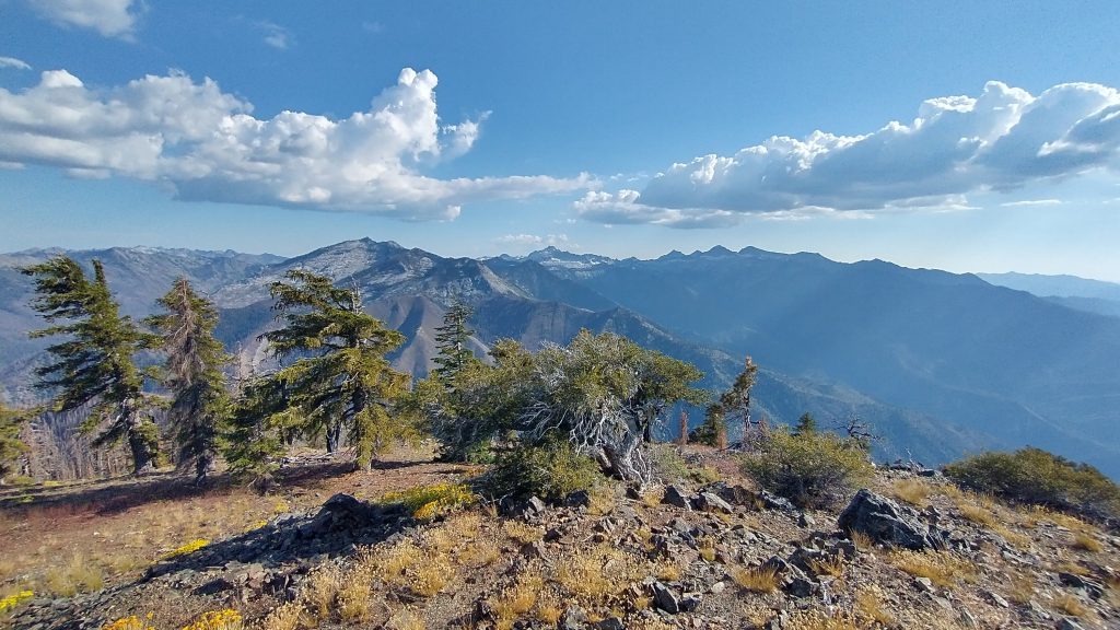
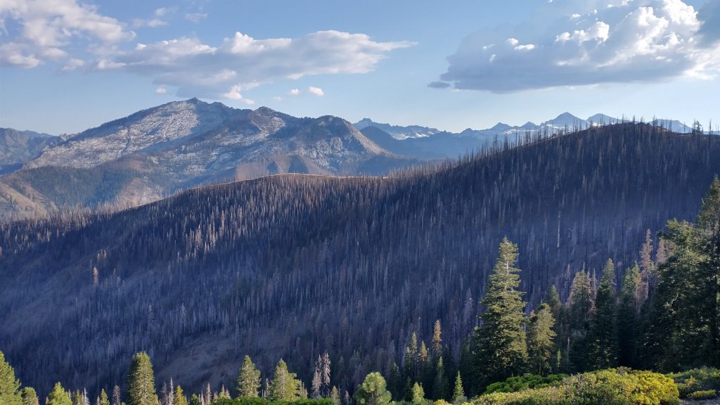
I found the USGS marker and remains of the old fire tower. I felt like the first person to visit this place in a long time. For a moment, I contemplated camping on top. I had enough water and it would have been the perfect place to watch the meteor shower. I felt like an idiot to pass up the opportunity, but for reasons you’ll see in future posts, heading down this afternoon turned out to possibly be a life-saving call, though I had no inkling of it at the time. I began the descent of 3000′ in 3 miles. The faint trail wound down the ridge through the foxtail, then traversed the steep slopes…and I mean steep! The slippery gravel and sketchy drops reminded me of the Nankoweap trail in the Grand Canyon. A slide could have been bad, so I did my best to stay upright. The trail was slanty and barely visible, but still better than nothing. I wondered how much longer people could manage to walk it? Surely not many more years. I was so grateful to let gravity do most of the work…but not too much too fast.
I made it down to the valley floor after many switchbacks and a lot of concentration. My legs were very shaky, so I was relieved to let go of all the strain on an easy road walk towards a campground. I walked past a resort, noted to take packages and have some snack options, but it was too late in the day to investigate. I arrived at the popular Caribou lakes trailhead, noting the many cars parked on a Saturday night. There must have been 20 or more people up at the lakes, but not a single party at the campground. Aside from a few trailers in a corner, I had it all to myself. I took an amazing dip in the South Fork Salmon River, washing away all the sweat and soot of the day. It was the perfect finish to a hard but incredibly rewarding day. I knew I would sleep well, meteor shower be dammed. I needed to replenish my body.