Wednesday, July 5th, 2023, 0615-2000
Columbia River, Fort Stevens State Park (Northern Terminus of the Oregon Coast Trail) to Sunset Beach
9 miles, Gain 30′, Loss 30′, elevation 30′
This was one of the best first trail days I’ve ever had. That’s because for most of the day, I got to be a tourist as we enjoyed the sights around Astoria and celebrated a birthday. But first I had to recover from a night of restless sleep (mostly of my own doing) and a subsequent migraine. Coffee and a breakfast with some delicious mango snapped me out of it (along with my prescription Sumatriptan). I know it worried my hosts that I was feeling bad, but I dealt with migraines all the time, so was used to it. I just had to wait for the medicine to kick in…and it did.
Initially I was considering a very long day to start. I wanted to begin early in the morning and hike 25 miles to the backpacker camp on Tillamook Head. In retrospect, this would have been a terrible plan, with way too many miles for a first day. So I’m actually glad I woke feeling under the weather because I had to concede that a shorter day was in the cards. This also meant that I got to spend more quality time with my hosts, though I also felt bad monopolizing their time. Whatever we ended up doing, I wanted it to be something everyone enjoyed. We’d been discussing all the fun tourist things in Astoria and Shelly and Ray seemed excited about playing tour guides, even of it was all stuff they’d seen before.
First we visited the Columbia River Maritime Museum, which was right up my alley given my Coast Guard, NOAA Corps and general nautical background. I hope I didn’t drive Ray and Shelly crazy with all my sea stories from the past! The museum conjured up a lot of memories along with some useless nautical information. I can be like one of those old crusty sailor guys reliving my glory days at sea. Then we had a wonderful lunch at the Bridgewater Bistro, watching traffic flow over and under the incredible bridge spanning the gigantic Columbia River. I’d just paddled under the Seven Mile bridge in the Fl keys 2 weeks prior, but this bridge seemed even bigger. It was certainly higher.


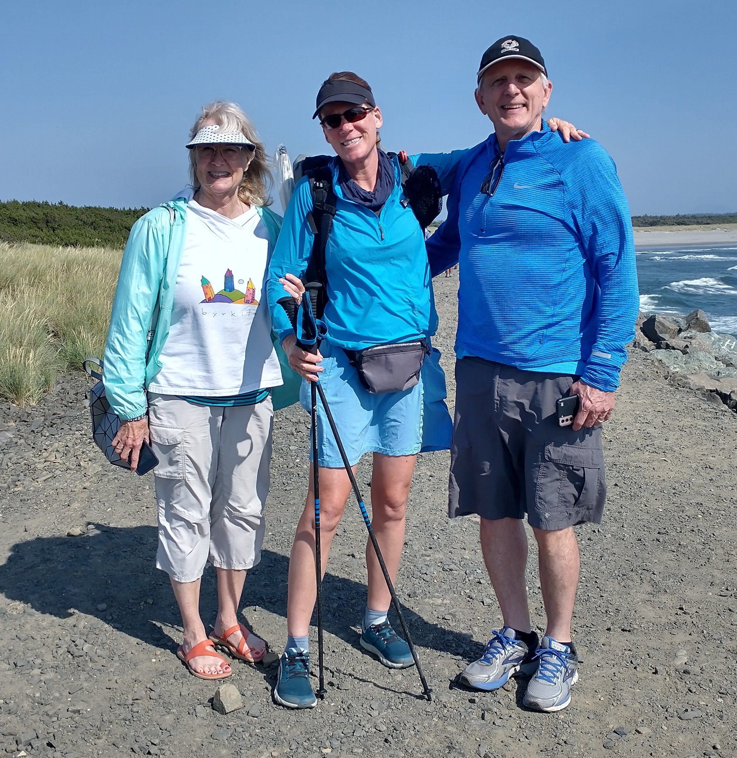
Lastly, we visited the Astoria Column, a memorial tower on the highest nearby hill with incredible views. It’s apparently tradition to launch wooden gliders off the top…after climbing the seemingly endless spiral staircase. Ray bought 5 for us, eager to show me the strategies of attaining the longest run… supposedly a glider made it miles off the top of the hill and down to the river once. We barely made it past the parking lot but still, after our first flight, I was hooked…I felt like a kid again! The town reminded me a lot of Port Angeles and I so enjoyed spending quality time with my hosts. But finally it was time to hit the trail, so we drove back across the bay to the state park and start point.
Almost exactly 1 year before, I crossed the Northport bridge over the Columbia on the Pacific Northwest Trail, near the Canadian border. This day, I resumed my incredible Pacific Northwest journey from the mouth of the Columbia. I was sad to say goodbye to Shelly and Ray, but it was so nice to have them there to see me off. It’s a great feeling to wave bon voyage to someone who cares about you, as you set off on such a journey. I had the same lighthearted and joyous feelings that I felt at the start of Te Araroa…my other beautiful beach start. The sun was shining, waves crashing, gulls laughing, and everyone on the beach seemed happy. It’s just a very happy place …when conditions are calm.
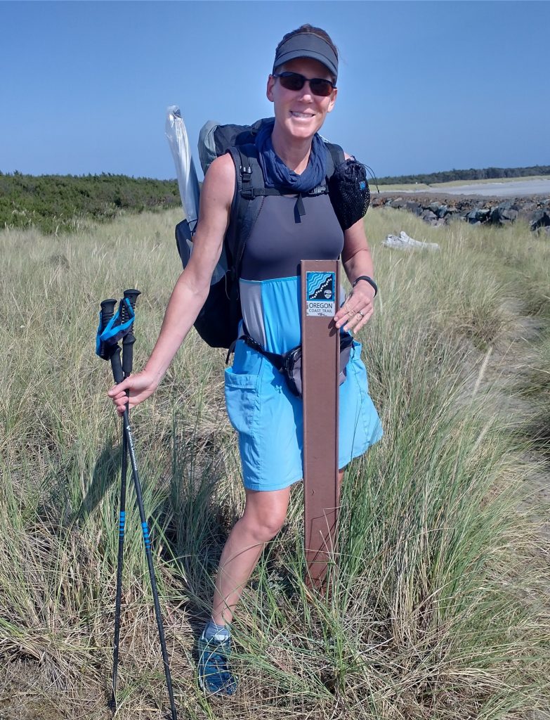
I couldn’t find much evidence of the OCT at the terminus, other than a sticker on the kiosk and a carsonite marker in the dunes. These would have to do for my start pictures. Ray noted that my hiking outfit matched the colors of the OCT signage…I hadn’t been trying nor did I intend to be completely decked out in blue, it just kind of happened.


Even though I didn’t begin until 5 pm, the flat and hard sand made it easy to knock out 9 miles off the bat. I could only see about half a mile in each direction because of the haze, so the observation tower and jetty disappeared quickly behind me. Then it was just a conveyor belt of sand. Figures would appear from the haze, setting a goal for my next arrival point. Slowly 2 backpackers emerged as I began to overtake them. It took me more than half an hour to catch up and they were as I suspected, 2 OCT hikers, Reed and Jamie. It was their first long hike. Previously they had been planning to do the Tahoe Rim Trail, but the creeks were running too high from all the snow melt, so they changed plans. Good call!
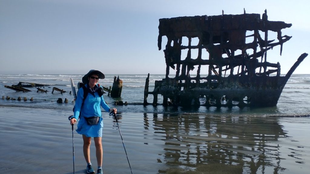
Four miles into the hike, we all stopped to admire the wreck of the Peter Iredale. It was an 1890 steel-plated, iron-framed British vessel that ran aground in 1906. It’s actually quite remarkable that anything of this vessel remained after over 100 years…a testament to its very sturdy build. It’s also a reminder of just how dangerous this coast used to be. The stretch all the way to Vancouver is known as the Graveyard of the Pacific. I served as Navigator on my NOAA Ship at the time when we sailed from Honolulu to Seattle, so I knew first hand how difficult conditions could be. Thankfully that trip went as planned and we didn’t end up on the beach. Ship design and navigational aids had come a long ways since the Iredale days.


I bid farewell to the couple, as they were stopping at the state park hiker biker campground and I wanted to walk a few more miles. The crux of much of the OCT was in finding campsites. From here all the way to the towns of Gearhart and Seaside, there weren’t too many options. The most common complaint about the OCT is the lack of legal beach camping. It’s not allowed in city limits, state parks, snowy plover areas and a myriad of other circumstances. This was not a concern of mine because I actually shunned camping directly on the beach. Not only had I gotten my fill of it from kayak camping in Florida, battling with the wind, sand and condensation were big detractors for me. So I had my sights on the nearby line of coastal pines… satellite imagery helped with finding this. But first I had to go at least 3 more miles to get past a military base, Camp Rilea… definitely didn’t want to stealth camp there! My feet were really hurting during this last stretch and fatigue from lack of sleep was setting in. Plus, the beach became less enjoyable once I hit the area where vehicles were allowed to drive…a pretty common thing along the Oregon beaches, it turns out. I hate sharing hiking space with motors, I really do. It’s noisy and dangerous, just a big BOO! I found it interesting that parts of the first beach hike in New Zealand also allowed vehicles…so far both trails had a lot in common.
I followed the first path I found into the dunes after Camp Rilea. It was a private path leading to a house, but I veered off as soon as I came to a no trespassing sign. I reached a line of low pines and found a perfect clearing under them. It looked like a place where deer bed down and was just right for me. I was ecstatic to be so hidden and away from the noise of vehicles, firecrackers and other nuisances. I could just hear the surf over the dunes, the perfect white noise. I quickly set up and had dinner, my routines instantly coming back to me. I was so excited to sleep…I have never slept as good as I do in my tent, in a safe and hidden place. Bliss.
PS… I posted a lot more of my pictures on Instagram @twigadventures