(Scroll to the bottom for a listing of links to all my posts, see this link for the rest of my 2025 PCT hike)

From the Hike Invention website: “The Desert Winter Thru-Hike (WTH!) is an adventurous 800-mile hiking route highlighting 20 Wilderness Areas, 7 National Parks and Monuments, and remote protected lands of the Sonoran, Colorado, and Mojave deserts. Featuring mainly low to mid elevation (2000′) desert valleys and mountain ranges occurring at lower latitudes of the American Southwest (the highest point is Harquahala Mountain (5,691ft/1735m), the Desert WTH offers a true winter season thru-hiking option for very experienced walkers looking to extend the US hiking season into the December – February timeframe. And yet despite the aridity and remoteness of this warmer region, the route has been carefully crafted to greatly reduce or eliminate the need for caching water in advance, while also providing easy access at its termini both to begin and end the long hike.
The Desert Winter Thru-Hike connects the Arizona National Scenic Trail on the east with the Pacific Crest Trail to the west, along the way touring such diverse treasures as Saguaro National Park, Ironwood Forest National Monument, Sonoran Desert National Monument, Mojave National Preserve, and Joshua Tree National Park, all while showcasing the hallmark plants, animals, and distinctive landscapes endemic to each.”
The Desert Winter Thru Hike was my 3rd Brett Tucker Route “BTR”. To be eligible to receive the mapset and data for this hike, I needed to have proven to be responsible and successful on another BTR of at least 500 miles. This meant contributing to the knowledge base surrounding the hike (water reports), being a good steward of the land while traversing fragile desert ecosystems, and demonstrating sufficient skills in route-finding, navigation, and water management.
Previously, I’d hiked both the GET and MRT. Further, I’d amassed quite a bit of experience in desert travel since 2018. This was my 4th long hike across Arizona (AZT, GET, MRT, HDT) and 3rd across a long swath of California (PCT, PCBCRT). In total, I’d already walked over 1,600 miles through AZ (entire length plus half the width x2) and 2,900 miles through CA. Perhaps most significantly, this was my last segment in completing the nearly 7,000 mile Great Western Loop, as conceived and named by Andrew Skurka, Ryan Jordan, and Demetri Coupounas in 2006.
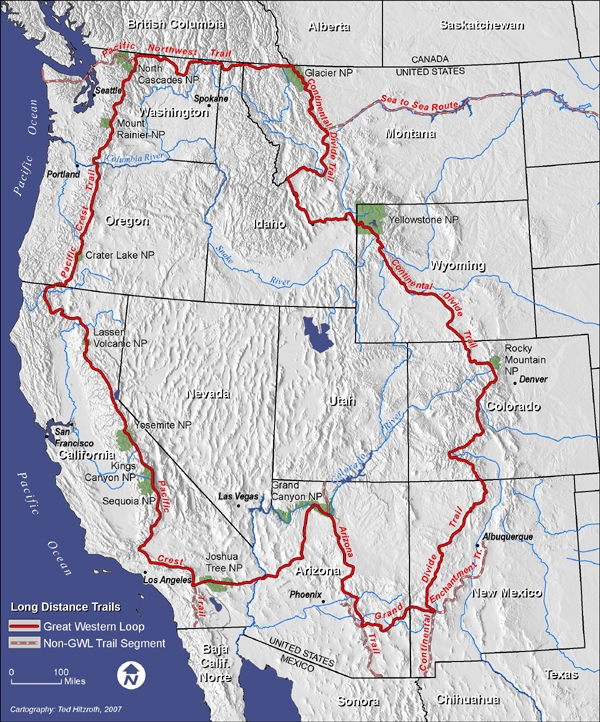
Only a handful have completed the GWL as a continuous thru-hike, as it’s truly one of the most ambitions and arduous routes ever conceived. I met one of these hikers, Chezwick, while hiking the PNT. Seeing him in person and noting just how haggard he looked (though he was ultimately successfully, yay Chezwick!), I concluded that I would never attempt the GWL as a continuous thru. I just couldn’t imagine putting my body through such punishment. After all, Chezwick broke his foot after 4,500 miles in his first attempt and needed 2 knee surgeries after his second attempt! No thank you.
But what about section hiking the GWL? The simple and pertinent matter going into this hike was that I’d almost already done it (having hiked the PCT, PNT, CDT, GET, and AZT as thru-hikes). Thanks to Brett’s unending commitment to inventing new routes, a viable, enjoyable, and information-rich route now exists between the AZT and PCT. He even made it easy by mapping connector routes at either end of the official DWTH.
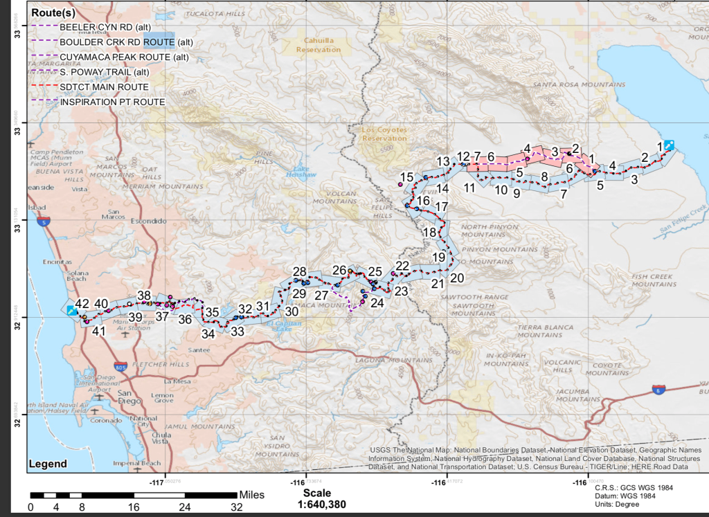
In making it to the PCT, I also planned to do a bonus hike to connect from the desert to the coast. Although my footpath wasn’t initially continuous (later achieved during a PCT section hike), I hiked all of an established route called the San Diego Trans County Trail (SDTCT), from the Salton Sea to the pacific coast, ending in Torrey Pines State Park. It added over 155 miles to my journey…but what’s another couple hundred miles? Saying I walked from Tucson to San Diego sounded cool and I likened it to my PNT hike, where I finished hiking along the Pacific Ocean. As such, this hike shared a nice symmetry to the PNT, just at opposite borders of the country.
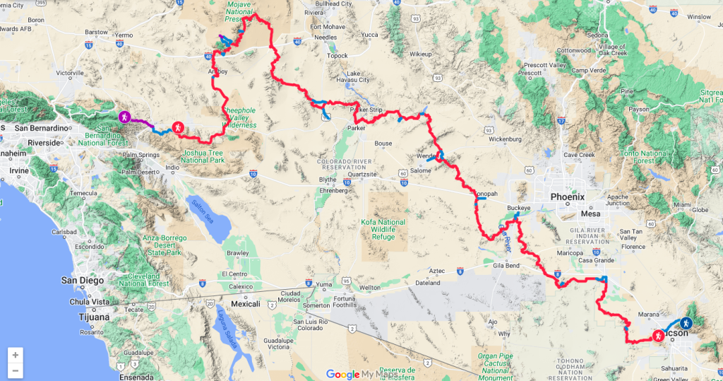
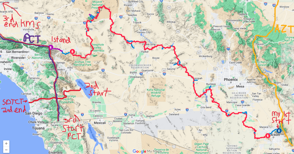
To connect my footsteps between the DWTH end and the SDTCT, I hiked the entire desert section of the PCT, from the Mexico/US Border to Kennedy Meadows South, about 700 additional miles. As a result, my overall DWTH was about 1600 miles long. I consequently had 3 different start and end points along the way. Confusing? Maybe the map below can help clear things up.
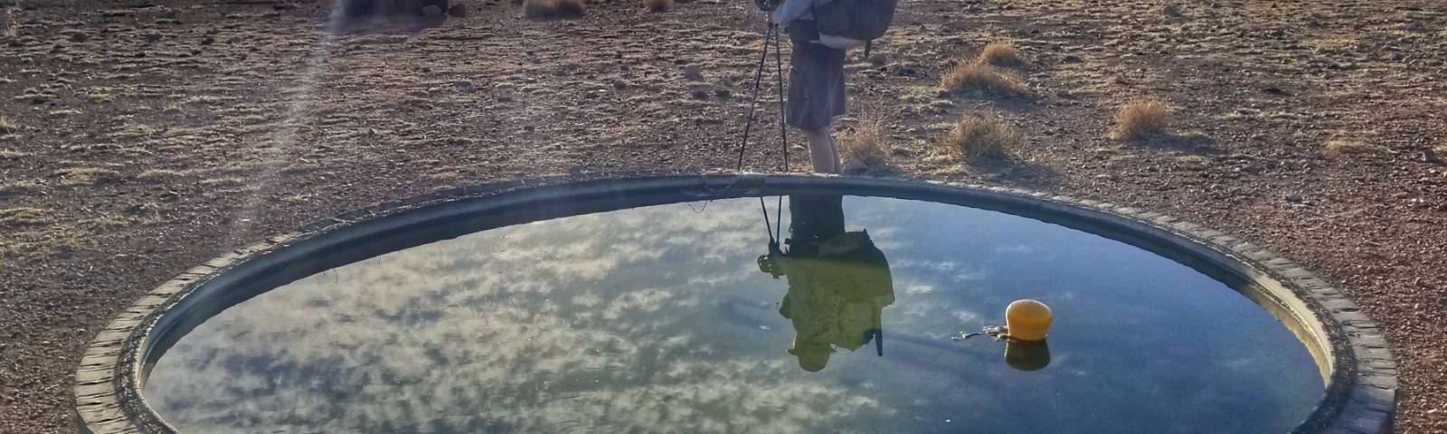
The major challenge of my journey was a severe drought throughout the region (as highlighted by the devastating LA fires in January 2025). I’d dealt with both droughts and floods in the desert before, but these conditions were pretty extreme and dire. I suffered through 30-50 mile water carries and mandatory caches. Initially, I did not cache water or food through AZ, as there seemed to be enough water in the cow troughs and guzzlers. After a few of these were reported as foul by hikers ahead of me, I was able to have a few caches set by Trail Angels at the last minute. The small quail guzzlers in southern CA, which the route mostly relied on, were severely depleted or dry. So once I got to Parker, the roughly halfway point on the border of AZ and CA, I set water and food caches through all of the Mojave section. My friend Alan greatly assisted me with this task.
There were many other logistics associated with this hike, given the sparse resupply options, which I went into detail about in my daily blogs. But overall, I think my half & half strategy of caching was a good one. In this way, I left myself an out halfway through the hike (with no caches to have to retrieve if I didn’t make it all the way). I also ensured that no caches were out for more than 2.5 weeks, improving the chances of finding them intact. In the past, other hikers have been able to do the entire route without a single cache. My experience provides a good example of doing the route in an extremely dry year, which is likely to become the norm as climate change worsens. I hope future hikers will have better luck than me, but the route is still doable even without many of the built-in water sources.
Here are few other DWTH blogs folks can check out for more information:
LarryBoy’s Summary: https://www.lbhikes.com/2024/02/desert-winter-thru-hike-advice-to.html?m=1
Buck30’s Journal: https://www.postholer.com/journal/Other-Trail/2022/buck30/2022-12-13/WTH-Summary-and-Planning-Notes/67352
Recon’s 2023 Journal: https://ramblinrecon.com/hikes/desert-winter-thru-hike-2023/
Nate Ventura’s Journal (current season hiker): https://longwalksanddirtysocks.wordpress.com
NOTE: The maps, water, data, etc on this route are not public. The route traverses sensitive areas, can potentially be dangerous, and is still in its infancy. For the foreseeable future, Brett is only sharing his resources with people who have successfully hiked one or more of his other routes over 400 miles. Please don’t inquire with me about sharing any maps/data/files. I’d highly recommend the MRT to anyone looking to try their first Brett-Tucker-Route “BTR”.
Here are all my daily blogs and other posts related to the DWTH, SDTCT, and my bonus desert section of the PCT:
Introducing the Desert Winter Thru Hike
DWTH Pre-Game show
DWTH Day 1: Rainmaker
DWTH Day 2: The Highpoint of the Trail
DWTH Day 3: Saguaro National Park
DWTH Day 4: Cow Troughs and Javelina
DWTH Day 5: Waterman Peak
DWTH Day 6: Hot and Dry
DWTH Day 7: Arizona City
DWTH Day 8: Water Water Everywhere..
DWTH Day 9: A Big Carry
DWTH Day 10: Keep Calm and Carrot On
DWTH Day 11: North Maricopa Mountains Wilderness
DWTH Day 12: Buckeye
DWTH Day 13: Buckeye Hills
DWTH Day 14: Woolsey and Signal Peak
DWTH Day 15: Saddle Mountain
DWTH Day 16: Big Horn Mountains
DWTH Day 17: Harquahala, Be My Valentine
DWTH Day 18: Salome
DWTH Day 19: Harcuvar Mountains
DWTH Day 20: Lake Alamo
DWTH Day 21: Bill Williams River
DWTH Day 22: Burros will make America Great Again
DWTH Day 23: Tiabombs For Those That Make It Across the Desert
DWTH Day 24: Parker
DWTH: 3 Day Midway Caching Hiatus
DWTH Day 25: Whipple Wash
DWTH Day 26: Whipple Mountains
DWTH Day 27: The Turtle Mountains…Wow!
DWTH Day 28: Old Woman Mountains
DWTH Day 29: Fenner
DWTH Day 30: Into the Great Wide Open
DWTH Day 31: Hole-in-the-Wall
DWTH Day 32: Hill Top House
DWTH Day 33: Monzogranite, Budweiser & Rain
DWTH Day 34: Rescue on the Way to Amboy
DWTH Day 35: Zombies, Roy’s, & Lava
DWTH Day 36: Sheep Hole Mountains
DWTH Day 37: Pinto Mountains
DWTH Day 38: Joshua Tree National Park!!!
DWTH Day 39: The Homestretch
DWTH Day 40: Desert Hot Springs Layover
DWTH Day 41: Whitewater Preserve & the PCT
DWTH SDTCT Day 1: The Salton Sea
DWTH SDTCT Day 2: Borrego Springs
DWTH SDTCT Day 3 & 4: Stagecoach & Unexpected Zero with Friends
DWTH SDTCT Day 5: Crossing the PCT
DWTH SDTCT Day 6: Cresting the Crest, Then Big Descent
DWTH SDTCT Day 7: El Cajon & Trans-passing Like A Champ..it’s not what you’re thinking
DWTH SDTCT Day 8: Urban Thru-hiking
DWTH SDTCT Day 9: The Finish Line at Torrey Pines
DWTH PCT Days 1-13: Mexico Border/Campo to Whitewater Preserve
DWTH PCT Days 14-25: Whitewater Preserve to Acton
DWTH PCT Days 26-39: Acton to Kennedy Meadows South
DWTH, SDTCT & PCT Desert Section Summary & Stats