Tuesday, July 24th, 2023, 0630-1630
Crook Point to Harris Beach State Park
20 miles, Gain 3000′, Loss 2800′, elevation 150′
It was a good call to stay where I did. Not only was it a fantastic site but it set me up well for a 3 mile walk on HWY 101 first thing. There’s usually no better time than the early morning. Even still, there were a surprising number of commercial trucks going by…but it makes sense that professional drivers enjoy the light traffic in the mornings, as well. The highway at least had a pretty wide shoulder and also some passing lanes at regular intervals. Oddly, only a few vehicles gave me the courtesy of moving over into the left lane as they passed. It’s such an easy thing to do, so either people weren’t aware or they didn’t care, probably both. One truck actually crossed the shoulder paint, taking an uncomfortably close swipe at me. Such actions always feel intentionally evil, but I know how often people accidentally drift toward the direction they’re looking or are just distracted. Either way, the result would be dire for me. I finished the road walk kind of feeling like a piece of meat…drivers slowed down or moved over more for deer, it seemed like.
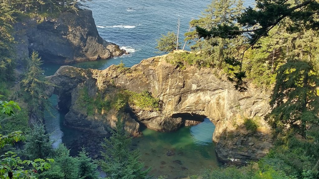
I entered the Boardman State Scenic Corridor, which was one of the most beautiful stretches of coastline, with heaps of sea stacks, arches, natural bridges, coves, and pocket beaches. The founder, Sam Boardman, wished for it to become a National Park. It was also the inspiration for the Oregon Coast Trail, with a series of almost completely connected trails running throughout the corridor. It was a feat to build these trails because the geography was so rugged and prone to landslides. That was apparently the fate of the first trail I spotted. My old GPS trackline led me to it and there was even an OCT marker, but the trail came to an abrupt halt only 5 yards in. I backtracked to the highway, where I walked for almost another mile. Finally, just before Arch Rock viewpoint, I picked up the trail.


There was a sign at the beginning that read “trail open but not maintained.” The funny thing is that there was recent maintenance and most sections were in decent shape. But trail sleuthing became my pastime for much of the day. Several factors led to this: The trail was not completely continuous, as there were places that it followed 101 for a bit. Some of the trailheads along the highway were not marked, nor were there markers at a lot of critical junctions. A spider web of social trails broke off to go down to a beach, a viewpoint, or back to the highway. And lastly, my GPS trackline was worthless, almost always off to a significant degree. I got it for free from an app called Hiiker, so I can’t complain too much.
The guidebook map and turn-by-turn descriptions were the most helpful, but even Bonnie couldn’t fit in every detail for this convoluted area. I fear that many hikers just end up walking more sections of the highway out of confusion and frustration. I missed one or 2 bits of trail myself, so if I found it difficult after all the extreme route-finding I’d done, I can only imagine what it’s like for someone on their first long distance hike. What the trail really needed were some blazes…there were plenty of trees after all. This would help distinguish the main trail from all the side and social trails. It would also hopefully cut down on the formation of so many social trails. It was odd that the state promoted this area so much and had an incredible resource in trails that already existed and were being maintained, but then fell short in the basic task of mapping and signing the trails.
Oh, and in addition to all the things I just outlined, the trail did some crazy ups and downs all day. The whole corridor consisted of bluffs that were hundreds of feet high, so with that convoluted topography, so went the trail. I didn’t mind it much in the beginning, but it did wear on me by the end of the day. The section was only about 12 miles long, but these were hard won miles. However, trying to follow along the trail was so worth it, as it led to all the amazing views and several incredible beaches. I later talked to both cyclists and drivers that had very little idea as to all the special places that existed there. They might have visited one or 2 viewpoints plus a beach, but virtually saw nothing of the hidden coast, beyond the highway. Some didn’t even know what I was talking about when I mentioned the scenic corridor. They’d blasted right past it. The only way to get a feel for it was to walk the rugged and convoluted trail.
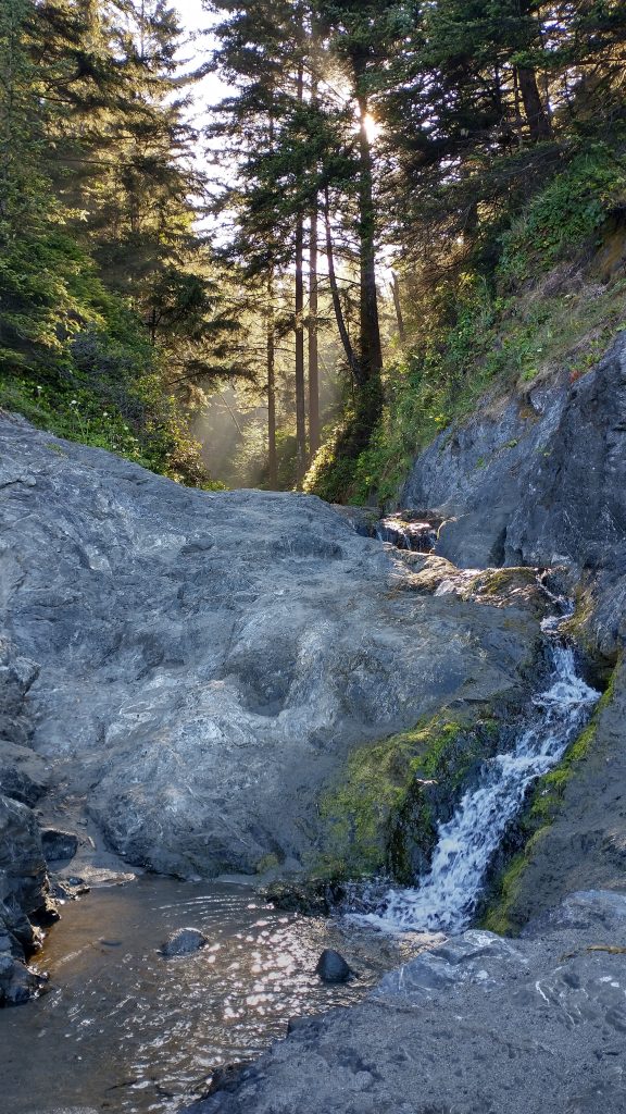
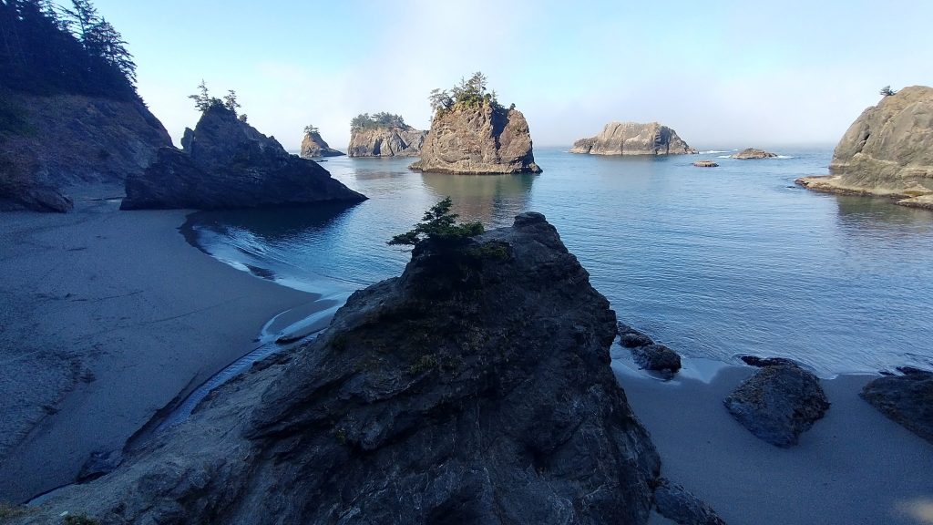
It would be too much to describe in detail my morning and afternoon of trail sleuthing. But I’ll list some highlights: Secret Beach…which literally took my breath away. It was easy to reach from the highway, so not so secret, but I was there early and had it all to myself. There were several waterfalls and some amazing rocks. China beach was also nice, where I met a NOBO hiker, Nick, and his dog. Nick had the worst case of poison oak rash I’ve ever seen. It was all over his legs and feet. He said he got it from wearing sandals but watching his dog roll around at his feet made me wonder about that. I stopped to chat for awhile, since I didn’t often get a chance to talk to other hikers.
Inevitably, I took a wrong turn at one point and ended up back on the highway. I complain about finding all sorts of trash along the side of the road except for money, but this day I found $2! With that, I could afford to buy…well, not much these days. I’d put it towards my laundry fund…it had been 10 days and counting since I last washed all my clothes in a machine. Sink laundry had gotten me by but still. After China beach was a lot more crazy trail and then Whaleshead beach. The south exit from this beach was washed out by a landslide and the trail severely eroded and unmaintained even beyond the slide. I’d read that other hikers had turned around, it was so bad, but I pressed on and was able to make it through. I climbed for a long time to reach Sand Point, the highest headland in this stretch at over 400′. It had a great view and memorial to Samuel Boardman. Earlier in the day, I also found a tiny memorial to Samuel Dicken, the founder of the OCT. The guidebook made no note of it, yet it seemed like an important landmark.
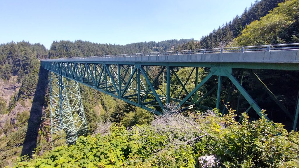
Lastly, somewhere in between, I crossed the Thomas Creek Bridge, spanning a gap 345′ high. A sign read that jumping & diving was prohibited…no kidding, because it would mean certain death! How is that not prohibitive enough? I guess it was probably aimed at base jumpers, who no doubt had been tempted by it. There was almost no shoulder on this bridge, so it was by far the scariest crossing yet. I jogged across to make it go by faster, only daring to stop to peak over the side once. Yikes!
The last bit was a few more miles of road walking to the state park. I didn’t have another dinner left but had enough snacks to get me by. I really wanted a hot shower, plus I didn’t want to end up in another situation trying to stealth camp near the town of Brookings. So a stay at the hiker biker site was a good call. This state park at least had the site off to the side in a quiet area, not surrounded by RVs. I met some nice bicyclists and a Dutch couple that had just gotten off the PCT due to injuries. This would be my last night in Oregon, so it seemed fitting to stay at the last state park.
Your comment about doing great work on trails but neglecting the basics rings true about trying to find one’s way on some of the Denver bike trails. Rolling on a very nice path when it suddenly ends. Yes, it continues at some other point, but there is no indication of how to get to it. How about painting a msg on the path? The locals or at least the ones I encountered were I clueless. Arggh