Both these trails were relatively short, hence this short(er) post.
Some thoughts and findings from the BMT: First, thanks to all the volunteers that make this trail happen! Yes there are blowdowns and overgrowth, because all that stuff happens daily, especially in the summer! Trail maintenance is a constant thing and I saw how dedicated the volunteers were in trying to keep up with it. Thank you!
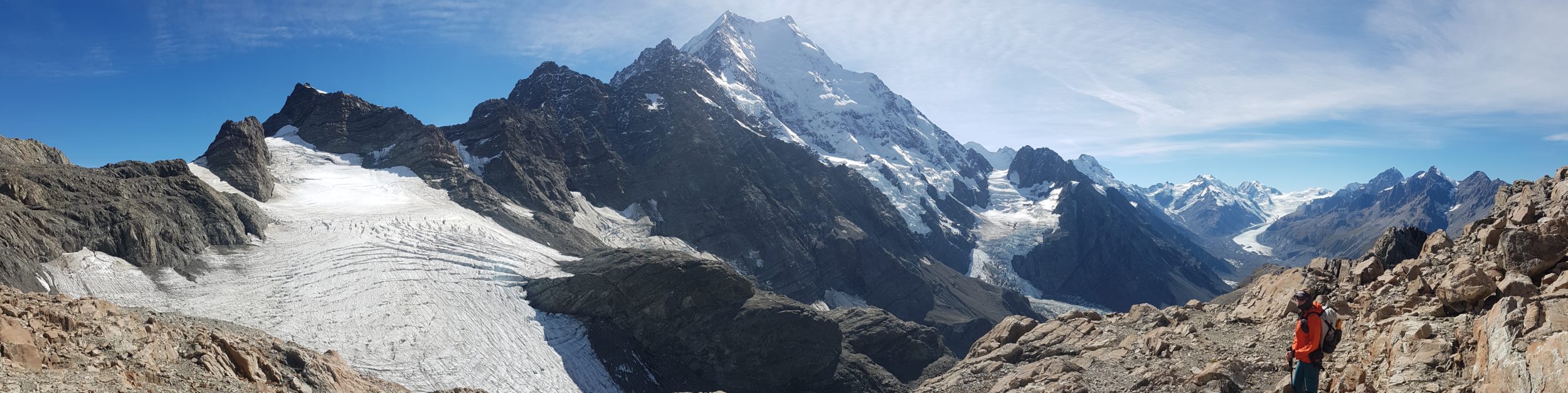
Anyone looking for solitude and that remote wilderness feel will find it on the BMT. I saw only 7 BMT thru and section hikers in 2 weeks.
Some of the climbs and descents were brutal but there were also a lot of cruisy sections, especially parts following old road beds along the ridges and river valleys.
I’d say April or October would be the most ideal months for a thru-hike. A May 1st start aligned with my plans to go to Trail Days afterwards, but I’d have preferred a little less foliage and a lot less undergrowth…poison ivy.
Bugs weren’t bad. I got 3 ticks in the Tapoco to Fontana section but there were hardly any mosquitoes anywhere in early May. The gnats could be pretty annoying in places, though.
The distances in Far Out seemed to be way off in some stretches, especially north of Blue Ridge.
It can rain a lot and be pretty overgrown, with lots of poison ivy. I didn’t wear long pants because I’m not very allergic to it, but others may want better protection.
Many rocks and wooden stairs and bridges were very slippery from all the rain and humidity. I slipped and went down hard on the stairs going down to the Ocoee River. My trekking poles saved me on numerous occasions. Just be careful!
Resupplies at Blue Ridge (Expedition Bigfoot Museum), Reliance Fly and Tackle, and Fontana Village worked well for me. There were lovely and friendly folks at all those places. Thanks so much! Great hiker box in Reliance too.
Benton MacKaye Trail Stats, including Day 0 on the Springer Mountain Approach Trail
Dates: April 30-May 14th
Duration: 15 days
Distance hiked: 299 miles, including the approach trail (this also this doesn’t include the 16 miles of official trail I skipped due to the storm).
Average Daily Distance (w/o zeros): 21.6 miles
Longest day: 32.5 miles, Day 12
Shortest day: 10 miles, Day 0
Days hiking 15 miles or less: 4
Days hiking 15-25 miles: 4
Days hiking 25-35 miles: 6
Zeros/Neros: sort of…1 unexpected weather day
Biggest elevation gain / loss in one day: Gain: 7550′, Loss: 4250′ Day 12
Favorite Day(s): the first 4
Nights tenting on or near trail: 11
Nights in a shelter: 2
Nights in a hostel: 1
Nights camping alone: 8
Nights camping with only 2 or 3 others: 4
Days seeing no other hikers: 4
Towns/resupply points visited, in order: Amicalola Falls Visitors Center, Iron Bridge Cafe, Expedition Bigfoot (Blue Ridge), Reliance Fly and Tackle, Robbinsville NC (unplanned stop), Fontana Village, Standing Bear Hostel.
Resupply parcels mailed/left in towns: 3 (Expedition Bigfoot=dropped off by Mando on the way to shuttle my car, Reliance Fly & Tackle=mailed, Fontana Village=dropped off by Loraine.)
Longest I went without a hot shower: 9.5, but I bathed in a creek or river almost everyday, so I could’ve gone the whole trip without one, easily!
Precipitation on the trail: 8 days of 15. One night of very severe storms, 5 inches of rain, and tornadoes. Water was everywhere!
Campfires: 1 on Newton bald, made by others
Injuries: I fell going down some wood stairs into the Ocoee River gorge, bruising my elbow pretty badly. I also started feeling some mild but chronic pain in my right ankle and heel, related to ongoing issues with my big toe joint and knee.
Animals sighted/signs/noises (both trails): I saw 1 black bear on the BMT and then 4 in one night on the FHT. The reactions of the bears were consistent with the use of each trail. The BMT bear acted like it had never seen humans much before and bolted away in fear. The FHT bears were extremely habituated, consistent with the large number of people I saw hiking, trash in the campsites, and proximity to houses and roads. I also heard or saw: frogs, salamanders, red efts, toads, red headed skinks, turkeys, whippoorwills, barred owls, warblers, thrushes, vireos, robins, towhees, phoebees, woodpeckers, deer, squirrels, chipmunks, invasive hogs, horses/riders, and one lost hound dog.
Hitches, Trail Magic and Trail Angels (both trails): My friend Eve in Gainesville FL, who I stayed with a few days before reaching GA. Mando, who I met at Amicalola and drove my car north to Standing Bear, so he could hike SOBO. Trail Magic/hiker box just before the Iron Bridge Cafe. The Expedition Bigfoot Museum, who held my resupply box and gave me a ride back to where the trail crossed the highway. Linda, who came to meet me on Day 7, bringing coffee and snacks. The guy in a truck who gave me a ride into Robbinsville, during the storm. Trail Angels Harry, Nary, and Jamie, who were offering a hiker feed at Davenport Gap (for AT hikers but I qualified too:). All the trail magic from AT Trail Days. My friends Esther and Wayne, for sharing their home and AirBnb and all the great meals we had together.
Gear: I used a new Waymark Evlv Ultra pack for the BMT, but didn’t like how the shoulder straps fit. I bought a new HMG pack at AT Trail Days and used it on the FHT. My tent started leaking at the peak, which caused me a some grief one night, but it was eventually remedied. I used only 1 pr of Altra Superiors for both trails.
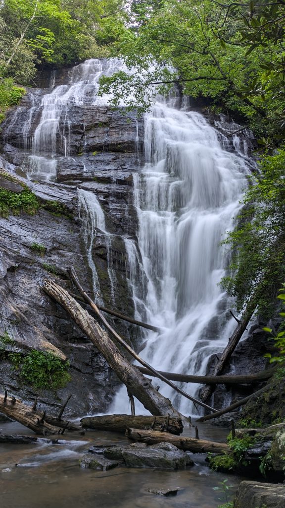
Some thoughts and findings from the FHT: Aside from the bear drama on the 3rd night, carrying into the 4th, I had a great time and really loved this little trail. The abundances of waterfalls, creeks, rivers, bridges and signage was astounding. This collection of waterfalls were exceedingly better than any I saw on the entire AT, and probably better than on any other trail, save for the Hayduke…but that’s really comparing apples to oranges. I guess Te Araroa had some really nice waterfalls too. But to find so many in such a short period on the FHT, it really was noteworthy.
The Far Out guide was extremely detailed, almost to a fault. With so many waypoints listed near each other, the app created ‘bunches’ of waypoints on the map, unless I really zoomed in. I didn’t like such a presentation (better to view in list format), but I did appreciative having abundant information. Most all the waypoints had pictures, which also helped at a particular stream crossing, helping me know that what I was seeing in the dark was correct. There are also links to YouTube videos that the FTC posted in the descriptions of most waypoints. I didn’t watch many of these, so can’t really describe in detail what the videos entailed. But it seems like the FTC provided all the information to Far Out and really took ownership in offering a detailed and up-to-date guide….for once a quality and accurate product!
The FTC also responded quickly to my bear report and does an amazing job doing trail maintenance, providing beautiful and plentiful signage, and keeping up with the heavy impact on this trail by so many users. From my observations, the users really need to step it up in abiding by LNT principles. The toilet paper and even surface poop around one of the campsites was disgusting. So to was the amount of partially burned trash in the fire pits. I don’t even have fires, but it’s so ridiculous for people to think that they can just burn trash instead of packing it out. No wonder the trail had habituated bears. It’s not the trail’s fault (after all, the FTC provided food hanging cables), nor is it the bears fault. It’s us humans. Perhaps the FTC can work with the LNT foundation to provide some educational programs for trail users. Some signage around the campsite might help too.
Lastly, while it seems you could hike the FHT any time of the year, I’m very keen to hike it again in the fall. I really enjoyed the lushness of the green trees, mountain laurel flowers, and azaleas, but I bet those waterfalls framed by the red and yellow leaves of autumn are spectacular too! Bears are also less desperate and often running scared in the fall, being chased by hunters and hounds. I’m pretty sure I’ll be back to check it out again.
Foothills Trail
Dates: May 21st-24th
Duration: 4 days
Distance hiked: 77 miles
Longest day: 30 miles, Day 3
Shortest day: 10 miles, Day 4, which was really a continuation of Day 3
Zeros/Neros: none
I left 1 food cache at mm 28, thanks to the shuttle driver Taz. This is a convenient service that he provides, which meant I only had to carry 1 day of food at the beginning and 2 for remainder. No wonder my pack felt so great!
I didn’t bother with all the other stats, since it was only for 4 days.
Thanks for following! Stay tuned for upcoming posts about the Great Divide Trail!