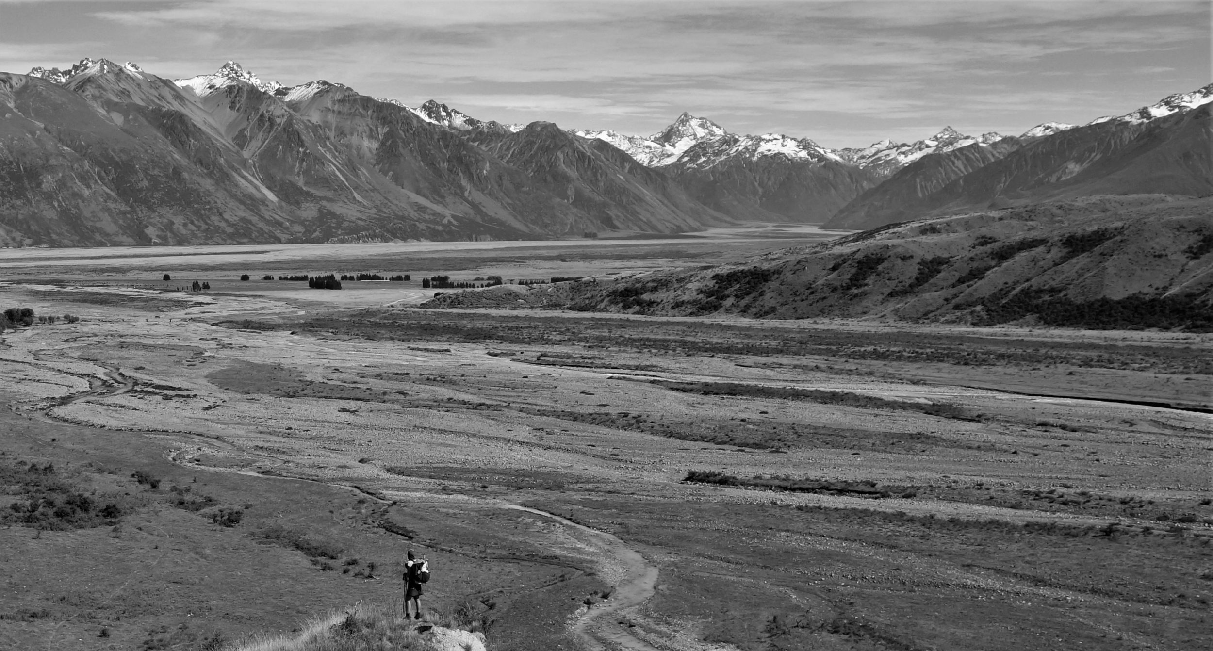
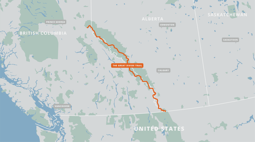
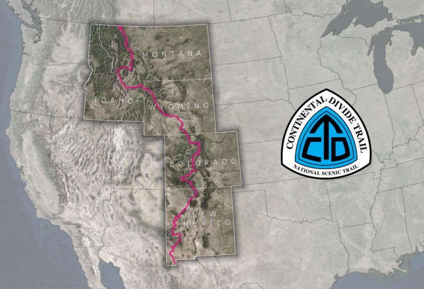
The Great Divide Trail, GDT, is a long distance hiking route that runs approximately 700 miles / 1100 kms through the Canadian Rockies, between Alberta and British Columbia (not to be confused with a bike route of a similar name). It’s also commonly thought of as the continuation of the Continental Divide Trail, or CDT, in the USA. In fact, the southern terminus lies at the US/Canada border, 4 miles south of Waterton where the CDT officially ends. The Northern Terminus is in Kakwa Lake Provincial Park, pretty much in the middle of nowhere. It’s anywhere from a 20 to 60 mile ATV road walk/hitch just get from the northern terminus to a highway that leads to Prince George and Jasper. More detailed information can be found at the Great Divide Trail Association GDTA website.
Some GDT highlights:
- High point: 2,590m or 8,500 ft at a pass in Section E
- Low point: 1,055m or 3,500 ft outside of Jasper
- Peak hiking season: July to September
- Duration: 30 to 60 days
- There are 7 sections outlined by the GDTA: A B C D E F and G
- 5 National Parks, 9 Provincial Parks, 4 Wilderness Areas, 4 Forest Districts
Here’s a list of some of the most popular and relevant pages I found for information about the GDT (and much thanks and praise to the authors who put in so much time and effort to share these details!):
Jupiter Hikes: How to Thru Hike the 1,200km Great Divide Trail
Permits on the Great Divide Trail – Part 1
Permits on the Great Divide Trail – Part 2
Great Divide Trail Hikers Facebook Group
Plus this page on the GDTA website lists almost every other blog and journal dating to the early 2000’s. I found Erin Saver (Wired’s) detailed blog to still be quite useful, though trail maintenance, reroutes and mapping apps (FarOut) have made leaps and bounds since she hiked the trail in 2015. Her descriptions of the alternates in particular are really good, for which it’s hard to find a lot of info.
What makes the GDT unique, different and/or challenging compared to other long distance hikes:
If I had to liken the GDT to any of my other 15+ thru-hikes, I’d say that I expect it to be most similar to the Pacific Northwest Trail, but obviously a lot like the CDT and certain aspects of Te Araroa (glacial/braided river crossings), as well. Here’s a bullet list of some of the most pertinent challenges of the GDT, with some that I’ll go into more detail about afterward.
- Individual backcountry campsite permits are required for all the National Parks and many of the Provincial Parks. There is no one-permit-covers-it-all, like there is for the PCT. Online reservations begin opening in January and can be fully booked within just minutes of the opening time. More than 1/3 of the route requires these permits, which means it’s still a necessity to stick to an exact schedule for the other 2/3rds.
- A lot of the trail traverses very remote areas and is often not well-marked. There are some parts with no trail at all…like the PNT. Some advanced navigation skills and experience with cross country hiking may be required, aka bushwhacking. It could also take a long time to get rescued.
- There are many alternate routes to choose from (like the PNT / CDT), which can cause some anxiety in decision-making, as well as uncertainty regarding pace.
- Many stretches between towns / resupply points are over 120 miles or 200 km (most of my food carries are 6-7 days).
- Some resupply involves having a cache delivered for a hefty price…as opposed to 10-12 day food carries.
- The weather can be just like the CDT…cold, rainy, and snowy with lightning and hail in exposed areas. There can be hazardous snow travel across high passes.
- There is almost no cell service available on trail, or even in some towns.
- There are numerous creek and river crossings. Many rivers are glacially-fed and braided, experiencing level fluctuations throughout each day, depending on rain and melt water.
- The entire route is also shared by potentially defensive or territorial North American mega-fauna: Grizzly bears, black bears, cougars, wolves, moose, and other large ungulates and ROUS’s that may appear cute but have large deadly horns, hooves, and/or teeth (still, nothing is as dangerous as a cow or Escalante Beaver:).
- For most, this is an international hike, which brings about a whole suite of additional complications….
International Travel Considerations:
While there are many more considerations for an international hike, the fact that Canada at least shares a border with the USA makes it somewhat easier. For most, a standard 3 month tourist visa is more than sufficient time to complete the GDT. For many nationalities, one just needs a valid passport to enter the country. But beware, Canada is very strict about past run-ins with the law. I heard some worrisome stories about people being prevented from entering for having felony and even misdemeanor convictions (DUI’s, but of course DT can probably still get in). I know of at least one hiker that was turned away from driving across the border, after she arrived with all her resupply boxes, fully ready to hike…. all for having a past trespassing conviction. So I guess anyone planning to do the GDT needs to have a pretty clean record…or lie about it and hope the customs agents don’t do too much digging.
Also, carrying and mailing stuff to Canada is still much more of a pain than domestic travel. Reportedly, hikers can bring commercially packaged food, but no personally-made dehydrated meals. Normally I would just ship some resupply boxes to points along the trail…this is pretty much a must for parts of the GDT. But I didn’t want to risk shipping from the US and the boxes possibly being held-up or confiscated by customs. I read plenty of accounts of hikers driving into Canada to bring all their food to mail from there. This is certainly a great option, if it weren’t that I lived so far away…driving from Miami would be like…just no. So my only other options were to carry some food with me on the plane and buy the rest in Calgary, shipping it to the respective locations from there. Oddly, Canada seems to be lacking certain things like every thru-hiker’s favorite: packet tuna. Sure, they have cans of tuna but I refuse to pack out cans, so I’ll be carting a ton of tuna packets in my checked bag.
This will be my first hike outside the USA since 2017, when I did Te Araroa in New Zealand. At least I don’t have to take a 22 hour flight to get there. Instead, I’ll be flying from Miami, connecting through DFW to Calgary, and hopefully arriving by noon the same day! Since I get a free checked bag, I’m bringing a huge bag loaded with food. I have just one day to put my resupply boxes together and get them shipped, so I’m going to be scrambling like mad as soon as I get in. That’s assuming my checked bag makes it! I do really hope things go according to plan…I could do without some of the food but I can’t live without my trekking poles, tent stakes, and stove…all the things I can’t put in my carry-on because the TSA considers them “dangerous”. I’ll be spending 2 nights in Calgary with 3 of my hiking companions (Woody, Vince and Georgie Strawbridge), then we’ll all be taking a 3 hr shuttle to Waterton the next day. These arrival logistics are relatively easy, especially compared to the return.
Permits:
It seems like my hikes keep going from bad to worse when it comes to permits. The Triple Crown trails were SO EASY compared to the hassles with permits on the PNT and Hayduke. To say the GDT is logistically complicated would be a great understatement, because it far exceeds them all. In fact, I found the permit process to be so exasperating, prohibitive and expensive, that I almost gave up on the GDT entirely. If it hadn’t been for the option of joining Woody on his itinerary, I might not have done it at all. I mean, imagine a 2 month thru-hike where you have to plan every single night 6 months in advance, that sounds crazy, right? Not only that, you pretty much have to be waiting with multiple devices logged in at the exact moment of reservation openings, just to be ready to scoop up the most popular sites. They go within seconds! Even still, you might spend months trying to trade sites with others for the ones you needed but couldn’t get, like baseball cards. Plus, the price-tag for all these sites ended up being over $400, half of which went to online administrative fees!
Frankly, the cost, complications, and competitive nature of this process is ridiculous, but hundreds have been willing to jump through these same hoops, so I guess it’s just the way it is. It would be really great if Parks Canada began to offer a thru-hiker permit, but that seems unlikely…why make something easier when there’s already so much demand for it? As I previously eluded to, I actually bypassed the worst of the process by riding on Woody’s coattails, so I can’t really complain that much, nor can I detail exactly what the entire reservation system is like. Fortunately there are some very dedicated people providing all that information in the links I listed above, so no need to repeat it all here.
As Jupiter summarized well in his blog, “This trail can be as hard and as logistically confusing as you want it to be. So if you want as simple as it gets, buy the permits exactly for the dates in the GDTA example itineraries with a bunch of zeros thrown in, start at Waterton in mid July, hitchhike to towns often for resupply or to avoid storms, buy a super quality rain jacket, and end at Jasper or Mt Robson.” There are 3 example itineraries – Relaxed (68 days), Average (50 days—that’s us) and Fast (36 days), detailing every single campsite that one would use based on a given pace. This makes it easy to simply book campsites according to the plan, kind of like following a recipe. There’s even a nice populated spreadsheet one can download, with all the distances and campsites pre-programmed, ready to be adapted to your own schedule.
For a bit of background on my hiking companions and how it came about that we all teamed up for this adventure, read on: I met Woody in April 2023 as I was hiking the Hayduke outside of Kanab. He was caching water for a section hike of the Hayduke and gave me a ride into town. In January of 2024, when I was just starting to contemplate the GDT for the upcoming summer, I saw a post he made on the FB page. I reached out to him to ask about his plans and pretty spontaneously opted to go along with the itinerary he already had worked out. All Woody had to do to add me while making the reservations was hit the +1 button for each site, plus type in my name. Parks Canada stipulates only one tent per site but up to 4 people…doesn’t make a lot of sense but we decided it was best to book 2 sites for each night. But at least we were able to split the administrative fees for all the reservations, so it worked to both our advantage. I would highly recommend that future GDT hikers consider teaming up with others, to combine efforts and costs. This makes the permit process much more tolerable.
Forming a hiking group (tramily) also makes sense in regards to grizzly bears. I never worried about them much on the PNT or CDT, but this was one of the things nagging me about the GDT, which solidly traverses areas where they are very prevalent…the whole way, in fact. According to the experts, there’s never been a confirmed grizzly attack on a group of 3 or more people. So only a week or so after I joined Woody’s plans, our tramily grew. During the first week of February, after about half our reservations had been booked, I ran into my friend Vince at the Florida Trail Billy Goat Days. He told me how his youngest daughter, Georgie, was just graduating high school and wanted to take a gap year to do more hiking…specifically the GDT. Mind you, they both already completed the Triple Crown (PCT, CDT, AT), along with the rest of their family of 6! I met them on their first thru-hike of the PCT in 2018.
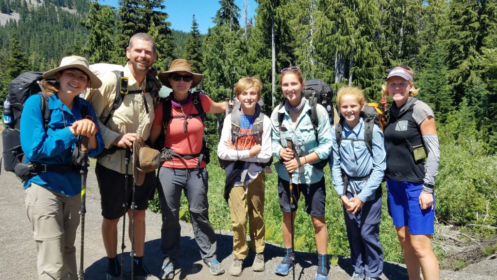
At first I told Vince that they were probably too late in starting their planning but then I wondered, couldn’t the 2 of them just join us? The more the merrier. So we started reworking some of the already booked permits as best we could, and adding them to the new ones. Before I left for 3 weeks to raft the Grand Canyon in late February, we’d purchased plane tickets, made all the hotel and AirBnB reservations for towns, and had most of our permits set…mostly all non-refundable. I’d never sunk so much money and made so many commitments so far in advance of a hike, not even for New Zealand. I even bought travel insurance, which seemed like a wise idea.
Gear:
I guess it was nice to work out so many of the details early on, freeing up time to focus on my Grand Canyon Rafting trip and other smaller hikes of the Benton MacKaye Trail and Foothills Trail. All I had left to do in the month preceding the GDT was get my food resupply and gear items in order. Speaking of gear, I used the aforementioned trails to do some testing and decision-making about what to take to Canada. Like New Zealand, I really wanted to have my gear list dialed in, since it could be very complicated and/or expensive to replace/swap out items once on the trail. The biggest recent changes I made were with my tent and backpack.
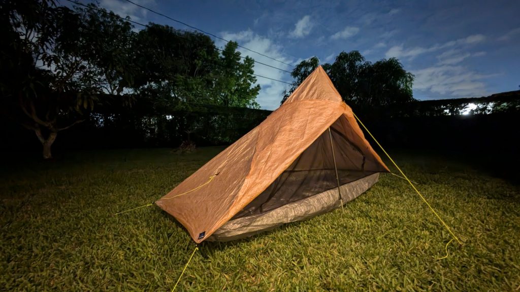
Thankfully my Zpacks Plexamid tent (which I started using until 2022) decided to spring a leak on the BMT, and not once I got to Canada. I was able to talk with the Zpacks reps at AT Trail Days to address the issue, which ultimately resulted in a (like)-new Plex Solo tent. I’m so grateful this all worked out the way it did, because I feel very confident it’s going to be a bomber tent to keep the Canadian rain and bugs at bay. A huge thanks to Zpacks (especially Jamie) for working with me on this! But I am going to miss the long reign of my Zpacks camo tents…carried on every hike since 2016!
I was very on the fence about which of my backpacks to take on the GDT. I knew my HMG 2400 Windrider was the most appropriate pack for the job, given that I planned to be carrying 6 days of food for most sections. I used that specific pack for the Hayduke and its predecessor, an HMG 2400 Southwest for almost all my other thru-hikes up until the AT. But I really wanted to make my new Waymark EVLV Ultra 38 work, mostly just for the bragging rights of rocking a frameless and beltless pack. I tested it for the first time on the BMT and within days, had changed my mind. Something about this new pack just didn’t work for me. Mainly, the shoulder straps were a bit too wide and rubbed my rotator cuffs. So I planned to go back to my Windrider. But then the HMG reps at Trail Days sold me on one of their newest packs, the Waypoint 35.
Why did I get another HMG pack when I already had a perfectly good one? Well, this new design had all the things I liked about my old HMG packs, and none of the things I didn’t. For starters, the side pockets are greatly improved, extending down to be flush with the bottom of the pack (one of my biggest gripes about the old packs). The interior is quite generous (way bigger than my Waymark 38) and the exterior pockets aren’t included in the 35L calculation, so it’s more like a true 40L pack. It has a single stay for the frame (instead of 2 like the original HMG packs), a removable hip belt, no velcro on the roll top, no hydration port, 2 integrated shoulder pockets, a stretchy mesh back pocket, a stiff padded back panel that maintains the shape even with the frame removed, and lots of other simple, lightweight details.
So far I haven’t even cut anything off it! I had a hard time deciding between the HMG Contour (frameless and no hip belt) and the Waypoint, but decided on the later since it was much more versatile…I can remove the hipbelt and frame to shave some weight for my lightweight hikes, then add the support back when I need it. I used the Waypoint 35 on the Foothills Trail and it felt awesome…granted I wasn’t carrying hardly any food. But I just packed it with most of my gear for the GDT, plus 5 days of food, and had no problem fitting everything. I’m very excited about both this new pack and tent.
I also have to give a shout out RE: my ZOLEO satellite messenger device. Vince worked out a pro/family deal for which they sponsored us with 3 full service plans and devices! I already got a good test-run out of it on the BMT/FHT, for which it was nice to be able to send messages during a severe thunderstorm. The ZOLEO has been SO MUCH EASIER to use than my old Garmin InReach, which I ultimately got rid of because it was overly complicated. ZOLEO gives users a dedicated phone number that anyone can text, as well as an email address that anyone could also write to (message me through Instagram @twigadventures if you want the number/email). The phone app syncs with my contact list and displays messages just like any texting app. It automatically switches to mobile and data services when available, relaying messages seamlessly, even if the ZOLEO device is turned off. When out of cell or WIFI range, I can turn the ZOLEO on and start receiving messages via satellite.
These devices are going to be key in keeping in touch with each other on the trail and with our families back home, since there is almost NO mobile service along the way (not to mention the fact that our mobile plans probably don’t work at all in Canada!). Also, there are several times that we might need to be able to communicate with the resupply/shuttle outfitters…they can’t or won’t provided such services unless someone in the team has a Sat messenger. And obviously the ZOLEO would be invaluable if we had an emergency because it has a dedicated “hot” button to push for an SOS, which would automatically send our position to be relayed to nearby authorities and notify our emergency contacts. We’d be able to communicate with rescuers about the nature of our emergency and the rescue timeline. But let’s hope we don’t have to test that particular feature! Regardless, we are incredibly grateful to ZOLEO for providing this asset to our team!
The rest of my gear list is mostly the same kinds of things I’ve carried on all my other thru-hikes, with a few notable exceptions: I’m using a full set of alpha-direct ‘pajamas’ as my sleep clothes and warm layers. I’m not stoked about the low durability of this fabric, nor the fact that it’s basically see-thru, but it’s stupid lightweight and warm. I fear my 30 degree quilt may be a little too light for the conditions, but I’ll also have my puffy to add to the mix. I’ll be carrying bear spray for the entire trail, plus an Ursack. I had a good run of over 17k miles with no bear problems…right up until my most recent night on trail, when I had 4 habituated juvenile black bears giving me the run-around. I don’t want any more bear issues the rest of this summer, so I added some of the best gear and strategies to hopefully prevent any more negative encounters.
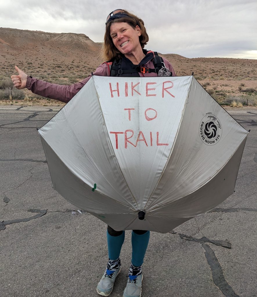
As for rain gear, well, I don’t have the best jacket but OF COURSE I’ll have an umbrella, which more than makes up for the rest. I’m using HMG’s rugged new “essential” umbrella, which has sophisticated air vents that allow up-welling air to escape, preventing it from being blown inside out. Hopefully this works better in windy conditions…we’ll see. Thanks to HMG for giving me the opportunity to test it…I won’t let you down!
Well, there’s so much more I could write about resupply, section descriptions, navigation strategies, etc, but this post is already way too long. Much more will be revealed as I hit the trail. I’ll note that if it isn’t already obvious, we’re hiking the GDT northbound (NOBO). Like most popular trails, this is the direction of choice for the vast majority of GDT hikers. As much as I like flip-flopping and going SOBO (rogue), I have to admit that this direction makes the most sense for the GDT. There’s already a very short weather window in Canada and we need to work with the spring melt in our favor. From what I’ve researched, the river crossings get progressively more difficult as you go north.
If we were to start at the northern terminus, we might need to wait for another 2 weeks to a month for the rivers to come down. The northern sections are also the most remote and difficult, with the longest food carries, so it’s not the best place to be breaking in new gear and feet. Just getting to the ‘trailhead’ would be a challenge…one we’d rather leave for the back-end, once we kind-of have other things figured out. One of my most recent hikes, the BMT, was officially my first NOBO thru-hike, so at least I finally broke that barrier and can move on. LOL…SOBO in spirit and for life.
Excited for your grand hike my friend. So
Grateful we got to connect recently. I have missed you.