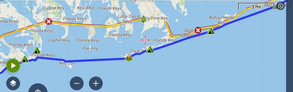
Day 5: Monday January 26, 2026. Distance: 23 miles to Jumping Bridge, Lower Sugarloaf Key. Stops: Bahia Honda SP, Big Munson Island, Key Lois…Monkey island!
Despite everything being wet, I was up before the sun, packing like mad as soon as I left my tent because the no-see-ums were absolutely destroying me. I guess these islands have their own self-defense mechanisms to repel intruders. I shoved off in the dark, eager to paddle fast to rid myself of the evil wings and teeth. It was also crucial to get an early start this day, as I needed to beat a winter front. I wished I’d had more time to enjoy Molasses Key, but at least was very content with my first visit. It still provided the perfect stop-over on this trip.
The morning was dead calm and I enjoyed the sunrise over my shoulder. It was great to be witnessing it on the water, like so many times before that I’d stood watch on a ship. I’d planned to head to Little Duck Key to use the bathroom there, but was feeling energetic and figured it could wait until I reached Bahia Honda. The 6 miles flew by. It’s so easy to cover distance when the ocean is so smooth. I relished this reprieve, especially since I knew it would be gusting into the 20s and maybe even 30’s by days end. The calm before the storm.
Bahia Honda was a crucial stop, as it was the last place I could easily refill my water containers for the day, and basically the rest of the trip. But I also just wanted to enjoy this beautiful state park for a bit, as it’s perhaps one of the most striking in all of Florida. My NOAA research group used to stage from the marina when we were conducting reef fish census in the area and it was always one of my favorite locations. The waters are so blue and the nearby snorkeling and diving really great. The original railroad bridge provides an impressive backdrop, as it’s arguably the most picturesque of the old bridges in the keys. I’d always wanted to camp at the park, but the location and views make it highly prized and hard to reserve. But they do have one site that’s held in reserve for last-minute vagabonds like me. The timing didn’t line up for my kayaking segments, but I planned to hit it on the walk back, for sure.
I passed a Portuguese man-of-war on the way into the beach. I like to call them by their genus species name because it sounds so cool: Physalia physalis. Not surprisingly, this has also been adopted as a popular name for sailboats. Despite being quite venomous and painful, they are intriguing organisms…actually a colony of siphonophores and not an individual jellyfish, as most would think. We were both drifting about this day, only I was moving with much more intent. I hit the beach, ran to take a shower, and filled all my water containers. The were 2 competing interests at odds in me. One wanted to hang out, enjoying the beautiful morning. The other wanted to utilize the calm weather to make miles. After briefly talking to a tourist couple on the beach about my journey, the latter eventually won out, and I was back in my boat.


The views of the bridges distracted me as I easily covered the span to Big Pine, hopscotching my way along a series of small beaches and islands. Look at a map of the lower keys, and you’ll notice that the islands start running in a north/south direction, as opposed to the upper and middle keys that stretch more east to west. As such, there are many miles of coastline to follow in the lower keys, but not as many that will carry you to Key West in an efficient manner. The lower ‘shoreline’ kind of peters out for a bit between Big Pine and Sugarloaf. One could paddle north and south to follow the contours of these lower keys, but this would add significant distance. Not to mention, the inner areas are incredibly shallow and can be challenging to navigate. One could also head north, skirting No Name Key and stringing together the labyrinth of small keys that make up the Nation Key Deer Refuge. But that route is also longer and in my case, would have exposed me to the north winds that were set to blow by day’s end. So I decided to stick to the most straightforward and efficient course, making the 8 mile jump across the big gap. I knew it was going to be taxing on it’s own accord but then, right on cue, the west wind started to pick up, blowing in my face. Perfect.
Winter fronts produce a predictable series of wind shifts, which mariners refer to as “clocking” or “veering” winds. Even without the modern conveniences of forecasting apps/websites like Windly and NOAA wx, a salty dog can easily read the winds to know they are in for a big blow. Noting the shifts over the past 2 days from E to SE to S and today SW to W, I experienced this phenomenon first hand. I knew it all too well and that it didn’t bode well for a kayak. I wasn’t sure how far I’d get this day, with my back-up plan to stop short somewhere along the Big Pine beaches if need be. But I really wanted to cover the big gap before the front moved through and the winds gusted from the north, as I knew the crossing would be an absolute bear in those conditions. I’d be so happy if I could make it as far as Sugarloaf. From there, a fairly continuous shoreline existed, which would protect me from the north winds, all the way to Key West.
My focus paid off, as I made it to the east end of Big Munson Island before noon, seemingly ahead of schedule. It was all systems go to continue to Sugarloaf, I just needed a well-deserved lunch break. Maybe it wasn’t technically legal to land on this private island, owned by the Boy Scouts of America, but I really needed to refuel and get out of the sun for a bit while I could. It was really hot and I didn’t think the scouts would begrudge me a layover, especially on the undeveloped side. I took some time to explore a few of their trails as I snacked on my food.
Leaving my lunch spot, I had another mile to work my way along the long island and the final 8 mile open water stretch. I aimed for the distant and offshore Lois Key, as I intended to utilize the shallow waters for a pee break. I began to battle an increasing west wind, which gave me all the more reason to head for Lois, in order to get a little bit of a lee. I took a short pause there and pondered the history of the place. Apparently one Charles River Laboratories, part of the Bausch and Lomb company, used to raise rhesus monkeys on the island, to later be sold for medical research. From the 70-90’s, there were thousands of monkeys on the island and several structures. The monkeys overpopulated, destroyed the mangroves, and caused a toxic situation in the surrounding waters. A judge ordered the closure of the facilities, removal of the monkeys and restoration of island by the late 90’s. Rumors still abound that you can see remnant monkeys, but I saw no evidence of them. All that I passed were a few derelict boats. What an interesting background, though.
I pressed on for my final 3 miles of the day. The west wind was blowing 10-15 kts in my face at that point, throwing up lots of spray and bouncing my bow around in the 1′ chop. Luckily I find it pretty easy to counteract a headwind with a greenland stick and my kayak is also very snappy going into the seas, inspiring confidence and even a bit of joy riding. I much prefer it to beam seas. I watched as a prominent front line of dark clouds edged closer. Then they started dipping down, looking like funnel clouds. It was really cool to see but also a bit disconcerting, given that I was still about a mile offshore. I had no choice but to keep paddling strong, my goal in sight. The winds died briefly, giving an eerie stillness to a scene that otherwise looked ominous and chaotic. I knew this pause signaled a significant and immediate wind shift and sure enough, just as soon as the other edge of the cloud front passed me, the north winds hit me like a brick. Thankfully my timing couldn’t have been better, as I’d just reached the cover of Sugarloaf Key. Whew! If I’d been even 15 minutes later this day, I would have really been struggling to reach the shore!
I hugged the shoreline as close as I could for the last half a mile, thankful for my shallow draft and the medium tide. As I’d discover the next morning during low tide, these lower keys have incredibly shallow shores extending outward for hundreds of meters. I came to the inlet to my destination for the night, still not sure what I’d find there. The old SR 4A road, which used to be a part of the Overseas HWY but is now a dead end, creates a local landmark called the Jumping Bridge. There were lots of pictures of it online, from which I was able to see that camping was possible…but would there be an area protected enough from the wind? If not, I’d need to paddle another 3.5 miles to Sammy Creek.
The temps had dropped as soon as the front hit. and it looked like it was about to rain. I wanted nothing more than to be off the water for good this night, getting warm and dry inside my tent. My bet panned out, as I found a decent spot protected by the raised road bank. It was a little ways away from where I was able to haul my kayak out of the water and I also wanted to hide my boat from the view from the bridge. Here’s where my kayak cart finally came in so handy, as I was able to wheel the kayak and gear inside right to where I set up my tent. I was so thankful for my protected spot, safe from both the sea and winds. Sadly the weather did not accommodate any jumping from the nearby bridge, but at least the gale blew away any bugs that might have bothered me! I read reviews that said the no-see-ums were terrible most of the rest of the time in this location. It actually ended up being a great campsite because for once I couldn’t hear the US1 traffic noise. I slept the most soundly I had the whole trip.


Day 6: Tuesday January 27, 2026: Distance: 16 miles to Boyds Campground, Stock Island (Key West). Stops: Sammy Creek Landing & Boca Chica.
The wind howled all night, not reaching my tent but making me nervous about the remaining distance I had to paddle. At least there were only a few small gaps exposing me to the north winds this day, namely the Boca Chica channel. I’d reach it after noon and by then, the winds were supposed to have come down. I set off down the creek, not yet experiencing the full the strength of the wind. Man was I lucky to end up where I did the night before! I reached the ocean and began a delicate dance in navigating the interplay of the low tide and shallow waters while remaining as close to the shore as possible. Looking south to the open ocean, I could see the giant waves cresting, sure to swallow a small vessel like mine. I wasn’t sure how likely it would have been to get blown out to sea, but I wasn’t about to loose my grip on the shore, even if it meant slogging around in the seagrass flats for hours. Other boaters were at a loss, as I didn’t see a single boat or ship underway all day, at least not until I reached Stock Island. I was the only one crazy enough to be out, but I suppose I was also the only one capable of staying close enough to the shore to safely avoid the wind and waves. Wind driven waves are based on the strength of the wind but also fetch (the uninterrupted distance the wind blows over the water) and the depth. I was effectively able to eliminate the depth and the fetch.

I paddled along this fine line for miles, enjoying a bit of surfing and fast paddling due to an easterly component in the wind. I took a short break at Sammy Creek Landing, then continued to pick my way past the Saddlebunch Keys. I worried needlessly over a few small crossings like Geiger channel, as there was nothing exposed enough to result in big waves. After reaching Boca Chica, on a whim, I decided to explore Geiger Creek for about a mile, relishing the tranquility of the mangrove tunnels. I saw lots of fish and a few sharks. Finally, as I rounded the corner of Boca Chica, I could see the whitecaps across the channel. This was to be my big challenge of the day and it looked a bit scary. But I spied a series of stepping-stones on the chart, little islands where I could find a lee and break the crossing into smaller chunks. The first part was the roughest but I never felt like I was in any kind of danger. It was over in a minute and then it was just slow going as I worked my way up the channel to Boyds Campground, finally getting a decent lee from the main causeway. And just like that, the kayaking portion of my journey was over, without even a good finishing photo of me with my boat, as there was no one around to take it.


Of course it was my intent to complete a circumnavigation of Key West the following day, solidifying my claim to having paddled all the way. But alas, the winds were forecasted to blow for the next several days and it was also going to be rather chilly, with lows in the 50’s and highs only in the 60’s. I would have needed to brave the full force of the north wind for many miles, dealing with rough seas, possibly among other boat traffic. I could have just paddled the south shore to where the southernmost marker point sits, but then the logistics of picking up my kayak would have been a lot more complicated. I didn’t know what the parking and kayak loading situation might be like in that area, as it’s incredibly touristy, crammed with people, buses, cars, etc. I also didn’t know if it was possible to land on the beach there…of if there even was a beach. A lot of the Key West waterfront is the domain of snooty high end resorts.
So I didn’t even make it all the way to Key West proper, as Boyd’s is situated next door on Stock Island, but I figured I made it close enough. By ending my trip at Boyd’s, I was able to rinse down all my gear, dry it, and get it stowed for pick up the next morning. This way, I’d be prepared to start hiking as soon as Monica arrived with my car and change of gear. I was also able to stay with my kayak overnight… the only place for miles where I could camp with it. Even if I’d found a trail angel to stay with in Key West, I still would have faced the problem of where to leave it. Paddling logistics are way more complicated than backpacking! It cost me a record amount for my tentsite ($95!), but it was really the only feasible option. I made the most of it by enjoying a hot shower, doing my laundry, and cleaning everything so that I wouldn’t have to do it when I got home.
I also made friends with my neighbors Mike and Carmen, who were staying a few days in their van. They were the sweetest, offering to make me a hamburger. Of course I said yes and we enjoyed having dinner together, swapping stories of our travels. Being a mom, Carmen was worried about me being warm overnight, so she even lent me a blanket. I didn’t need it but it was nice to have it as a backup. Everyone was so friendly, I was really glad I stayed at Boyds, even if I was a bit out of my element. I think I was the only one that slept in a tent that night, as all the other patrons had RVs and vans. I was also the only one with a kayak as my main source of transportation.