Saturday, March 22nd, 2025, 0600-1840
Near Cedar Creek Falls TH to San Vicente area, mm119.5, Elevation 1370′
18 miles.
Oh boy, what a day. When researching this route, about all I heard mention of was the horrific bushwhack up the backside of El Cajon. But of course, I never knew if the severity described by others would live up to my expectations. Certainly the extent of my bushwhacking experience through vast deserts, canyons and dense PNW forests raised my bar pretty high. But as I’d already noted, bushwhacking through thick chaparral sucked pretty hard, too. I’d watched a video from another hiker long enough to know how I was going to handle some private property reroutes through the chaparral…as in, no way in hell was I going to bother doing them. I’d rather take my chances walking the semi-private roads. As such, I got an early start to hopefully take advantage of a quiet Saturday morning. I also hoped to avoid the mid-day heat on the climb to El Cajon.
I’d strategically camped right at the outskirts of the Four Corners development, so I was taking a crack at it first thing, but also immediately thrown into a world of uncertainty. The truck road I’d been following basically dumped into the backyard of several residences. My GPS route suggested a nearly 3 mile bushwhack bypassing the whole development to the south, but I knew better than to attempt this. I decided to risk being shot and/or attacked by dogs by trying to navigate through the development. Google maps indicated that the grid of roads making up the community were public…it was just a question of how to get to these roads from where I stood, without raising the ire of some resident. My plan was to move fast, keep my head low, and hopefully not attract attention. This proved to be all but impossible given that this semi-rural development was basically a giant dog farm, but initially the dogs weren’t expecting me to come from the boonies.
I can’t quite recall exactly how I skirted past the first set of properties. I think I followed the Gower Truck trail where it turned south, then cut west along what seemed like an easement next to a fenced property to reach a public N/S road. I followed it until it hit a main E/W road and turned west. Then I turned south onto Live Oak Trail to regain the route where the road dead-ended into another property. This last part was definitely the most blatant part of my trans-pass (my term for trespassing on the TRANS Country Trail, get it?) through Four Corners. Lucky for me, the property was under construction, which on a Saturday morning was temporarily paused and seemingly deserted. I walked right past the empty little guard shack? and down the hill to pick up the old, closed-off El Capitan truck trail. I didn’t care if there were cameras (likely), since I figured I’d be long gone before anyone had a chance to view the footage. Just in case, I even pulled my buff over my face. Whew!
No cars passed me and no residents seemed to notice me the entire time, besides the herds of dogs. Seriously, I’ve never seen so many giant properties also defended by giant dogs, mostly Great Pyrenees (the big white scary ones that usually guard sheep). Thankfully all the properties also had big fences to keep said dogs in, or I would have been in serious trouble! From the moment I set foot on one of the main roads, all the dogs were on notice due to their network of barking. The dogs on each adjoining property would chase me down their fence, then pass me off to the next set of dogs. It went like this for the 40 minutes it took me to slide through the area. One property had tons of other barn animals, which also started up a riot…donkeys he-hawing, chickens clucking, etc. Besides all the noise and my worry over getting in trouble, the walk was kind of pleasant. I enjoyed seeing all the nice ranches and horse farms. I’d bet it’s pretty nice to live there, but predators and bandits better watch out!
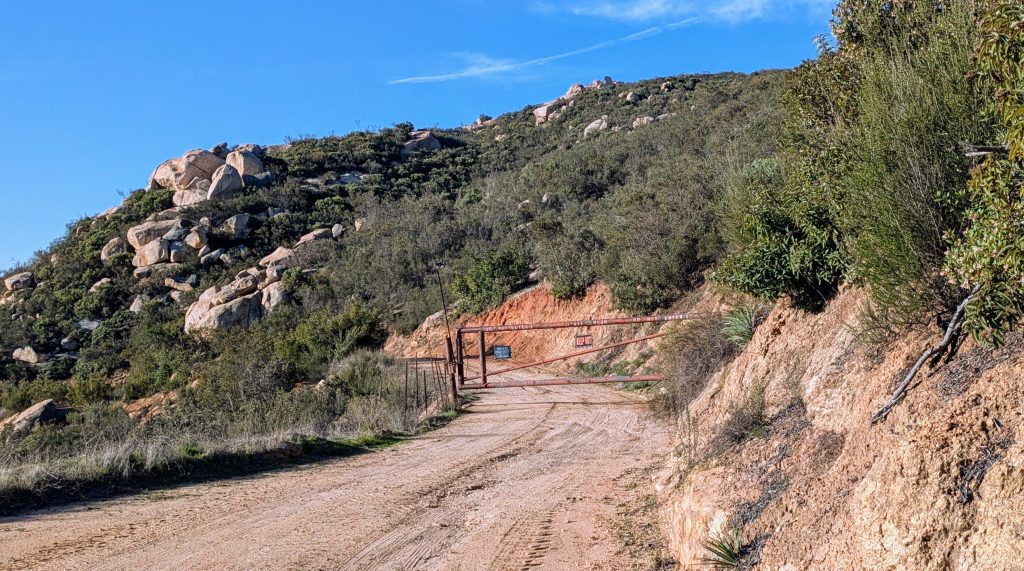
Upon making it to the truck trail, I had about 2 miles of easy, worry-free travel before I came to another situation. I still wasn’t entirely clear about the specifics, but it was reported that a guy lived along the road and took serious offense to trespassers. Oh and one other minor detail, the road also passed through the NW edge of tribal land for about half a mile and was therefore private through that stretch. As such, the road was gated, with aggressive signs and a camera. Here again, I was to reroute around, bushwhacking up the side of the hill and along the border of the tribal land. Well, I did bushwhack for a spell, just long enough to avoid the gate but also determine that trying to press forward though the insanely thick brush wasn’t happening. So, officially I gave up, turned around and avoided the whole ordeal entirely. Or perhaps ten minutes on the road and I was clear of the area. Who knows what I did. But I never saw anyone and left no trace, so I guess it never happened.
In another few miles, I had to say goodby to the pleasant dirt road and begin the bushwhack from hell. There was no getting around it this time. There was a trail on the west side of the mountain, so it was just a matter of connecting to that trail at the summit. But about a mile and half of thick chaparral and a steep ridge stood in the way. I guess there was another option, and that was to have left the route back at Four Corners and walked/hitched down Wildcat Canyon Rd, bypassing El Cajon entirely. The road was described as extremely dangerous, but would have certainly avoided almost all the problems of this day. Most would probably be best served by taking an Uber down the highway. But I was not one to shy away from hard things, and now it was directly in front of me.
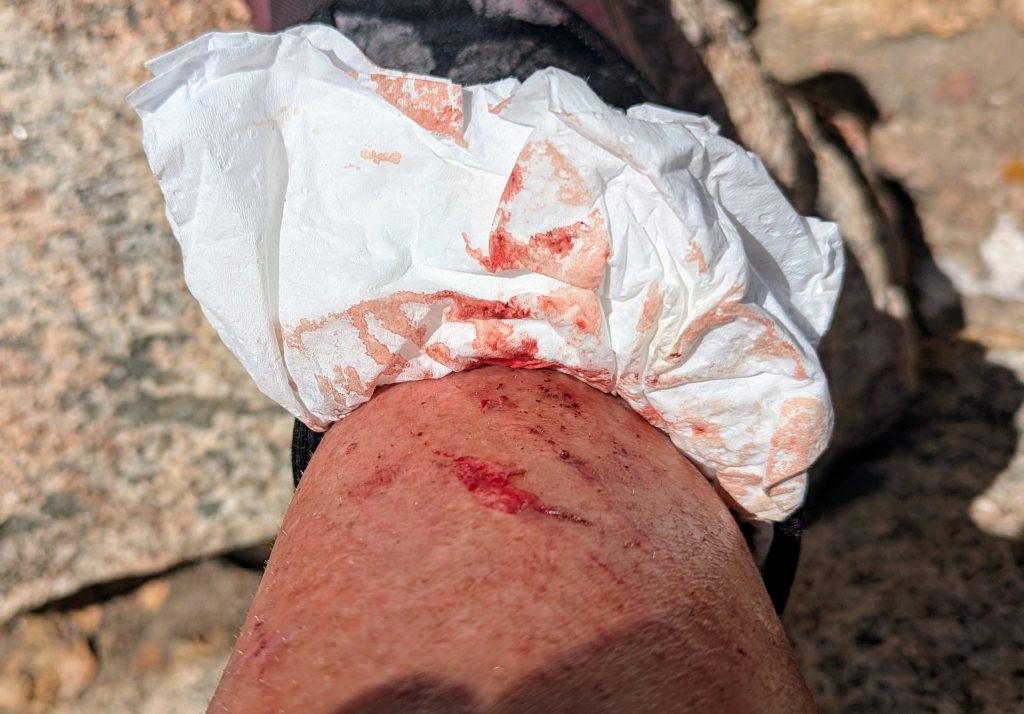
Note to self, I knew ahead of time that this was going to be a bad bushwhack and should have brought some jeans/canvas pants to wear during it. I could have gotten a pair at a thrift store in Julian. But I didn’t and upon starting the bushwhack, knew for certain that my legs were going to get F’ed. All I had for pants were my Alpha Direct camp pants and my paper-thin Montbell wind pants. Either would have been shredded in minutes and done little to protect my legs. Next time I’d be better prepared but this time, I decided to just embrace the brutality by stripping down to only my dress. Yes, I even took off my sun shirt to avoid any damage to it. Why not have matching arms and legs?
Route finding was at least pretty easy. I followed a series of ridges and even found a few cairns along the way. At times there was even a slight trail, or at the very least I could tell where others had tamped down the brush somewhat. I was well aware of the horrors of manzanita, which should be avoided like the plague, so I predominately pushed through a type of shrub called chamise. It gave-way decently, but was scratchy. At first, the scratches were no big deal, but the constant friction added up to some very raw skin. Still, it could have been MUCH worse. None of the shrubs had thorns or urushiol toxin (poison oak)… either would have been a deal-breaker. Scrub Oak was also thankfully not present…that shit can be near impossible to push through.
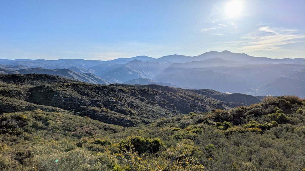
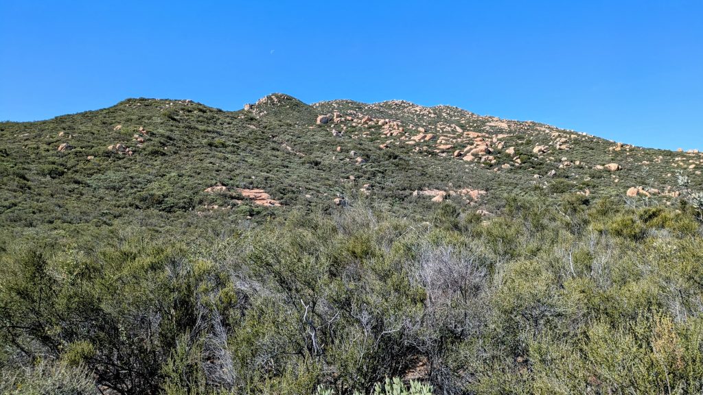
I took several short breaks to enjoy the views. The surrounding boulders and greenery were also beautiful to behold, when zoomed-out. I pondered the route I’d followed, which was mostly visible all the way back to Mt. Cuyamaca to the east. Very cool. I also saw a fox along the way, but unsurprisingly, nothing or no one else. I did get mired in a few bad clumps of manzanita, which started to test my patience. Generally the shrubs were only waist high, but there were patches that went over my head. In those moments, I thought I might get permanently stuck, swimming through a sea of unyielding branches. Having a backpack on made things even harder. I streamlined it as best as possible, even sticking my umbrella down the center, inside. I also put my trekking poles away, as they only served to get more entangled in the shrubs, rather than being of any help. But somehow I kept pressing forward and after about 2 hours, found myself standing at the summit.
The best part was seeing the look on some military guys’ faces. We’d caught sight of each other when I was still about a quarter mile from the summit. They were sitting on top of a boulder, just watching me make my way slowly towards them from below. They must have been wondering, “What the Hell?” Thirty minutes later, I emerged from one last battle with a manzanita bush, with blood gushing down my legs, Rambo-style. They were still sitting atop the boulder, mouths agape. The silence was awkwardly awesome. They didn’t say anything and I didn’t either. We just stared at each other. Then they simply got up and left. Seeing some crazy lady in a dress and backpack, legs covered in scratches and blood, emerge from the side of mountain would have probably put me off, too.
At this point, I was down to my last liter of water, it was past noon and pretty hot! But I wasn’t too worried. I figured I could always bum some off a day hiker if I got desperate enough. But I didn’t since there were springs on the way down. I spent over an hour at the top, because surely I’d earned it. I tended to one particularly deep gouge in my leg, marveling at how my gaiter had turned crusty from all the blood. But mostly I just took summit photos and enjoyed the fantastic views, managing to do some great peakfinding. I could see downtown San Diego, San Jacinto, Mt Baldy and Mt Cuymaca. I could also see very clearly the Pacific Ocean! El Cajon was kind of like my Katahdin at the end of my long journey across the desert. I made it and it would all be smooth sailing to the coast from here on out!


Except that I didn’t know what a LONG, steep and slippery/rutted 5 miles down (and even about a mile UP) the west side of the mountain that I still faced. Regardless of the length and difficulty, it was still better than the 1.5 miles I’d just done. I left the summit around 2 pm, realizing I was going to have a pretty low-mileage day. But that was fine, I was just so happy to be done with the bushwhack! A few miles down, I struck up a conversation with a couple who were wearing some obvious thru-hiking gear. Locals Andrea and Rick had section-hiked parts of the PCT and were a joy to talk to. I was just so glad to have some company, the first and only people I hiked with along this route. It made the miles and time go by fast.
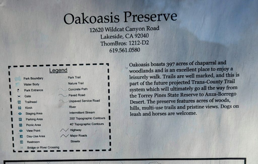
A reward of a privy, water, and a farm stand with grapefruit and tangelos greeted me at the trailhead. I had no cash, but luckily was able to pay for the fruit using Venmo. It tasted so good while I took a break in the shade. I contemplated camping near the privy, but decided to press on. I froggered across a busy Wildcat Canyon Rd…yep, seemed pretty dangerous, and entered OakOasis preserve. The route led right through the campground, where I lingered to ask a ranger if perhaps I could stay there. There was a boy scout troop camping, from which I also managed to yogi 2 apples by telling them my crazy story of crossing the desert. I’m sure they didn’t believe me, but I really appreciated the apples!
One of the adults was just preparing the grill, which got my stomach growling. But I didn’t want to press my luck, plus crashing their campout would have been poor form and also against policy. The ranger made it very clear that they couldn’t allow strange weirdos to camp with the kiddos, which I understood completely. Still, it would be nice if the preserve at least acknowledged SDTCT thru-hikers and reserved a small space for them to camp. After all, they’d posted a sign acknowledging the trail itself. This is all-too typical of these routes…a passage may or may not exist and be sanctioned by various authorities, but certainly almost no thought is ever given to camping options for thru-hikers (like many parts of the Oregon Coast Trail).
On the topic of where to sleep through this section, many past hikers made use of nearby hotels and AirBnBs. I could have tried to Uber back to Otzi’s place in nearby Alpine or stayed at the even closer casino. But by necessity, I was frugal and also confident in my stealth camping abilities. I also just loved sleeping outdoors, especially as part of a thru-hike. So I pressed on once again, confident I’d find a spot. I was entering the most urban part of the route over the next 2 days, so I was going to need to be at the top of my game. The route left the preserve by way of a side road, where I unwittingly scared the crap out of a lady doing yard work in the adjoining property. She screamed and I winced, feeling bad about my presence there. I mumbled a quiet sorry and kept moving. After all the worry over my trans-passing this day, I finally managed to distress someone…but at least she didn’t shoot at me or call the cops.
Despite my one trans-gression (I’m trying to see if this post gets flagged and banned by the Trump Administration), the road walking through the quiet neighborhood was so enjoyable in the late afternoon / early evening. I loved gazing at the pretty houses, so vibrant with spring flowers! The views of the setting sun over the coastal hills were also fantastic. Apparently the route used to stay in the preserve all the way down to and along the San Vicente reservoir. But of course, construction and private property issues had eventually forced it through this neighborhood, instead. In fact, I think I was actually following a route that Buck30 had mapped for himself way back in 2010. My compass always steered in the footsteps of Buck30… all the way since Tucson, on this particular journey.
When I should have been nervous about finding a place to sleep, I was instead at peace and feeling very fulfilled from my successes throughout the day. Walking euphoria transcends many problems. Coming down the hill, the route ducked under yet another gate adorned with “No Trespassing” signs, into a partially developed subdivision. But all was quiet… again, being that it was a weekend was probably key. I hit this section just perfect, even though I hadn’t really planned it at all! Already my stealthy-camping senses were perked and I knew I was close to the spot, I could just taste it.
In a bit, I passed a vineyard venue with a view to die for, no doubt one posh and expensive place to have a wedding. Just below it was a utility building and small creek, with an overgrown dirt road leading into the oak trees. Bingo! I looked around to see if anyone was about, but I’d seen no cars on the road since entering the subdivision. The detour was out of sight of any houses, too. I walked a ways in and plopped down in a concealed spot next to the creek. I could just see the rim of the vineyard venue up above, but there were apparently no events scheduled this night, as the lights were off and all was quiet. I’d found the primo, trans-cendent urban spot for sure, and fell asleep to the sound of nothing but crickets, owls, and frogs. Come to think of it, all my campsites on the SDTCT had been been awesome. I just needed to get lucky one more night for a successful, no-hotel run, fingers crossed!