I’ll start by explaining that this PCT section hike was somewhat spontaneous and unplanned. Which is not to say that it wasn’t in the back of my mind for many months, well before I even started the Desert Winter Thru-Hike in January. The deal was that if I made it all the way to San Diego and still felt good, I’d continue on with the PCT. My main objective was to connect my footsteps from the SDTCT to my DWTH finish at Whitewater preserve, about 155 miles in total. Ultimately, this concluded a continuous footpath from the outskirts of Tucson, AZ to San Diego, CA, a distance of nearly 1100 miles.
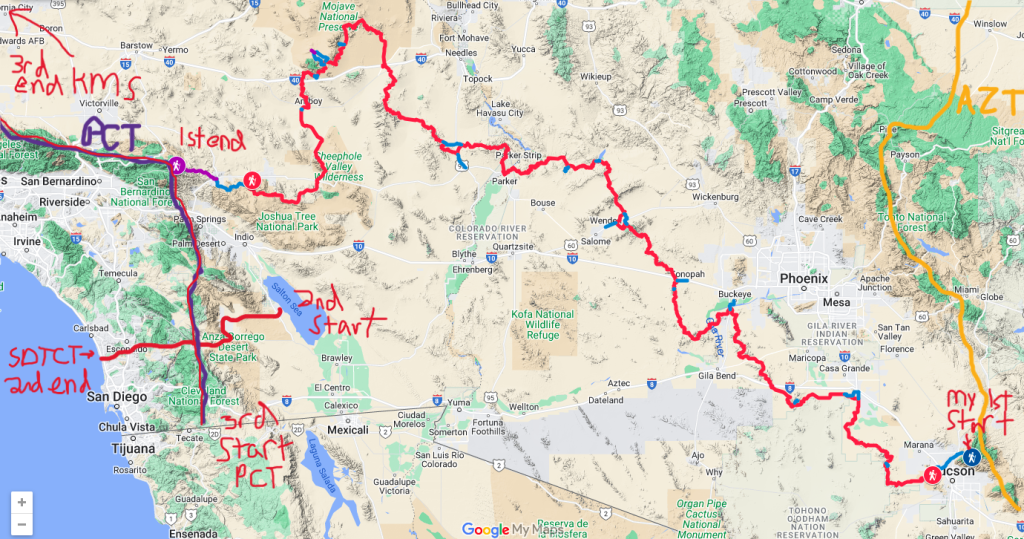
My 2nd objective was to complete another section of the PCT for a 2nd time. I began that goal back in 2023, when I hiked the NoCal section as part of my larger thru-hike from the Oregon Coast to the Sierra (the Pacific Coast Bigfoot Crest Rim Trail, PCBCRT). Originally, I intended to re-hike the entire PCT as a thru, but realizing that would now entail hiking NoCal for a 3rd time, I decided to just knock out the rest of the PCT in sections. So this was a great and easy opportunity to hike the desert. Plus, it was also in following with my desert theme for the start of the year.
My wait-and-see approach was to ensure that my focus stayed on the DWTH and that I didn’t put too much pressure on myself. It worked out just fine. By the time I was certain I’d finish the DWTH and the accompanying San Diego Trans County Trail, all the logistics for hiking the PCT section fell into place effortlessly. After all, I ended up in San Diego with my gear and perfectly-conditioned trail legs. I was feeling great and excited about the prospect of nearly doubling my mileage hiked on the DWTH. And I figured the PCT section would be a breeze after all the hardships I faced during my desert routes. The PCT had it all: well-maintained gloriously-graded trail, easy logistics, tons of town stops, heaps of trail angels, and all the hiker company I could want! It was such a contrast from my lonely and austere trek across the desert that I thought of it as my reward for making it through. And it was!
Since I’d previously written daily blogs for my 2018 SOBO PCT thru-hike, I decided to take a break from such a chore during this section hike. Yet I’m such a journaler and data nerd, I still kept track of details from each day. I also wanted to document the miles that connected my footsteps on the DWTH. So here are my notes that I took from each day, plus some pictures.
Day 1, Wednesday, March 26th, 2025, 1530-1900.
12.4 miles to stealth camp, before Hauser Creek, 1600’up\1390’down, elevation 3131.
Trail Angel Cynthia drove me plus 2 German friends, Thomas and Kai, to Campo in the morning. Arrived CLEEF around noon. I hung out there for a bit, meeting other hikers and eating delicious cake that Cynthia left us. Ditched my pack at CLEEF and slacked less than 1/2 mile up to border. There were several taking pictures and Stoke gave me a hang tag, such a nice guy. I got a ride back down the hill, grabbed my pack, said goodby to everyone, hit the trail around 1530. Trail so nice, I didn’t see anyone for the first 8 miles. Caught up to a bunch of people that started early in the day. I was leery of camping with a crowd so I kept going. Found an amazing small campsite in the manzanita trees just at sunset….perfect!


Day 2, Thursday, March 27th, 0700-1840.
26.5 miles plus 1.5 side trip to Cibetts Flat, then onto Morris Meadow, mm 38.8, 5450\2700, elevation 5900.
Wonderful peaceful sleep! 90 sleep score. Easy walk down to Hauser creek, passed about 4 going up other side. Talked to one guy for awhile. Recognized campsite from 2018 at about mm 18. Breakfast burrito in Lake Morena. Pretty easy walking rest of day. Went to Cibetts flats but Otzi was not there because he got kicked out for staying too long (even though he paid for the extended time and wasn’t causing any trouble/plenty empty sites)…wasted 1.5 mile side trip. Back on trail, climb and collected water from creek before camp in beautiful meadow, under ponderosa. But so damned windy! Camped alone again.


Day 3, Friday, March 28th, 0630-1710
17.5 miles to Oriflamme canyon, mm 56.2, 1760\2440, elevation 5200.
Lots of condensation and rain from overhead tree. Some stuff I used to block wind through vents got wet. Tent soaked. Very cold. Quiet morning walk through trees and mist. Warmed-up at tiny house place next to Pine Cafe. Good hikerbox. Nice owners and good Eggs Benedict for breakfast. First time I met Samwise and Goodwill. Lingered for a bit drying tent. Coke and hotpocket from general store. Started walking again at 1300. Wind horrendous. Tried 2 different pitches and had to revert back to first spot after several collapses, but at least I was able to keep tent standing. The overnight condensation would have been really bad. Cold night. Camped alone.
Day 4, Saturday, March 29th, 0630-1430.
21 miles To Scissors Crossing, Mm 77, 1600/4500, Elevation 2260′.
37 in morning but I did sleep well despite wind and cold. Walked fast in morning, cold, windy and misty but pretty sunrise over desert. Took small 1 mile detour along road to visit privy. Think someone was sleeping in one side of the double…hmm, sounds familiar. Got water at the tank where I camped on SDTCT. Talked to Dawn for awhile, solo hiker woman. Took break at noon to dry tent and snack. Was passed by a few hikers including Sam and Will. Caught them just before scissors crossing. 3 of us got quick hitch into town. Got rhubarb and strawberry pie from Moms, Whip cream and soda too! Finally, since I didn’t go into Julian on my SOBO…worth the wait! Grocery store lady gave me free granola bars, bought fried pickle chips. Two Feet adventures nice folks, bought new gaiters. Bee and Legend doing spaghetti dinner trail magic under bridge. Also 4 people from the Yellow Deli offering amazing ginger tea and yerba matte green drinks… heaven!


Day 5, Sunday, March 30th, 0830-1730
24.3 miles to Barrel Spring, Mm 101.3, 3250/2080 down. Elevation 3430′.
Giant pancake breakfast, tons of hikers, multiple trains of 5-10 people leaving in morning. Hiked past all, except for Sam and Will…so fast those 2! Short lunch at 3rd gate. Wind very strong, cold too. Last 3 miles hurt. Spring was packed with about 20 people. Ran into Tracy from CDT/Lordsburg 2019! Grabbed water and kept going across road just a little ways. Cow pasture quiet and decent protection from wind among bushes.


Day 6, Monday, March 31. 0630-0900
8 miles to Warner Springs, Mm 109.5, 750/1150, Elevation 3050′.
Drizzle in morning, tent wet but stayed dry and warm inside. Wind and rain in face walking across pastures. Eagle rock in fog, other hikers completely missed it. Walking along stream into town felt like hiking the AT. Dried out at the community center, what a great place! Texted TA to stay in room in town. Stayed with Tracy and Cliff, dogs Luna, Buddha, Roxy and Stella. Tracy made great vegan dinner.


Day 7, Tuesday, April 1st, 0900-1900
25.3 miles to Mm 134.8, 3960/3000. Elevation 4000′.
Lingered in town chatting with other hikers. Pretty nice walking all day. Through fields, oaks along Agua Caliente creek, then winding around hills and over pass, lots of pink boulders, little memory of section. Met family Antonio, Catherine and Rumey 5 yro kid so cute! Very cold by 5 pm. Walked extra to get another 600′ downhill. Pretty good site, 1 tent nearby but quiet.
Day 8, Wednesday, April 2nd, 0630-1300
19 miles To Paradise Valley Cafe, then Idylwild, Mm 151.8, 2800/1900. Elevation 4800′.
Miles included 1 mile side trip to Little Bear Hostel and 1 mile to PVC. Petted cute cat and dog at hostel but nobody else around. Very quiet, only passed 1 tent and then 1 guy all day. Sam got into PVC right after I scored a table, I ate a Gus Burger and she had a vegan burger that looked good. First, time at PVC, another place I didn’t stop when I was SOBO. Many hikers at PVC and in Idylwild. We got ride from Vic into town, didn’t even have to stick out thumbs, dropped off at PO, pitched tent in state park campground. Snowed a bit to cover tent. Walked around town in evening but everything closed early, just got some food from grocery. Going to be a cold night!


Day 9, Thursday, April 3rd, zero. 28 degrees when I woke. Packed and went to coffee shop Good Bean at 6:30 am. Met famous hikers Akuna and Mr Fabulous. Bought new Topo Ultraventure Pros at Nomad Ventures, on sale. Hitched to Whitewater with Canadian couple. Left food resupply with TA Kristin, picked up free microspikes from her. Sky picked me up from there, met partner, Arlen, nice reunion back at their AirBnB in Whitewater. In town for an art exhibit, perfect timing. Went to Palms Springs airport to pick up friend Ted, then grocery shopping, made amazing burritos for dinner, stayed in outbuilding, comfy bed, had my own place for the night!
Here’s also some of what I wrote on my Instagram: PCT days 7-9 Change is inevitable. Rehiking parts of the trail bring into focus how much things are the same and also so very different. Trail angels and hostels come and go. It’s also been a wonderful experience meeting the new hikers of this extraordinary trail. Some are very fresh… 5 years old like Rumey! What a trooper! And their exuberance is contagious. There’s also water and snow where there wasn’t in the Fall of 2018. And who knew there was a quail guzzler right along the PCT? I never would have recognized one before. These were the basis of water sources along the route I just did from Tucson…and all just as poor quality as the one here. Which is why I cached for myself. But here along the PCT, there are caches set out by Trail Angels like almost every 10 miles, which is pretty incredible when you think about it. Many hikers take this for granted or even expect it, but after 50 mile carries of 2 gallons on the DWTH, I am ever so grateful.
Day 10, Friday, April 4th, 1430-1830
10 miles to ridge, Mm 162, 2480/600. Elevation 6770′
Easy morning, shower, laundry, breakfast, Sky dropped me off in Banning. Ride with Michael, then Steven Idy Photographer, then sweet Helen from Idy to trail/PVC, She worked at library. While in Idy, woman drove up offering shower, everyone so nice in this town! Street tacos for $3 a piece at market, so delicious, best deal! Trail very quiet, passed 3 tents and caught up to one hiker is all. Climbed up ridge, very cold up there. Could see all the way back to Mexico and east to Granite Mountains and Edgar Peak in Providence mtns along DWTH. Also view of Eureka peak in JTNP, Palm Springs lights in valley, Salton Sea to the south. One of the best views the whole trip, but I paid the price overnight.


Day 11, Saturday, April 5th, 0530-1700
20 miles to before Strawberry junction, Mm 182.7, 5400/3800. Elevation 8383′.
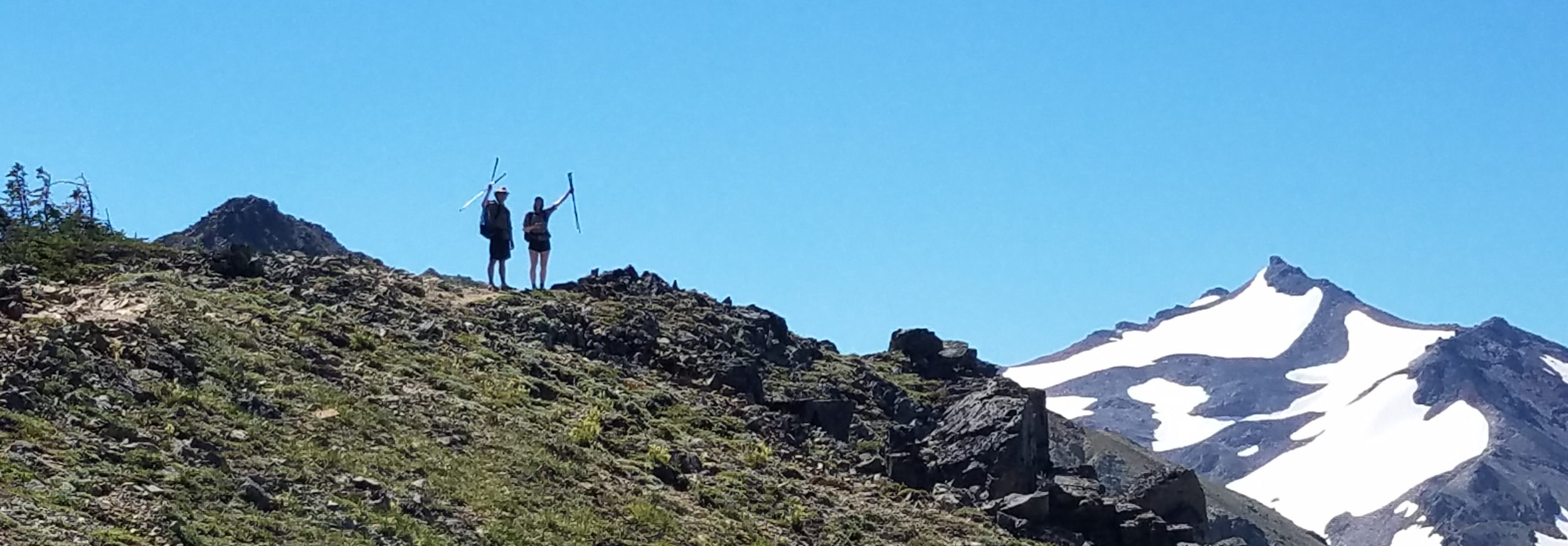
Wind ridiculous overnight, switched 180 to come from east and blasted tent. Covered in dust. Thought hair was tickling my face as I slept, but it was dirt raining down on me with every gust! Didn’t eat breakfast or make coffee, just packed quickly and got on trail. Wadded tent into ball. Nice sunrise, trees shedding ice shards onto my head in the wind. Passed a really nice protected site at the next campsite. Caught up one hiker but he was going down Spitler trail… that’s the one I hiked up to get back on the PCT in 2018. Hiked past a few sketchy snow spots (first was where the hiker died in 2020), then put microspikes on for a few easy spots. Started catching and passing other hikers that were struggling with blowdowns. Lots of climbing to get to the shoulder of Tahquitz peak. Then lots of snow on north facing side, couple steep places at the beginning but then just fun walking in snow and trees. I caught up to Sam and things got even more chill and more fun. We stopped to collect water at a spring and then took the lower valley alt to saddle junction. The trail became very easy and busy after that. We contemplated going up to San Jacinto peak but it was about 3.5 miles one way and already 3:30 pm so we decided to go straight to camp. Very awesome campsite, boulders and view to valley. Chaz and Louise showed up and we had fun time hanging out watching the sunset. The day started off rough but ended quite awesome!


Day 12, Sunday, April 6th 0700-1800
17 miles to W. Fork Snow creek, Mm 194, 3360/5400 down. Elevation 6353′.
Miles included up and back to San Jacinto, about 6 bonus for side trip! Wind got strong again overnight, lots of flapping waking me up even after earplugs and Benadryl. Took it slow packing to align with Sam for hike to top of San Jacinto. All snow, but easy grade and good traction with spikes. Met Jon who does trail reports! Wish we got pictures with him. Hut was cool, bunks and log book. Such amazing views. Peakfinder said I could see Planet peak, Harcuvar mtn and Harquahala, but at nearly 200 miles away, too hazy. But could see JTNP, Pinto mtns, Sheep Holes, Granite and Providence mountains…nearly half the DWTH. We were only ones at top for about 20 minutes. Had lunch when we got back to our packs. Slow going down Fuller ridge. Lots of snow for 5 miles until mm190. Hiked with French Canadian 7Up, who gave me an orange. Sam’s leg hurting, she stopped at upper campsite with Galloping, sister and husband that’s Chiropractor…trail provides! Camped near stream and Coulter Pine, also very nice manzanitas and ponderosa. Very windy above, but well protected in trees, no one else around.
Instagram Post: PCT Days 10-12 I finally hiked the whole PCT! In 2018, I had to miss about 10 miles from Saddle Junction to Spitler peak, along the ridge near Mt San Jacinto. There was a fire closure in that area for about 5 years. It finally reopened the next year and I vowed to someday go back to finish the section. It’s actually a pretty difficult stretch due to lingering snow patches and steep, sketchy ledges everywhere. No wonder it took trail crews so long to rebuild the trail. It required a lot of engineering.
Before tackling this section, I hitched down to Whitewater to meet up with my hayduketrail friend Sky (who also thru-hiked the PCT). Sky and friends had an Airbnb for the weekend, as they were going to an art exhibit in Palm Springs. It worked out perfectly, as I was able to drop a resupply box at a trail angel’s house and found a free pair of microspikes that were just enough to keep me from dying. In fact, I felt confident enough to hike all the way to the top of San Jacnito, 10,834′, which I didn’t do on my SOBO hike. We hiked halfway down the same day… it’s a crazy descent. Last time I had to go up it, with no water along the way, so grateful to be going down this time.


Day 13, Monday. April 7th, 0730-1930
26 miles, W. Fork Snow creek to Whitewater Preserve, Mm 218.6, 2620/6900. Elevation 2200′.
Great night sleep, no wind and dry in morning. Long walk down to I-10. Passed the 200 mile mark. Easy at first, then overgrown and a little rocky. Then easy again. Started getting warm. Talked to mom, learned my Uncle Berry died. Flicked garter snake into feet. Rinsed/got clothes wet with a bottle at spigot. Passed 3 different couples. Then another few guys. Walk across valley, very hot, 85, umbrella up. So much like the DWTH. Grabbed 3 sodas and orange at I-10 bridge then went to TA Kristin’s to get resupply. Took my time there. Louise and Sam, Sweeping Beauty. Finally left at 4 pm, doused using hose, dried in 20 minutes. Beautiful hike in late afternoon. Desert so green. Trail very cool in and out of valleys, so different from what I recalled. Took Canyon View loop trail to Whitewater preserve. Incredible place to camp in grass lawn near ponds. Took quick half dip in pool in dark. Ate dinner by pool listening to frogs….so spectacular. Orion and 3\4 moon. I love this place, 2018 camp was just as magical. All night could hear rockfall from canyon wall nearby…think the desert bighorn were taking aim at us campers down below. Finally connected footsteps Tucson to San Diego!


