


Summary of my 2026 spring AZT hike: I kept notes but didn’t post daily blogs, since I previously did so for my 2019 AZT thru-hike. Of note, I didn’t hike all of the AZT this second time around, but I did cover about 650 miles of it. From the start, I had no intention of doing the full trail, since there were a few parts that I’d hiked twice already, given the overlaps with my Grand Enchantment and Mogollon Rim trail hikes. Additionally, the North Rim of the Grand Canyon was still closed due to the Dragon Bravo fire, so I instead finished my hike at the Colorado River, then spent some time exploring more of this most incredible National Park. My overall goals were to simply spend some “easy” time enjoying the desert in the spring, as opposed to my fall-season AZT hike and more strenuous Desert Winter Thru-hike (Tucson-San Diego/AZT-PCT) the year prior. I also wanted to see the new sections of trail that had been added since 2019, eliminating road walks around Patagonia and improving some of the routing elsewhere.
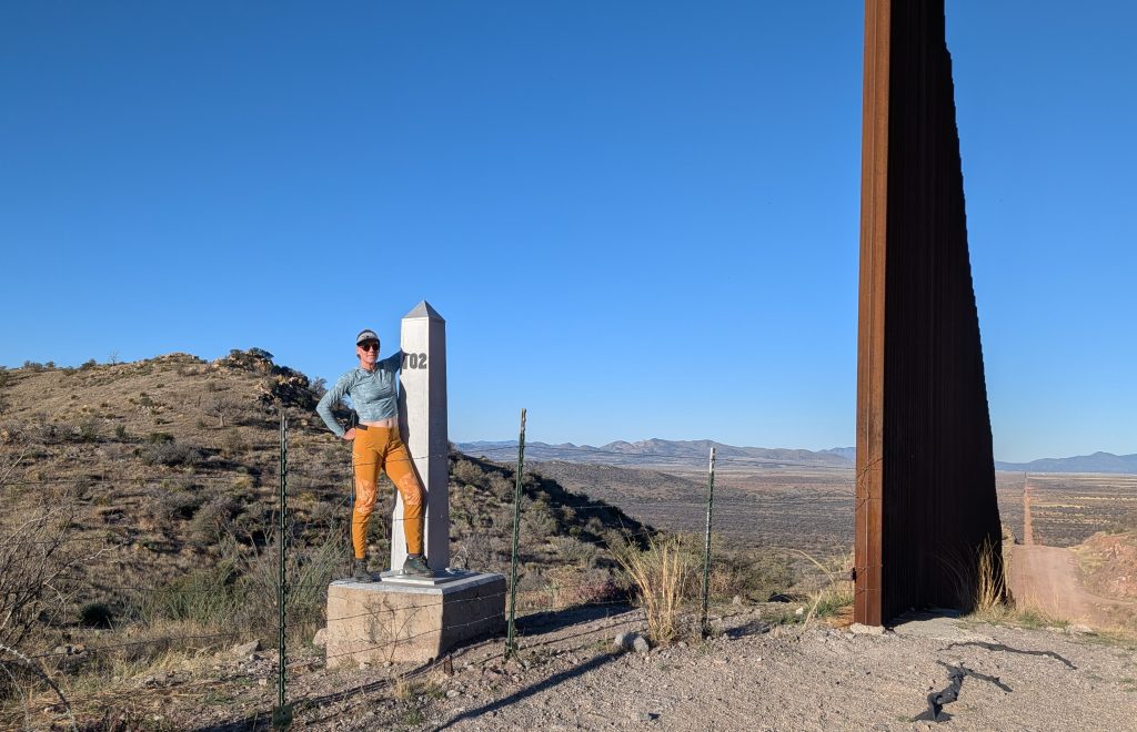
Sadly, this was probably the last chance I and anyone else had to visit the AZT border monument. Only weeks after I was there, the current dictatorship resumed construction of the border wall, mostly likely permanently denying access to hikers. The short, pointless segment of wall and road (pictured below) was added only months after my first visit (photo of what it looked like before when it was just wilderness). That construction phase quickly ended due to the 2020 pandemic and then regime change, err, I mean election. But alas, corruption and boondoggles of such massive scale always seem to find a way to rear their ugly heads once again. Entonces….
It was March 20th (an average AZT NOBO start date) when I set off from the Mexico Border, in the midst of the earliest extreme heat warning for southern Arizona on record (beating the previous warning by over a month). And here I thought this hike was going to be easy! The first week brought daily temperatures in the high 90’s and 100’s. During this time, I had to adapt my hiking schedule to begin at 5 am or earlier, take 4 hour lunch breaks during the peak afternoon hours, then hike until an hour or more after sunset. But I still managed to get the miles done and not suffer too badly from heat or dehydration…in fact I managed this much better than on my first AZT hike. Of course, I relied heavily on my trusty umbrella, which I wholeheartedly credit the success of all my desert hikes to. By this point, I consider myself to be a very seasoned desert traveler, perhaps even an expert???


The conditions were pretty hot and dry all the way to Pine, not unlike the conditions I experienced in the fall. There was only a little bit more water this spring, compared to my fall hike, but it did make enough of a difference. I also benefited from several water collectors that the AZTA installed since 2019. Yet there were still some long water carries…nothing I’m not used to by now. In fact, a 30 mile carry feels like nothing since I did a 50 mile carry for the Desert Winter Thru hike.


Ironically, the day I arrived on top the Mogollon Rim, nearly a month later, I abruptly was contending with a dusting of snow and below freezing temps. That’s how it goes on the AZT. Arizona is all about extremes! But I much preferred the cooler conditions to the extreme heat that I started in. I reached the Big Ditch and Colorado River on April 22nd, celebrating the end of my hike in one of the most stunning settings in all the world. I didn’t miss hiking the rest of the way to the Utah border in the least. In fact, I think the Grand Canyon is a much better and more appropriate location to end the AZT than some arbitrary and imaginary border, but that’s for another discussion. I spent 2 bonus days hiking the Hermit-Boucher trail loop, then backtracked to Flagstaff, then Phoenix for a flight home.


Here are some of my 2026 AZT stats:
Dates: March 20-April 24th
Miles: 646
Days: 36
Zero days: 4 (Superior, Pine, Phoenix, Flagstaff)
Average daily mileage (including zeros): 18 mi/day
Average daily mileage (excluding zeros): 20 mi/day
Most miles hiked in one day: 32
Days hiked 30-32mi: 4
Days hiked 25-29mi: 5
Days hiked 20-24mi: 11
Days hiked 10-19mi: 9
Days hiked < 10mi: 7
High Point: Mt Lemmon 9,100″
Low Point: Gila River 1700′
Peak Bagging: Mt Mica and Spud Rock, Mt Lemmon, and Picket Post.
Biggest elevation gain / loss in one day: There were a couple days where I gained around 7,000′ (leaving Roosevelt Marina, hiking out of the GC via Boucher Trail) and a day where I lost close to 7K’ (coming out of the Mazatzals)


Nights I slept in my tent: 25
Nights camping alone or with only 1 other: 19
Nights camping in the same location as 2019: 1 South Rim GC Mather campground hike-in.
Nights spent camping for low cost or free at a campground/park/hostel: 6 (Patagonia, Saguaro NP, Roosevelt Lake, Grand Canyon NP)
Nights hosted by Trail Angels and friends (including before and after trail; Vail, Kearny, Superior, Phoenix, Pine, Flagstaff): 15
Nights spent in a hotel or Air B&B: 0
Trail Town & Resupply Stats:
Trail Towns/Resupply Stops: 11…Patagonia, Vail, Summerhaven on Mt Lemmon, Kearny, Superior, Roosevelt Marina, Jon’s house outside Phoenix, Pine, Flagstaff, Tusayan, Grand Canyon South Rim.


Rides: 2 paid shuttles to border and Patagonia hostel to Th. 2 ubers, to Josh’s house and Safeway to trailhead Vail. Rides to/from trail/airports/around towns from Josh, Jeff, MJ, hiker grandparents, Jon, Nate, Michelle, Robin, Kim. 3 hitches (into Patagonia, Oracle to Kearny and South Rim to Flagstaff).
Resupply boxes sent: only 1 from Vail to Kearny, bouncing some extra food since I had no appetite due to the heat the first week.
Most days between showering/laundry: 4
Longest gap between resupplies: 4 days
Sections missed or altered: Skipped 16 miles around Vail (Sahaurita to Pistol Hill), skipped 56 miles from Oracle to Kearny, skipped about 5 miles just after HWY 87, walked powerline road on Mogollon Rim, lots of alts north of Flagstaff walking dirt roads. Did not hike last 80 miles or so from Colorado River to Utah border due to fire closure and pain in the ass logistics.
National Parks: Coronado National Monument, Saguaro National Park, Grand Canyon NP.
Campfires made: 0
Days of precipitation: 2 (1 was overnight snow/sleet/rain)
High/low: 103/26 degrees F
Longest water carry: a couple around 25 miles to avoid earthen water tanks or the Gila river. There are some long stretches north and south of Flagstaff if you are like me and avoid brown water.


Animals sighted/heard: Elk, antelope, mule deer, white-tailed deer, cows, horses, coyote, javalina, coati, Goulds Turkey, pyrrhuloxia cardinal, Scotts oriel, vermilion flycatcher, couple kinds of hummingbird at center in Patagonia, canyon wren, cactus wren, road runner, elf owl, western screech, GHO, poor will, ravens, red tailed hawks, blue grey knatcatchers. desert tortoise, 3 black rattlesnakes, 1 diamondback, gopher snakes, king snake, Desert Striped Whipsnake, horned lizards.
Times I Wished I Carried a Gun (or Knife or Bear Spray): 0


Hikers, Trail Angels, and Trail Magic: I’m incredibly grateful to all the Trail Angels and friends I met and that helped me along the way. Even though I hiked solo most of the time, which made this trail experience feel kind of lonely, I did enjoy a lot of (too brief!) encounters with some awesome people. I even met a couple, Chickpea and Joker, all the way from Belgium who recognized me from my blog…I was most surprised by this! If you’re still reading, hi guys, it was so great to meet you!
Former hiking buddies, alumni and acquaintances met on or near trail: Blisterfree and Treehugger @hikeinvention (Gurus of so many of my previous hikes–GET, MRT, DWTH), Jiyuu (PCT25), Greg in Wild (AT21), Skittles (PCT25), Bamboo (PNT22), Mary and Kelly (PNT22), Darwin @EvolvedSupplyCo (PCT18), and Nate Good Katz (2024) @Aardwolf Gear Co. Nate made me a new tent and stake bag while I was in Flagstaff, which I need to get around to posting about on social media…one of these days.


Trail Angels: The AZT just might have the best trail angels of any trail I’ve ever hiked! It certainly has the biggest collection that I’ve been a repeat customer of. Here’s the abbreviated list: Josh (my 3rd trail visit to my Florence High School class buddy!), Gabrielle (very affordable shuttle to border and fuel canister), Jeff and Que (hosted me for one night and have supported thousands of other hikers/donate all money to the AZTA and veterans programs), MJ (my 3rd visit…she is a legend and the GOAT TA), Jon (my #1 TA and at least my 7th visit to his home), Robin and Marty (1st time TA’s that graciously hosted me and Bamboo for 2 nights, lovely people), Michelle and Doug (founder of the Camel-up water collection device …you’ll hear more about this from me, and phenomenal TA’ s who hosted me in Flagstaff), Robin and Kaden (relatives of my best friend from college and genuinely great people who also hosted me in Flagstaff), Kim (gave me a ride all the way from Flagstaff to Phoenix and also helps hikers get from Sierra Vista to the terminus) and lastly, Mary Walker (again my 3rd or 4th visit! plus got to camp with her and Kelly on trail and got to see Boon! my favorite trail pup). Thanks to all and sorry to those I might have accidentally missed. Your support, generosity and friendship are most appreciated!


Lastly, I had perhaps my most interesting hitch of all time, thanks to a gentleman from Mammoth named Larry. In the same sentence, he mentioned being a CIA agent and a convicted felon. I don’t know if the 2 were related. I wish I would have recorded the whole conversation we had. He drove me all the way from outside Oracle to Kearny. His was the first ride I nearly turned down, due to the rough appearance of his car. And believe me, I’ve gotten rides in some rough looking cars over the years! But I figured since he was older, I could at least outrun him if needed. He turned out to be mostly harmless, even after trying to convince me to go gambling with him at the nearby casino. I’ll never forget that ride.
Trail Magic: In addition to all the magic the trail angels provided, I was lucky to hit Patagonia during their annual chili cook-off! For $5, we hikers got to join the locals in sampling and voting on 12 different kinds of chili and 4 kinds of cornbread. There was live music and lots of beer, plus a magical sunset and amazing local vibe. I enjoyed hanging out with the largest collection of hikers I saw on trail: Doda, Cardinal, Sunrise, 8ball, Bearclaw, Slimer, Scooter, and several others that I neglected to write down names for. It was such a great time. Then in Pine, I was invited to the Men’s Prayer Breakfast at the local baptist church, thanks to Robin, Bamboo and Pastor Todd. It turns out, women are invited too but have to show up with an appetite as big as the men, and I had no problem meeting that criteria.


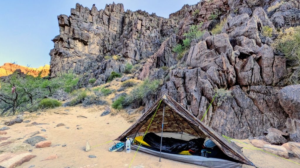
Gear: I brought my Zpacks camo plexamid tent, HMG Waypoint pack, 30 degree Katabatic Gear Palisade quilt and women’s neoair Xlite thermarest, along with all my other little stuff that I’ve been carrying for years, yawn. I did experiment a little, though. Instead of bringing a puffy, I carried my 50 degree EE Apex (synthetic) quilt to use as a stand-alone or top quilt and to fashion as a cape if it got cold enough in camp. Well, it didn’t work all that great as a cape, so I was lucky that Kelly lent me her down vest to use for the last week and half. Thanks Kelly, you saved my butt! I was also really glad I had my extra quilt to double up as needed during the end. As always, my umbrella was invaluable in getting me through the initial heat wave. I used it nearly daily up to Pine, then I don’t think I even used it once after that.
This was my first long hike wearing a sun hoodie. The idea of a hood as opposed to a hat always seemed hot and claustrophobic to me. But I have to admit, I really liked the experience of a sun hoodie! I was very particular in selecting one and I think I got lucky in finding one that worked for me. I went with a Mountain Hardwear Crater Lake Crop zip hoodie, after reading that reviewers found it to be thin and also cooling when wet. I found this to be the case, plus really liked the crop-top fit and zipper (more air flow). The sleeves were nice and long with thumb holes (but I still wore sun gloves) and the hood was roomy and stretchy enough to pull over my visor, creating a pretty solid hide-away for my face. I also have to admit that going NOBO was preferable to SOBO when it came to the sun being in my face. I always thought this was the lamest excuse, but there is some truth to it. On the other hand, my calves did get a bit sunburned in the first week.
And on that note, another new experience for me was wearing PANTS! Yes, as you can see from the many pictures, I wore my obnoxious yellow and flower print Patagonia pants. Their official title is the Patagonia Dirt Craft pants (golden caramel), which I found on deep discount at a outlet store in Reno the previous fall. They were meant to be mountain biking pants but are the first pair of hiking pants that I’ve ever enjoyed wearing. They are lightweight, thin, stretchy, fitted at the ankles so they don’t swish, and even have panels with air vents! I still brought my Purple Rain hiking skirt and wore it about half the time. But it was nice to be able to switch in order to keep the sun off my legs and also for when it got cold. I plan to bring the combo on future hikes.
As for the matching jacket, well I found that in MJ’s hiker box and just had to switch out my old rain jacket for this new one. It’s an OR Helium…together with the pants, I’m quite a sight. It cracks me up that half the time I look like I purposefully matched my clothing and shoes and the other half the time, I clash horrendously. That’s what you get with a strategy of free hikerbox stuff and sale/outlet items. I assure you, color is usually my last consideration when it comes to gear and clothing.
Pairs of shoes: 2. For the first 385 miles to Pine, I wore a used pair of Topo Ultra Venture pros that already had about 500 miles on them from the PCT the year before. Then I switched to a pair of used Salomon Speed Cross 6 that had around 400 miles from the Sierra High Route and other travels. I wore those 260 miles to the end (and am still wearing them for the first 100 miles to start the International Appalachian Trail).
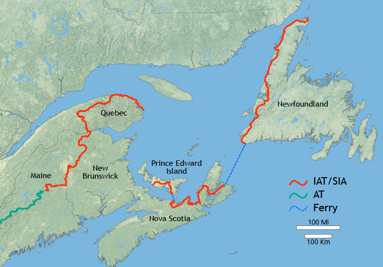
Well that’s about it! Stay tuned for (hopefully) a trip report about my Grand Canyon Hermit-Boucher loop hike, plus an announcement of my summer plans: The International AT through the rest of Maine and a big chunk of Canada.