Friday, March 21st, 2025, 0700-1840
PCT water tank to near Cedar Creek Falls trailhead mm101.5, Elevation 2000′
26 miles.
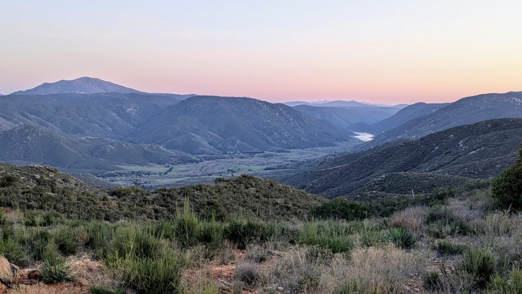
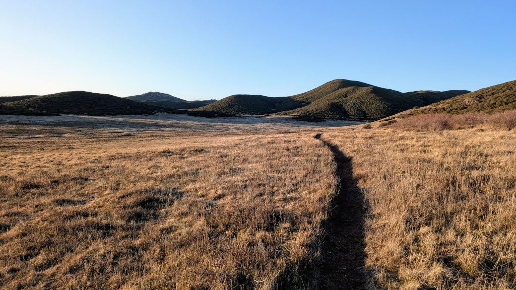
It was very cold in the morning, just 37 degrees F! I actually passed frost on the grass as I set out. I was sad to find that the route didn’t spend any time following the PCT. I merely crossed it and continued following signs for the California Riding and Hiking Trail. I even saw another sign for the SDTCT, complete with a little map! This was just as well, because the route led through a series of beautiful meadows. The meadowlarks and blackthroated sparrows were singing gleefully, while a family of ravens tumbled around in the grass. It was so gorgeous in the morning.


I crossed HWY S1, the road that led to Mt. Laguna, and continued to wind through meadows on the way to Lake Cuyamaka. From this point, I knew what to expect because I’d driven past the lake with Otzi. The route wrapped along the south side of the lake, sometimes following a trail and sometimes going cross-country. I had to pass through some pretty soggy areas and just barely managed to keep my feet dry by stepping on the tops of the tussock mats.
I picked up a nice trail that wound through Cuyamaca Rancho State park and took some time to check out the small mining museum, inside a historic cabin. It would have made for a nice shelter, but I imagine they locked it at night. There were supposedly cameras all around, too. The mine was fenced off (unlike the hundreds I passed by in the desert), but there were many information displays to read and learn all I needed to know of the area. The gold rush, all the rich men that came to exploit the area, the inevitable bust, mining towns abandoned, then reinvented into tourist attractions (Julian), etc. etc. The weather was so beautiful this morning, I just really enjoyed taking my time through the park. One of the coolest things I saw was a Jeffrey Pine Cache tree. Acorn woodpeckers drill holes to store their acorns, and they’d really gone to town on this particular tree! I couldn’t believe how many acorns they’d managed to stuff into the bark! There were thousands cached in this and a neighboring pine. There seemed to be a lifetime of acorns to last the woodpeckers. I guess they were having their own little gold rush moment.


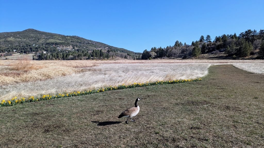
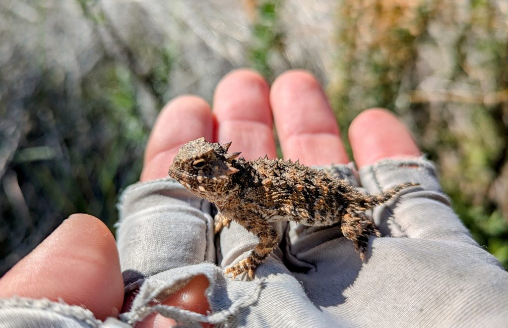
As I left the park, I saw tons of people coming across the dam, apparently participating in a running race. I could have crossed the dam to take a short-cut, but didn’t want to get in the way of the runners, so I just stuck to the route. It led past a very low and soggy path across a creek. Again, I just barely managed to keep my feet dry. On the upside, I got to harass some Canada geese. They were all around the lake, but I didn’t manage to find any bold enough that I could get my hands on. So no goose pettings for me (I have a history and obsession with this).
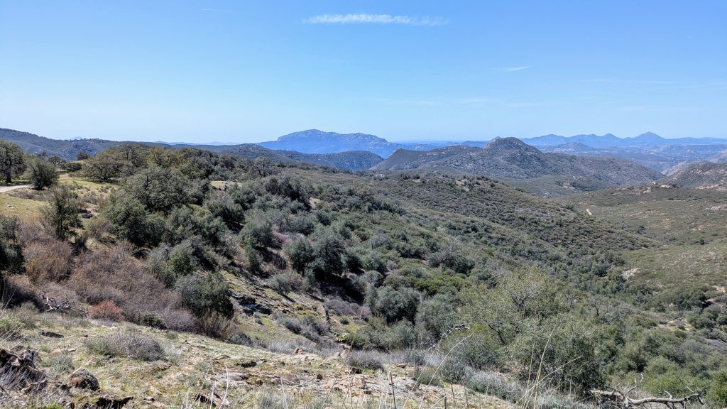
I arrived at the nearby cafe around 9 am, which was way too early for the opening at 11 am. So I used the public restroom and kept going. Lake Cuyamaca was the highpoint of the route, so the rest of the day was spent dropping down towards the coast. First the route went along an obscure old road called the Kelly Ditch Trail. It hadn’t been maintained in a very long time and involved some light bushwhacking. It reminded me of the overgrown, old logging roads that made up a big part of the PNT. But there were a few nice views looking west, where I imagined I could even see as far as the ocean. El Cajon stood prominently and still seemed very far away. It was on the agenda for the next day, while this day promised to be mostly pretty easy, save for the current bushwhack.
After about a mile, I joined paved Engineers road (which I could have walked all the way from the lake). It was very curvy and narrow, but thankfully relatively free of cars. Only a few passed in the several miles I walked down it. It made some huge switchbacks down the mountain and I marveled at all the fancy cabins and giant houses along the way. Apparently the whole area burned in 2006 and had since been replaced with many more new and expensive residences. No doubt the fires would threaten again some day. But this day it certainly seemed like a sweet place to live. The weather was beautiful, the daffodils were blooming, and I didn’t have a care in the world.
I had lunch next to Sandy creek at the bottom of the hill. The road switched to dirt (Boulder Creek rd) and I followed it through an undeveloped area that was mostly ranch land, with sporadic giant oak trees. What a beautiful trek through this area! It was so peaceful and bucolic, it was hard to imagine that I was so close to a major coastal city. I talked to the cows and waved at a few trucks driving by, one of which was Forest Service. It was good to see that our government was still employing a few of them…who was going to protect all these million dollar homes from the fires, after all?
After an hour or so, I came to a developed trailhead for Three Sisters Falls / Eagle Peak and almost mistakenly took that trail. There was a large parking lot, a nice privy, trash cans, and information boards…all of which drew me in. A number of day hikers were utilizing the area, which was nice to see. After rechecking my map, I hopped onto a lesser dirt road that descended into the Kelly creek watershed. The road was closed to regular traffic but it was still an easy stroll. Where the road crossed Cedar Creek, I decided I just couldn’t pass up the opportunity for a cold plunge. Had I been able to go for a dip even once this entire desert hike? Not since the Bill Williams River, I guess. It had been a hot minute. And speaking of hot, it was and so was I, so the dip was incredibly refreshing. Ahh, to have the luxury of running water once again!
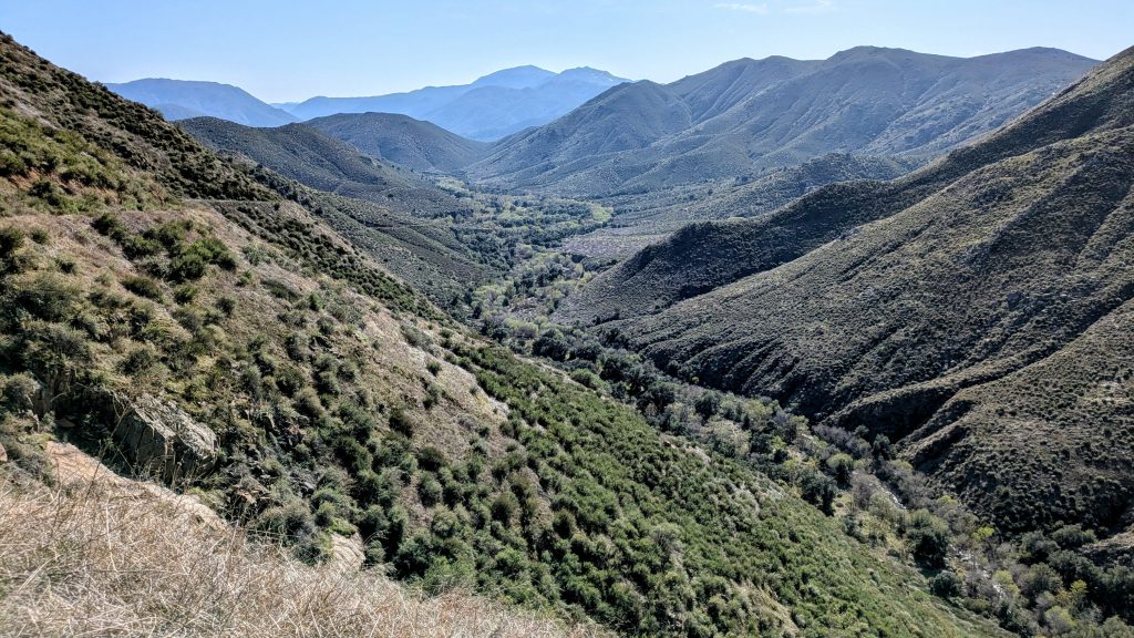
The road climbed for a bit, so my cold soak timing was perfect. Then I followed a very washed-out truck road down into the San Diego river watershed, relishing in the beautiful views of the wide and dramatic valley. The road traversed the steep hills masterfully, and was yet another highlight of this route. It was such a cool trail, I’m surprised I didn’t see a single other person on it.
At the bottom, I intersected the very popular trail to Cedar Creek Falls. It was so popular that a permit was needed to go all the way to the falls. Of course I didn’t have one, but was very tempted to take the side trip anyway, especially since it was pretty late in the day and I didn’t think anyone would be there checking. But I opted to play by the rules. At this point, I needed to also find a campsite, pretty soon. It would have been very easy to camp along the San Diego river but there were still a few hours of daylight left and I felt like pressing on. I wanted to get as early of a crack at the climb up El Cajon the next day, so nailing a few more miles seemed smart. Only problem was, there was a big climb out of the valley. So I took another dunk in the river, which was all the refresher I needed.
The popular trail was well-graded, wide, and so easy. I flew up it, past all the straggling day hikers, who must have wondered why I was hiking so fast and with a backpack. At the trailhead, I saw where rangers were normally stationed to check permits, but had already packed up for the day (I’m pretty certain I could have visited the falls, no problem). There were all the standard developed trailhead amenities, even a water spigot and picnic tables. I decided to make my dinner there, enjoying such luxuries. Then as the sun was just beginning to set, I carried on, hoping a stealth site would magically appear. I normally have a high degree of confidence in finding one, and sure enough, within half an hour, I nailed the perfect spot.
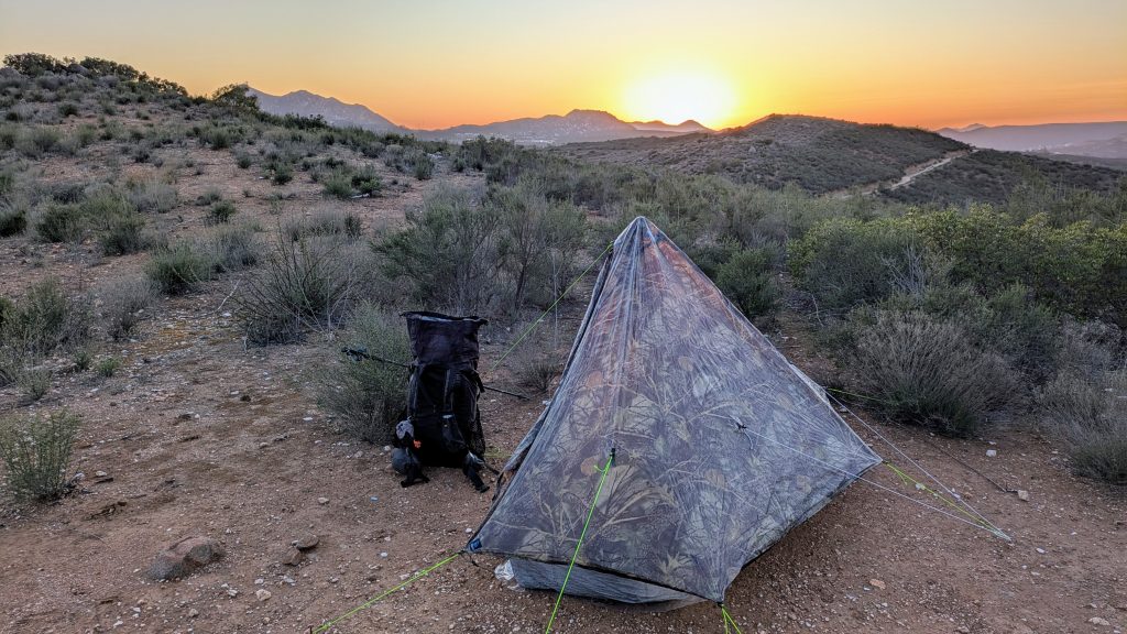
Lucky for me, it was calm this night, because the ridge was extremely exposed. But man, what a view! I could see nearby El Capitan lake, El Cajon, and the shimmering lights of the distant housing developments. I was in close enough proximity to society to hear barking dogs, but I still felt a world away. While my site was probably not technically legal for camping, I certainly wasn’t bothering anyone and was basically out of sight, not that I figured anyone would be passing by the old truck road at night. I was blown away by all the beauty and diversity of this day, on quite the high from such a fun thru-hike. But I faced a monstrous section the next day, full of tough decisions about private property issues and bushwhacks from hell. Thank goodness this day ended on such a high note, easing my worries.