Thursday, August 18th, 2022, 0750-1830
Whitney junction HWY 20 to Dike rd on Whidbey Island, WEBO mm 990, Section 8 Puget Sound
28 miles, Gain 3060′, Loss 3030′, elevation 20′
It ended up being a very early morning. Alarm clocks went off at 02:30 am as the Germans and Wolverine woke up and prepped for a 60 mile hike. They’d hatched the idea a few days before, wanting to set a new personal best through a road section that would allow for it. They were pretty quiet and I tried to sleep through the rustling but came up short. After a bit, I gave up and just read some stuff on my phone. They were off shortly after 3 am, when it grew quiet once again…until some snoring started up. I drifted in and out until my alarm went off. I’d be dragging from lack of sleep later in the day but was able to get ready and share in the making of some coffee and breakfast…eggs and crab. Delish!
Marc came over bright and early as planned, graciously to give us a ride back to where we’d made it the day before. During the ride, I learned that he’d worked on one of the famous “A” boats out of Anacortes (called so because they all had name’s beginning with an A and were also the Cadillac’s of the fishing fleet). Long ago, I’d read a book detailing one of the worst maritime tragedies in recent history, called Lost at Sea, by Patrick Dillon. It was about 2 of the “A” boats that had capsized shortly after leaving Dutch Harbor for a crabbing trip. All 14 crew members had died…and as I just learned, one of them was Marc’s cousin, age 24. His name was Lark Breckenridge and in one of the newspapers, they’d accidentally printed his name as Mark…for several days many of Marc’s friends and relatives thought he was dead. What a crazy and sad story! It hit me really personally since I’d read the book and worked on fishing vessels as an observer. I’d known others that had died in the industry. Really sad.
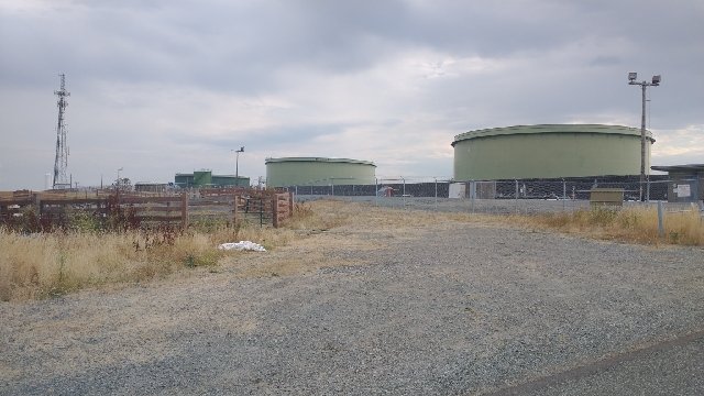
Marc dropped Quetzal and me off at HWY 20, resuming our steps from the previous day. It wasn’t too bad of a stretch, despite several lanes of traffic in each direction. There was a wide shoulder at least. I crossed a big bridge on a sidewalk behind a guard rail, looking down at the casino along the bay. I turned right onto a road that led around the March Point peninsula. This was a weird quasi industrial and farm area. There were huge oil refineries with tanks all along the hills and trucks coming to and fro to pick up the goods. And yet there were cattle grazing amongst the fray. As interesting of a backdrop as this was, I wasn’t too into it. Rather than go all the way around the peninsula, as the red route outlined, I took a shortcut across on North Texas road…perhaps this is what north Texas also looks like? It cut off about 3 miles of road walking around the refinery…no big loss to my trail experience, I figured. The shortcut was also very quiet, bringing me high with some views to Anacortes. I passed huge tanks and noticed a lot of security cameras, security trucks and prison-like fencing. They were protecting some valuable and sensitive stuff in there.
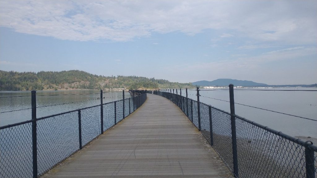
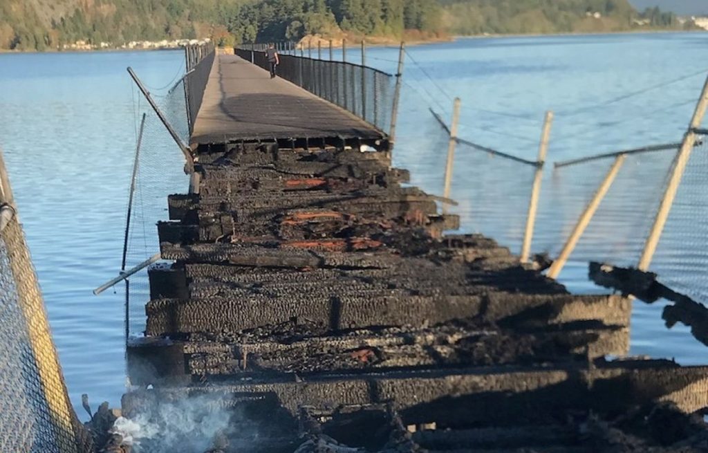
I connected to a long footbridge across Fidalgo Bay (the Tommy Thompson Trail), commencing a nice rail trail pedestrian pathway along the shoreline, that led directly into Anacortes. (I would learn that this bridge was nefariously set on fire and closed to PNT hikers only weeks later…so sad). There were lots of nice information displays describing the history of the area, restoration efforts, and the natural marine environment. It was nice to be in the company of many walkers, joggers and cyclists out enjoying a beautiful morning. One woman asked if I was training and it reminded me of the same questions I’d gotten when hiking through Auckland. No, this was a part of my 1200 mile journey to the ocean, I explained, while she just looked at me confused. People must think I’m crazy.
I walked up a street to the main thoroughfare leading to downtown. I didn’t feel a need to sight-see in Anacortes, so I made a brief pit stop to fill my water bottle and buy some pastries at a coffee shop. A cream and passion fruit danish caught my eye, along with a peach scone. I inhaled the danish, as it was maybe the best pastry I’d ever had, second maybe only to a fresh-baked scone with homemade cream I stumbled upon in New Zealand. I almost went back for a second, if only I hadn’t already walked 2 blocks. The scone was good but paled in comparison to the danish.
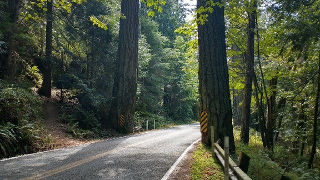
I passed through the lovely neighborhoods full of bright and varied styles of houses. The hills to the west had been preserved as a green space, with a network of community trails. Here I resumed nice soft trails through lush forest for the remainder of the morning and much of the afternoon. Seriously, there was so much trail, which was contrary to my expectations of this area. Yes the trails were a bit convoluted, not always marked, intersecting many times. I had to check my GPS and maps a lot. But it was a very pleasant experience overall. I passed many little lakes and hardly any people.
I saw one man with a backpack taking a break, but didn’t stop to talk to him. Karaoke later mentioned meeting him, relaying that he was an eastbound PNT section hiker who came across as pretty disgruntled. Unsolicited, he’d predicted that she was going to have a very hard, if not impossible, time hiking the beach\coast section when she came to it. Something to the effect that she wouldn’t be able to haul herself up the ropes? We weren’t sure how completing nearly a thousand miles of difficult trail, bushwhacks and blowdowns didn’t translate into being able to handle the beach walk but ok (spoiler alert: it was relatively easy compared to many other parts, though I did have favorable tides). I wished I’d talked to him, because I would’ve had a fun time dashing any negative sentiments about my abilities. I didn’t make it through 14k miles in 5 years without being tested a bit…both by the trails and the fear-mongers.
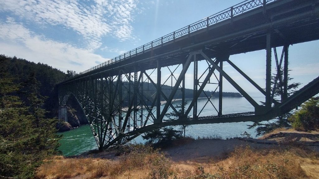
I came to a road crossing just before Deception Pass, where an obscure trail continued down and parallel to the road. Here again I’d read that previous hikers had walked on HWY 20, narrowly avoiding being hit by passing cars. I guess they’d missed the notes describing how to find the trail or had chosen to stay on the busy road, which is a shame because the trail was great. No need to risk my life…as I’d found to be the case with much of the Puget Sound section. The trail popped up to the sidewalk along the bridge, where I met an abundance of tourists. The lanes on the bridge were exceedingly narrow, as was the sidewalk. I had a hard time squeezing past with my pack, without knocking someone over the side into the traffic or the long drop to the ocean (there were walls and guardrails, of course). Views down through the tight channel were pretty unique…I could see why it’s quite the draw around the area. The bridge was built in the 1920s and was a very difficult project back then. It connected Whidbey Island, the largest island in Washington State, to the rest of the upper Puget Sound. I’d driven through the island way back in 1998, while visiting Seattle for the first time. This was the first I’d been back, nearly a quarter of a century later. I would’ve never guessed I’d be walking the length of the island on my return.
I took a late lunch break at the south side of the bridge, finding water from the sinks in the bathrooms. It can sometimes be kind of hard to find decent drinking water while ‘urban’ hiking. My break was short, as I knew I needed to press on. There was no way I could make it 20 more miles to get to the trail angel’s house but he’d agreed to come pick me up wherever I made it. Still, I wanted to lessen the distance that he had to drive. I took a series of trails through the state park, winding in and out of coves. Then it was finally back to a quiet road, which turned in a pleasant road closed to vehicles along the coast. At Hoypus point, this road abruptly ended and I checked my maps to see that I’d missed a turn onto E Hoypus Point trail, leading up and over the point. No problem, it was low tide and notes assured me I could just walk the beach all the way to a spit. Well, turns out beach walking in WA involves clambering over more blow-downs and driftwood…most with sharp barnacles growing all over them. There’s also stretches of rocks to contend with. I promptly scratched my knee and blood ran down my leg. It was certainly a far cry from the beach walking I was used to in Florida and probably added an hour and some extra distance to my already long day. Still, I had a fun time. I saw lots of bald eagles and herons, along with a few boats.
Presently I made it to the spit and back to more quiet country roads, bumbling along until I deemed it time for a pick-up. I certainly could have taken a more direct route along HWY 20, avoiding all the beach walking and country roads, but it wouldn’t have been the same experience. I was glad I stuck to the red line, even if it meant many more miles. Quetzal texted me from nearby, just as Skip the Trail Angel was on his way to pick us up. He also grabbed Karaoke from the beach to the south, killing 3 birds with one stone, so to speak. I was the last one he collected and I joked that he was literally just driving along the road, picking up women. Skip was a most gracious host. A retired Navy man, he had a long history with the nearby Naval Air Station and had even graduated from high school on the island (his dad was in the Navy too). He dropped us off at his house then took off to get pizza while we all showered and did laundry. We stayed in the upstairs bedrooms, each with our own bed. What a treat! We shared a lovely night eating pizza and telling trail stories, getting to know our host. This being my fourth night in a row at a trail angel’s house, and also in the company of my awesome lady thru-hiker friends, I felt truly blessed. Thanks so much for sharing your home Skip! (will share more in another post, after I made a return visit)